Monday, April 8, 2013

Carlsbad Caverns and Guadalupe Mountains National Parks


Monday, April 8

Carlsbad Caverns

After a quick breakfast in our hotel in Carlsbad, we made the 20+ mile trip down US 62 to Whites City and on to Carlsbad National Park.  We had stayed in Carlsbad the night before because the web indicated a limited selection of places to stay and eat in Whites City.  Now having seen Whites City, I think we definitely made the right choice.


There is a seven mile drive into the visitor's center, which sits on top of the ridge.  There are two ways to enter the caverns: (1) the Natural Entrance route, a 1.25 mile walk down the natural entrance with a 750 foot drop in elevation, or (2) the elevators.  To save our knees and to allow more time for the main tour below, we chose the elevators.  We had been a bit concerned about this prior to our arrival, since the elevators are undergoing a massive renovation.  There were online reports of massive wait times for the elevators.  However, this was one of the first major advantages of retirement...there was no waiting early on a Monday morning in April!  In fact, there were relatively few people in the cave period.  Definitely a major plus.


Once to the bottom, we began our trek around the "Big Room". The self-guided tour is a one way counter clockwise trek of about one mile.  See the route marked in red on the two maps below.  The blue route is the end of the Natural Entrance route.

Top portion of the map


Bottom portion of the map


The Frog took many pictures, essentially all with a tripod and all with multiple exposures...it was, after all, very dark down there despite the numerous lights of many kinds.


He certainly plans to play with those pictures and try a number of different things.  I will pick out just a few and try to identify the correct name on the map where I can.


Mirror Lake


Looking towards Rock of Ages (on right) from before Crystal Spring Dome.
Note the people just to the left of center


Rock of Ages

Frog had a camera mishap at the Rock of Ages...the camera did not lock properly onto the tripod and fell.  The bad news was that the lens was severely damaged.  The good news was (1) that it happened here, where there was plenty of room and nothing was lost permanently into some bottomless pit; (2) that the camera was ok; and (3) the lens was later repaired successfully by Nikon. 

The caverns were huge, but it was hard to get a sense of the immense size.  The unusually large size of the caverns is due to the fact that the limestone (calcium carbonate) was dissolved by sulfuric acid rather than the typical carbonic acid in other caverns.  The sulfuric acid was formed from the reaction of hydrogen sulfide (migrating up from the petroleum reservoirs below) and oxygen.  Evidence for this comes from the large amounts of gypsum found in the caverns.  Gypsum (calcium sulfate) is formed from the reaction of sulfuric acid and limestone.

In any case, it was truly spectacular and well worth the trip.  I would definitely go back again, especially if we could be there when there were so few people in the caverns.


Guadalupe Mountains NP

Following lunch at the Visitor's Center at Carlsbad Caverns and a trip on the unpaved road around the surface part of the park, we headed for Guadalupe Mountains National Park.  The winds were terrible from the west and I was fighting with the steering.  There was at least one time when I was continuing to steer to the right to go around a slight curve to the left. In any case we made it to Guadalupe Mountains NP.

Since we did not plan to take one of the longer hikes, there was not a lot to do at this park.  We did take the short nature trail to what is left of a Butterfield Stage Station.  We also enjoyed some of the plants that were beginning to flower.


However, the real highlight of this stop was the view of El Capitan from the picnic area just south of the park off of US 62.


El Capitan and Carlsbad Caverns are both part of the Capitan Reef, formed during the Permian Period.  However, I did not know until this trip that the mountains north of Van Horn are also exposed reef.


Map of the Capitan Reef
The Capitan Reef developed along the margin of the Delaware Sea during the Permian Period. The Guadalupe Mountains, Apache Mountains, and Glass Mountains are exposed portions of that ancient reef, now recognized as one of the most well-preserved fossil reefs in the world. 

After the quick stop to enjoy the view of El Capitan, we continued on and were to Van Horn in another hour.  Tuesday was an uneventful trip home.

Sunday, April 7, 2013

To Cloudcroft, the National Solar Observatory, and Artesia

Sunday, April 7


Early morning return trip to White Sands

As noted in more detail in the previous post, we enjoyed a quick return trip to White Sands early on a Sunday morning.

Obligatory pic with gps for terracache log


Climbing into the mountains

It was nice to have White Sands nearly all to ourselves, but we quickly headed east for new adventures.  We took US 82 east out of Alamogordo to Cloudcroft.  This turned out to be a very scenic route, but steep--approximately 5000 feet of elevation gain in 16 miles. Over that relatively short distance, we went from the Chihuahuan Desert at the bottom to the alpine climate of Lincoln National Forest at the top.

Cloudcroft Tunnel Overlook

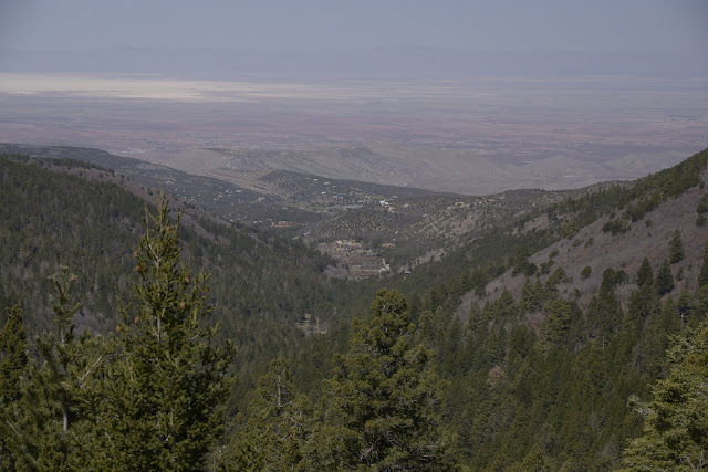
An unexpected treat was a scenic overlook (with nice parking) at the "Cloudcroft Tunnel" approximately half way up the climb to Croudcroft.  This allowed spectacular views back down Fresnal Canyon towards Alamogordo in the Tularosa Basin below.  Clearly visible are the brilliant white sands of White Sand National Monument in the distance.  That was in spite of the considerable amount of dust in the air in the basin due to strong winds.

View to the west from Cloudcroft Tunnel overlook
  
Mexican Canyon Trestle

Another unexpected treat was the view of the Mexican Canyon Trestle, just outside of Cloudcroft.  The trestle was originally built in 1899 as part of the Alamogordo and Sacramento Mountain Railway or "Cloud Climbing Railroad", but only recently restored in late 2011.  There is a very nice turnout with lots of parking and interpretative signs.


Mexican Canyon trestle from vista overlook on US 82

The railroad was built to haul lumber out of the Sacramento Mountains.  The railroad was built before roads existed and even before the area was mapped.  I found this description online: 
The Alamogordo and Sacramento Mountain Railway traveled between Alamogordo and Cloudcroft and was built 13 years before New Mexico became a state. Though primarily used for hauling lumber, passenger excursions could be purchased for $3 round-trip from El Paso and the money supplemented the income from hauling logs.
 Moving at a slow crawl for much of the trip, trains pulled passengers and cargo up steep 6 percent grades and through hairpin curves. The trains traveled 26 miles over 58 trestles and climbed to 8,600 feet, making the A&SM railway the highest standard gauge track of its time. Throughout the years, the introduction of internal combustion engine trains and a state highway led to the decline of the railroad and in 1947, the tracks were torn up and sold as scrap."
I did not find out until later, but much of the original rail bed has been converted into a system of hiking trails, the Cloud-Climbing Rail Trail, as part of the Rails to Trails program, including a short trail that goes from Cloudcroft to the backside of the Mexican Canyon Trestle

We did not spend a lot of time here, because it was actually rather cold due to the strong wind and high altitude.  Despite the cold, this was a very interesting stop. 

NM 6563 -- Sunspot Scenic Byway

Our next destination was the National Solar Observatory on Sacramento Peak in Sunspot, NM.  Access was via New Mexico route 6563, a 16 mile trip from Cloudcroft to Sunspot.  This, like so much of the day, turned out to be yet another unexpected pleasure.

NM 6563 is a beautiful scenic byway through the Lincoln National Forest, with several stunning scenic overlooks of the Tularosa Basin below.

An interesting feature of the Sunspot Scenic Byway was the Sunspot Solar System Model (scale 1:250 million).  We quickly figured out what was going on when we saw signs for the planets along the road as we approached Sunspot.  From the Sunspot Scenic Byway brochure:

"If you shrink the solar system so it just stretches from Sunspot to Cloudcroft, the Sun (at our Visitor's Center) would be 5.5m (18' 3") in diameter, and Earth the size of a 2" circle.  The inner planets would be on Solar Physics Drive at Sunspot, the gas giant long the Sunspot Highway, and Pluto in Cloudcroft."
The solar system model was well done and definitely a nice added touch.


Scenic overlook of Tularosa Basin above Alamogordo on Sunspot Scenic Byway (NM 6563).  White Sands is visible in the distance.

Geek Alert:  One more thing that was mentioned in the Solar Observatory pamphlet about the Sunspot Scenic Byway, "6563 is the wavelength in Angstroms of light produced by hydrogen gas at about 10,000 K.  Images in this deep red color -- H-alpha -- help find and track active areas on the Sun."  Other than roll my eyes, I don't know what to say about this.  Did they name the road or did they come up with this based on the existing number?


National Solar Observatory, Sunspot, NM

After the very pleasant trip through the Lincoln National Forest, we made it to the National Solar Observatory in Sunspot.  It is on Sacramento Peak and is at an elevation of 9200 feet.  As noted in their materials, the site was chosen in 1947 as an excellent location for observing the sun due to the dry air, isolation from any major source of air pollution, and plenty of sunshine.

The NSO is actually a small campus of multiple buildings (instruments) spread over multiple acres.  It was practically deserted when we were there, but we took the self-guided walking tour.

One of the most noteable sites is the Dunn Solar Telescope.  It is on a hill and rises 136 feet above the ground.  However, the building extends 228 feet below the ground.  The rotating part of the telescope is suspended or floats on 10 tons of mercury.

Dunn Solar Telescope

The sky was stunningly clear at this altitude.  There was also a scenic overlook with more views of the basin below.


At the NSO overlook with the Dunn Solar Telescope in the background


View from the overlook at the National Solar Observatory.  Note White Sands in the basin.  I am not sure it is the same canyon, but the rock face in the center is similar to what we saw at the Cloudcroft Tunnel.

After exploring the National Solar Observatory, we made it back to Cloudcroft for a late lunch.  We then headed east on US 82.  


Art in Artesia, NM

Approximately 90 miles east of Cloudcroft we finally made it to Artesia.  We were in need of a break and fortuitously pulled into a small park near the center of town with a spectacular bronze sculpture called "The Derrick Floor".  It is a model of a 1950's drilling rig.  For some reason we did not take any pictures, but I pulled the ones below from the website by the sculptor, Vic Payne.  He, by the way, has also done a number of the pieces in front of Cabela's around the country.

"The Derrick Floor" from http://www.vicpaynestudio.com/v2/Art_view.cfm?art_id=32


"The Derrick Floor"  from http://www.vicpaynestudio.com/v2/Art_view.cfm?art_id=32


Partners (Mack Chase and Johnny Gray)
"The Partners" located next to "The Derrick Floor".  From http://www.vicpaynestudio.com/v2/Art_view.cfm?art_id=93  We loved the fact that they were leaning on the front of their Ford pick-up.


We had no idea there was significant oil production in southeastern New Mexico, but it makes sense since it is not far from the oil fields of west Texas.  In addition to this impressive set of bronze sculptures, we noted several more bronze sculptures on the street corners of downtown.  Artesia appeared to be a very interesting and prosperous small community, no doubt aided by the large refinery we could see east of downtown.

Near the middle of town we turned south on US 285, heading towards our destination for the night, Carlsbad, NM.

Saturday, April 6, 2013

White Sands National Monument

Saturday, April 6 (Part III)


White Sands National Monument


We had started the day at Trinity Site near the north end of the White Sands Missile Range.  Our next stop was in the southern portion of White Sands Missile Range, White Sands National Monument.  It is the world's largest gypsum dune field, 275 square miles of white sand dunes, approximately 15 miles west of Alamogordo.  All of the dune field is within the southern portion of White Sands Missile Range, although not all of the dune field is part of the National Monument.

Gypsum

Not only is the size of the dune field impressive, but the makeup of the sand is also noteworthy.  Most sand is silica based.  However, the sand here is gypsum (calcium sulfate dihydrate, CaSO4·2H2O). Gypsum, the same material used in making drywall or "gyp board", is quite soft and soluble in water! The gypsum was originally deposited in the mountains above this area.  Snow and rainfall dissolved the gypsum and brought it into the valley, where it collected in Lake Lucerno.  There is no outlet from this valley and it is very dry, so when the water in the lake evaporated it left behind crystalline gypsum, known as selenite, in the dry lake bed.  The prevailing winds from the southwest broke up the crystals and blew them to the northeast, where they accumulated into the dunes.  Most of this happened in prehistoric times, but it continues even today. 


After a quick stop at the visitor center, we set off down the eight mile (16 mile round trip) dunes drive.  We did not know what to expect, but quickly found this to be a remarkable place. At the edge of the dune field are parabolic dunes.  Here plants anchor the constantly blowing (and hence constantly shifting) dunes such that the shape of the dunes become parabolic in shape. 

Beginning of Big Dune Nature Trail, at the dunefield edge with parabolic dunes

We found the landscape and the few plants that have adapted to this harsh environment to be quite beautiful.


Frog with camera on the main dune road

The drifting sand means that the road needs to be continually plowed like snow.  Even then, the sand was fairly deep in some places.  We saw a car hopelessly stranded in deep sand in the parking lot of the Interdune Boardwalk.


Because of the moving dunes, all buildings within the dune field (e.g. restrooms and picnic shelters) are built on pallets so that they can be moved relatively easily, as needed.  We never did find the Nature Center denoted on the map, but were told later it had been removed due to shifting dunes.  In fact, the road is not paved beyond the Interdune Boardwalk because its location must be changed over time as the dunes shift.


 Further into the dune field, the landscape changes as there is more sand and fewer plants.


That did not mean there were no people. The large dunes made for some interesting sledding.


We went on the "Sunset Stroll" with the ranger and found out much more about this interesting place.  For example, there is water at rather shallow depths below the sand (at least between the dunes).  One strategy adapted by the plants is to develop long stems that stick up through the dunes.  These are then seen in their collapsed form after the dune moves forward as shown below.  The sand is almost soft to the touch but, at least on the flat areas, was much firmer than expected.  That is apparently due to the gypsum hardening when it becomes wet.


Although there was a pretty good crowd in the park on Saturday evening, we had the place nearly to ourselves when we returned the following morning.  That gave us the opportunity to take some additional pictures.


Turkey on the road across from the Interdune Boardwalk early on Sunday morning


Blowup of the sand behind the Turkey showing the many tracks left by creatures from the night before

This was a remarkable place.  Hopefully we can return some day and do some hiking on some of the trails or take the ranger led trek to Lake Lucero.

Petroglyphs and Pistachios

Saturday, April 6 (continued)

Three Rivers Petroglyph Site

Next stop for the day was the Three Rivers Petroglyph Site.  This interesting location of over 21,400 petroglyphs is managed by the Bureau of Land ManagementI am not sure the difference between all of the different types of ancient drawings, but here a petroglyph is a drawing created by scratching off the dark patina on the rocks such that the lighter colored main portion of the rock shows through.  We ate our lunch (hotdogs from the Trinity Site) at the very nice picnic tables in the parking lot, then headed up the trail. 


Map of Three Rivers Petroglyph Site


It was an easy to follow but steep trail, made more challenging by the gusty winds that were especially strong on top of the ridge.


Once we made it to the top of the hill, there were petroglyphs literally everywhere. 


Eagle head in the center


The bighorn sheep (upper left) is #4 on the self-guided tour.  The broken rock to the right of the sheep shows the dark oxidation layer or patina on the outside and the lighter interior rock.


Close-up of another rock showing the outer, dark colored patina


The four-legged creature in the background is #11 on the self-guided tour. 

Not all petroglyphs were animals or people.  Some were elaborate designs.


The circle and dot motif was very common.  According to the trail guide, it accounts for more than 10% of the 21,400 petroglyphs at this site, although it is not common at other rock art sites.  Researchers think the circle and dots may represent corn or population count. Well...maybe.

I am glad we were not here in the middle of the summer.  The heat would have been brutal with no shade.  Even with the lower temperatures of spring, I was very thirsty from the altitude and the wind, so I gave out at the rest area marked on the map.  We did not see all 21,400 petroglyphs, but I am very glad we stopped.  It was a very interesting place to visit.

World's Largest Pistachio Nut

We were quickly back on US 54 heading south towards Alamogordo.  Near Tularosa, New Mexico, we saw numerous tree farms with lots of trees in neat rows which we assumed were pecans.  Indeed, the region is known for their pecan trees.  However, it soon became clear that pecans were not the only nuts grown here.  On the west side of the road (just south of Dingo Road), is McGinn's Pistachio Tree Ranch.  We might have missed the sign, but there was no missing the 30 foot tall pistachio in the parking lot, the world's largest pistachio nut.  We did not stop to take a picture, (I know, what were we thinking!?) but here is a pic I stole from the web.


World's largest pistachio, McGinn's Pistachio Tree Ranch
According to this YouTube video showing the mechanized harvesting and processing of the nuts, McGinn's has over 12,000 pistachio trees. New Mexico is in the midst of a record drought.  I hope they will have enough water to keep the trees alive.

We continued southward to Alamogordo and eventually to the next major stop of the day, White Sands National Monument.  That is the subject of the next post.