Monday, December 30, 2013

Flurry of Activity

It is always so much fun to hang out with Paul and Gwen.  There is such a flurry of activity.  They are currently deeply involved in the Society for Creative Anachronism.  Although I had always associated that with battlefield reenactments (and Paul, with his sword and shield, is involved with that), it is so much more.  Gwen has created stunning costumes for both of them.  I still don't know why I did not take pictures, but here is one I stole from Gwen's facebook page.


Photo
Gwen at Fall Coronation, as stolen from Facebook
She showed us some of the intricacies of the various costumes, including how the hoop on her hoop skirt had to be modified so she could go through a standard size door.  She also explained how she designed and fitted Paul's garments he wears into battle.

Here is Paul outfitted for battle in a photo I stole from Facebook.  He did show us some of his sword (is it called a sword?) moves in the backyard.  I was impressed with the many planned moves.  It was not random slashing.

Paul (on right) preparing for battle...stolen from Facebook


Among the other activities related to SCA, Paul is also a bard (meaning lots of poetry) and a herald.  Gwen is heavily into various period crafts, including various types of weaving.  Some of the needlework is stunning.

They are also both into wine, mead, and beer making. These beverage preparations were the focus of much of the activity while we were there.  Unfortunately, I have only spotty photographic coverage of the whole process and I don't remember what was happening in each of the pictures. However, this gives a sense of the process.

Washing (sanitizing) a bottle that will serve as a fermentation vessel

Here is the premeasured grain (barley, malt, and oats) purchased online for "stubby oatmeal stout" homebrewed beer, the beer du jour.

Premeasured grain purchased online

And this is how it is done, although they removed the grain from the sock rather than merely dipping it into the water.

page 1 of instructions


10:09 am


11:44 am -- Cooling the wort


12:08 pm


Although I do not have pictures (what was I thinking?!), the beer went into a fermenter with a bubbler on top and was placed in the shower to allow the yeasts to do their thing.  That process is described in the instructions below.

page 2 of instructions

Beer making was not the only activity.  This was one of Gwen's creations (cranberry mead, I think) that had been fermenting for some time and was now ready to be transferred into bottles.

Siphoning from the fermenter into bottles


I am afraid we may have been a distraction, especially with all of our questions, but it was lots of fun seeing all of this in person.  Of course, all of this activity was in addition to the wonderful gourmet meals we had throughout our stay.

Friday, December 27, 2013

Westwad Ho

This was such a super trip.  It was so wonderful getting to visit our kids whom we rarely get to see.  I have been procrastinating about posting about it (it is now 2-12-14) because anything I can post about it now does not do it justice and tends to make me homesick to see them again.  However, I need to get this done soon or it will not happen, so here goes the first of several posts to cover this great trip. 

We celebrated Christmas among the three of us.  Here is Alex with his Christmas present, a "Drinkwell Zen Fountain" watering bowl.  He has always preferred drinking from the faucets in the bathroom, so we hoped this filtered, flowing water would be cat approved.

Alex drinking from his Zen Fountain.  The water is filtered through a charcoal filter and flows onto the metal ledge rather than dripping, the latter to cut down on noise.  We thought the low noise feature was just marketing hype, but it is actually quiet once the water flow is adjusted correctly.

We got everything packed, left plenty of dry food and water (both in the new fountain and otherwise) for Alex, then headed west about 7 am on December 26.  The plan was to get to at least El Paso and take 2.5 days to get to Santa Barbara.  With very favorable weather and the addition of an hour due to the time zone change, we made it all the way to Deming, NM.  This is about halfway and has been a common place for us to stay, whether in a car or in Silver, on numerous trips back and forth across the Southwest.  We ate dinner at the Rancher's Grill steak restaurant.  The food was just ok, but we had fun looking at the many cattle brands on the wall in the lobby. 

We headed out early the following day with continued great weather, although cold...in the 20's.  The trip was uneventful, but it is always interesting to see the saguaro cacti along I-8 south of Phoenix in the Sonoran Desert National Monument.  


http://upload.wikimedia.org/wikipedia/commons/0/0c/Son_des_49790.jpg
Picture is from this site:  http://en.wikipedia.org/wiki/Sonoran_Desert_National_Monument

Another highlight is the "valley of the wind turbines" in California, the San Gorgonio Pass Wind Farm, near Palm Springs.  We had passed multiple wind turbines the day before in west Texas, including many near Sweetwater, TX and Big Springs, TX.   In fact, Sweetwater makes claim through its large welcome signs along the interstate to being the Wind Energy Capital of North America.  I guess that is better than only being known for the world's largest rattlesnake roundup each March.

Once we turn west and start driving across the 210 west of San Bernardino, it feels like we are getting close.  We know it is not really true, but it always feels that way.  At that point, through the miracle of cell phones, we checked in several times with Gwen to let her know we were on our way.  Despite heavier traffic in areas north and northwest of LA, we made it to Santa Barbara in time for dinner.

Monday, November 4, 2013

Talimena Scenic Drive

We had long wanted to see some of the fall colors in Oklahoma.  A prime location for such viewing is supposed to be the Talimena National Scenic Byway. This road is a combination of Oklahoma 1 and Arkansas 88 between Talhina, OK, and Mena, AR (see map below).  The name of the drive comes from combining the names of the towns at the two ends.

Map of Talimena National Scenic Byway

The 54 mile, two lane road is completely within the Ouachita National Forest, the oldest national forest in the southern U.S., and travels along the ridge line of the Winding Stair Mountains, part of the Ouachita Mountain chain.  Although the winding road mostly follows the narrow ridge line, it does have 13% grades in some locations. The road originally opened in 1969, but was not designated a National Scenic Byway until 2005.

We left about 9 am Friday morning, heading towards Oklahoma via Texas Highway 121. After multiple stops for lunch, gas, and a map at the visitor center at the west end, we headed up the drive starting a little before 2 pm.

With 22 scenic pull outs, there were many easy places to stop and take pictures.

Frog taking pictures at Deadman Vista

 The sky was mostly overcast, so the tree colors were somewhat subdued.  However, it was still beautiful.
  
Looking east near Kerr Botanical Center

 Interestingly, these mountains are among the few in the U.S. that run east and west, leading to dramatically different climate and hence different vegetation on the northern and southern slopes.

Signage describing the different trees on the north and south slopes

  Most noteably, the deciduous trees (and hence the fall colors) are almost exclusively on the northern slopes.


North facing slope

But even the southern facing slopes, with mostly evergreens, looked nice.

A few hardwoods among the pine trees

We had not made motel reservations for the night, so were worried about finding a place to stay.  Everything turned out ok.  The motels in Mena were not upscale, but we did find a room.  Most interesting was the two story log cabin restaurant, The Chopping Block, where we had dinner.  Not only was the food good, but the photographs on the walls were particularly nice.  It turns out the owner is also a local photographer.

We headed out early the following morning for the return trip westward along the Talimena Drive.  It was cold (low 40's) and very windy.  We were early enough to miss most of the heavy Saturday traffic along the road and at the turnouts, but we still saw many motorcycles and multiple special cars, including many Corvettes, by the time we exited.

We made a brief stop at Queen Wilhelmena State Park, which is right along the Talimena Byway.  Unfortunately the lodge and restaurant were closed due to a multi-year renovation.  We did explore the railroad engine at the entrance.  It was so cold and windy on top of the ridge, we did not linger long.

In the engine at Queen Wilhelmena State Park


Kerr Botanical Garden
On the way home about 19 miles south of Talhina, we made a slight (1 mile) detour off highway 271 to visit the Choctaw Nation Museum at the Capitol of the Choctaw Nation.  The museum was closed, but we did see some of the outdoor displays. 

Choctaw Nation Museum
Overall, the trip was great and well worth the drive.  We are especially glad we went when we did.  The foliage was already past its prime on the Arkansas end of the byway.  With the wind and predicted rain, most of the leaves will probably be gone soon.

Saturday, June 8, 2013

Wandering Through Waco

After spending the morning at Mother Neff SP, we decided to check out some things in Waco that we had never taken the time to see.

Baylor University Bear Habitat

First on the list was a stop at the bear habitat for Joy and Lady, the real life mascots on the Baylor University campus.  The habitat was beautiful, with grass, waterfall, wading pool, and several enclosures/caves.  It was less than ten years old and looked very well maintained.  However, the way the bears paced and walked in circles, I think they were at best very bored.  Apparently they get to go on walks across campus...I'd love to see that!

One of the bears doing laps


View of the bear habitat through the glass


Testing the water


Suspension Bridge

Next stop was the nearby Waco Suspension Bridge over the Brazos River.  Completed in 1870, it was built by local businessmen to provide a river crossing on the Chisholm Trail for cattle, pedestrians, and wagons and hence bring economic development to the city.

At the time, it was apparently the longest single-span suspension bridge (main span of 475 feet) in the world. 


The entire bridge and especially the twin double towers, made of more than 3 million locally made bricks, were considered engineering marvels of their time.  It was reportedly a model for the Brooklyn Bridge, which was built by the same company a decade later.
 

Looking towards the north (east) side of the river from the middle of the bridge


Pigeons enjoying the view from the bridge

Looking to the south (west) side of the river

The completion of the bridge was even more miraculous given the lack of transportation and construction infrastructure at that time:

Due to lack of machine shops in the Waco area, getting the materials to the building site was a journey in itself. The nearest railroad was 100 miles (160 km) away, and the closest town with artisans with the skills needed was Galveston, over 212 miles (341 km) from the build site. Supplies were loaded onto a steamer in Galveston, and ferried to Bryan. From there, they were loaded onto wagons pulled by oxen. The pothole-filled dirt road from Bryan to Waco was bad, even by 19th century Texas standards.

The bridge underwent significant modification, including replacement of the cables and steel reinforcement for the deck, in 1914.  It remained open to vehicle traffic until 1971, when it became pedestrian only.  It is still an impressive structure and interesting to walk across given that the decking is wood.


'Branding the Brazos' Cattle Drive Sculpture

Commemorating the cattle drives that crossed the river here is an impressive set of bronze sculptures at the west (south) entrance to the bridge.  The sculptures have already been over a decade in the making and thus far include a cowboy on horseback and multiple cattle.  It will eventually include three cowboys on horseback and a herd of 25 longhorn steers.  According to an article in the Waco Tribune earlier this year, the entire project may be finished by late 2013.  The work is being done by artist Robert Summers, who did the sculptures at Dallas Pioneer Park as well as some of the work we saw earlier this year on our travels through New Mexico.  It will definitely be worth a trip back to Waco to see it when it is completed.  I am also wondering if the foundry in Bastrop that is making these, Deep in the Heart Art Foundry, offers tours.  Based on their info on the web (e.g. here, here, or here), that would really be something to see!

These guys are big!


The first of three cowboys to be included in the completed set of sculptures


Three of the cattle near the entrance to the bridge.  Notice the City of Waco brand on their sides


The Frog in a steer traffic jam

 
Waco Mammoth Site

Last but certainly not least was the Waco Mammoth Site, on the northwest side of Waco.  A large animal bone was discovered by hikers exploring this area in 1978.  It was subsequently identified as being from a Columbian mammoth, an extinct species that dates back to the Pleistocene Era (2.5 million to 10,000 years ago).  Excavation resulted in the discovery of a complete skeleton and a whole lot more.  To date, 24 Columbian mammoths and at least one camel have been found at this site.  Research suggests that 19 of the mammoths were trapped by a flood event and perished approximately 68,000 years ago.  Bones from at least two later events are also present.  One event, which was 15,000 years after the first flood, involved a male (bull) mammoth, a female and a juvenile.


What is there to see at the site?   There is a climate controlled dig shelter and suspended walkway over several of the mammoth fossils and the camel fossil, all still in place.

Inside the entrance to the dig shelter.  The dig site is below and to the right.


Life size depiction of a bull Columbian mammoth.  The bones are in the pit in the foreground.

 
Map of the bones in the pit as seen from in front of the mammoth shown in the previous picture


Tusks of the bull mammoth (Mammoth Q)


Life size male Columbian mammoth, in this case 13.5 feet to the shoulder--2 to 4 feet taller than wooly mammoths which were not in Texas.  They stayed in colder climates further north.

This site is the only known discovery of a nursery herd (female mammoths and offspring) in North America and the largest known collection of Columbian mammoths to have died in a single event.  There is strong evidence that there are more bones to be found in the area. There have been several attempts to make the site a National Monument under the direction of the National Park Service, but each time that has become hung up in Congress.

The site is very interesting, but the tour was fantastic due to our particular tour guide.  Among the new factoids we discovered:  The climate during the Pleistocene Era was only about 5 degrees cooler than present day temperatures.  Most animals currently living in Texas also existed during the Pleistocene Era.  Among the extinct species was an armadillo the size of a VW bug.  Columbian mammoths, growing to more than 14 feet in height and weighing up to 10 tons, were one of the largest mammals to live during the Pleistocene Era and were considerably larger than their distant relatives the wooly mammoths.  Their teeth (the size of a shoebox) were continually being regenerated because they were worn down by the constant grazing.  The bones being excavated are very fragile because they have not become mineralized.  It is not yet understood why many large mammals became extinct at the end of the Pleistocene Era.

Needless to say, we really enjoyed our visit here. 

Mother Neff State Park

State Park Caching Quest

The weather forecast is for at least one more day of below normal temperatures before the heat arrives with a vengeance next week.  We thought we should take advantage of the projected beautiful weather for an outside day and in particular our current geocaching quest.  Our current goal is to find a geocache in every Texas state park. We would have probably chosen to do that on our own, but it is also an 'official' geocaching challenge, GC2YEMM.   It is made even more interesting and more doable by the caches added by the state parks themselves as part of the Texas State Park Geocache Challenge.  

By our count, there are currently 76 Texas state parks, although that number keeps changing.  Thus far we have found 154 geocaches in 51 different state parks.  However, Texas is a BIG state. Most of the parks not yet crossed off our list are at least a three hour drive one way, with many much further.  What to do for only one day?  The one exception to the above was Mother Neff State Park, southwest of Waco, which is about a 2.5 hour drive.  Mother Neff SP it is!  

Trip down I-35

We loaded GeoJeep and were on the road by 7:30.  One of the amazing sights along I-35 was fields of sunflowers.  The fields were huge and the yellow was extraordinarily intense.   I don't know when they harvest sunflowers, but the flowers were certainly a beautiful sight.  Although all of the blooms within a field seemed to be pointed in one direction, subsequent googling indicated they do not track the sun.

Mother Neff SP -- the first Texas State Park

We pulled into the park a little before 10, got registered, then were off to the trail head.  This was an interesting park and much different than what we had expected.  There was an area at the entrance that was open and flat, which periodically undergoes lots of flooding when the adjacent river overflows its banks.  Much of the remainder of the park is a cedar forest with lots of up and down through limestone formations.  

Not only is the terrain interesting, but the park has an interesting historyMother Neff SP is the first Texas state park.  It is on land donated by the mother of the then governor of the state.  There were multiple historical features dating back to the time of the native Americans and multiple CCC structures.  

Sign at the cave


Frog atop the 11,000 gallon CCC water tower.  Not sure of the height, but it is 20 steps to the top.


There were also some interesting blue flowers in bloom throughout the park.  Blue is an unusual color and really stood out along the trail. 

Checking out the blue flowers


Research after we returned home revealed that these blue flowers are called "dayflowers" because they only exist for one day.  There are two large petals, with a smaller white petal somewhat hidden below the others.


Texas Dayflowers

We checked out the various features in the park and found three of the five geocaches.  Now we have 157 geocaches in 52 different state parks (plus an additional nine state historical sites or other state locations).  Only 24 more parks to go!!

Wednesday, May 15, 2013

Big Thicket


Our last major destination for this trip was the Big Thicket.  We had certainly heard of it many times, but we did not have a clear understanding of exactly what it was.  That is probably because the term refers to both a general definition of the region and also refers to the federal lands set aside as the Big Thicket National Preserve.  Even with that, we did not know what to expect.  Here is what we have subsequently found out:

Big Thicket Region

The Big Thicket is a heavily forested region of southeast Texas that occupies much of at least five counties.  Prior to the Texas Revolution the region extended between the Old San Antonio Road (or Camino Real) and the Atascosito Road to the south and between the Brazos River to the west and the Sabine River to the East. However, older families in the region tend to define a much smaller region (40 miles long and 20 miles wide in Polk and Tyler Counties), now sometimes referred to as the "bear hunters' thicket".  All of these boundaries are somewhat difficult to define today because of the heavy lumbering and oil activities in the region in modern times.


Historical range of the Big Thicket (downloaded from http://en.wikipedia.org/wiki/File:Old_Big_Thicket.png)


Big Thicket National Preserve

The Big Thicket has a very interesting history, but it is most noteworthy for its biological diversity.

The Big Thicket is possibly the most biologically diverse area in the world. Cactus and ferns, beech trees and orchids, camellias and azaleas and four carnivorous plants all occupy what is called the thicket, along with the pines, oaks, and gums common to the rest of East Texas. The thicket also supports a wide variety of animal life and is especially noted for the many species of birds, around 350, that either live in the area or visit annually. 

To preserve this unique area, a portion of the historical region was designated in 1974 as the Big Thicket National Preserve, the first national preserve in the National Park System.  Creek corridors and additional land were added in 1993.  The current federal lands that make up the Big Thicket National Preserve (approximately 106,000 acres) are only a small part of the original Big Thicket region and are in 15 different non-contiguous units, nine land units and six water units.

Fortunately, we started our visit at the new Visitor's Center (corner of FM 420 and US 69, not the info station shown on the map below), which helped put all of this in perspective.  I was particularly interested in seeing some of the carnivorous plants known to grow in the preserve.  The ranger supplied us with a detailed map and helped us identify three trails to explore for our introduction to the Big Thicket: the Kirby Nature Trail at the southern end of the Turkey Creek Unit, the Sundew Trail in the Hickory Creek Savannah Unit, and the Pitcher Plant Trail at the northern end of the Turkey Creek Unit.

Some of the units in the Big Thicket National Preserve (downloaded from http://www.canoetexas.com/btmap.html)


Kirby Nature Trail

The Kirby Nature Trail, at least as we took it, was a well maintained 1.8 mile trail through a heavily forested area of various hardwoods and pine approximately 2.5 miles east of the Visitor's Center.

Kirby Trail


It also included a cypress slough and boardwalks over wet areas.  Although I think it would have been tough, it is listed as wheelchair accessible.

Cypress Slough on the Kirby Trail

There were many different micro-environments and many different types of plants.  Fortunately we bought the guide (only $1) at the visitors center.  Although it meant we took a very long time to make the loop, it provided us with a huge amount of information.


Sundew Trail

After a trip back to Kountze for lunch, we headed north on US 69 to the Hickory Creek Savannah Unit and the Sundew Trail.  This area was a bit more open and was actually quite dry, although it must at times have a considerable amount of water in some areas.

Frog taking pictures on the Sundew Trail in the Big Thicket National Preserve


One of many lizards we saw on this trip.


We had come here to see the sundew plants, a carnivorous plant that traps its prey with a sticky substance on the exterior of the plant.  We stumbled upon a few trumpet plants, but we originally did not see the sundew plants because we did not realize how very small they were.  The pictures that we had seen in the visitor's center were closeups that made them seem much larger.  The small round red clusters were hidden among the grass on the ground.   Each cluster consisted of multiple paddle-shaped leaves coming from a common center.  Each leaf terminated in a round globe covered with sticky hairs.  The sticky hairs were not really visible since they were so small.  An entire cluster with six to eight offshoots was no larger than a dime.


Sundew plants (the little red things) hidden among the grass next to the boardwalk


Pitcher Plant Trail

We were very much enjoying our visit to Big Thicket.  However, nothing had prepared us for what we saw at our next stop, the Pitcher Plant Trail at the north end of the Turkey Creek Unit.  It is a bit out of the way and the unpaved road is reportedly very bad when wet, but it is well worth the effort to find this place.

We started down the trail after looking briefly at the map at the trail head.  After having had so much trouble finding the sundew plants at the last stop, we were concerned we would not find the pitcher plants, another type of carnivorous plant.  We did not need to be concerned.  Once we came to the location with the pitcher plants, they were literally everywhere.


Pitcher plants along the boardwalk on the Pitcher Plant Trail

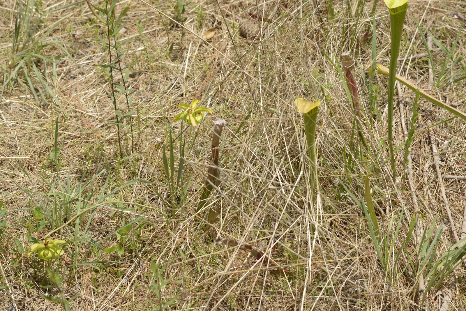
From a distance the pitchers almost looked like yellow flowers.


Pitcher plants
We did not know until after we got home, but the pitcher plants we saw are actually the leaves of the plant that have formed a tube at the top.  The insects are attracted to the inside of the plant, but cannot crawl out due to hairs pointing downwards. 

Trying to keep one of the pitchers from swaying in the strong wind so the Frog could get a closeup. 

The flower is separate and has five petals on a leafless stem.  We did not see any of the flowers on the Pitcher Plant Trail, but had seen a couple with the few isolated pitcher plants that we saw on the Sundew Trail.

The "pitcher" (on the right) is a large leaf that forms a tube at the top.  The pitcher plant flower (on the left) has five petals and points downwards.  These were actually along the Sundew Trail. 

Most amazing of all...we even saw an orchid among some of the pitcher plants!  We had no idea they grew wild in Texas. 

A wild orchid among the pitcher plants on the Pitcher Plant Trail


We continued around the entire loop, including a significant area that had recently been burned.  However, the main attraction on this trail was clearly the one localized area that contained the pitcher plants.