Glacier Bay National Park. August 1 was the day we were scheduled to enter Glacier Bay National Park. The national park is about 3.3 million acres or 5100 square miles, which is larger than the state of Connecticut. The central portion of the park is the waterway Glacier Bay, which extends through the center of the park more than 65 miles northward from its mouth on Icy Strait. Below is the gps track of our trip through the park.
 |
| Glacier Bay NP is shown in green on this map. The blue line is our gps track. |
Access is only via boat or plane. Almost all visitors enter by cruise ship, with the vast majority (>90%) never leaving their ship. Not us! We would be off the ship twice today. That does not count tomorrow's adventures.
Despite its enormous size, most of the park is wilderness. There are only about 22 miles of trails, all located near the Visitor Center in the far southeastern corner of the park. Over a quarter of the park's area (more than 1375 square miles) is covered by its more than 1,000 glaciers
Changing Ice. Despite the large amount of ice it is a small fraction of the coverage just a few hundred years ago and has been changing rapidly. Glacier Bay is actually a giant fjord carved out by glaciers. In 1680 Tlingit native peoples lived on a broad valley where the lower Glacier Bay currently exists. By 1750, the Little Ice Age had come. The glacier extended well out into Icy Strait and had totally covered the Tlingit's native lands. When George Vancouver's expedition sailed past in Icy Strait in 1794 the glacier had already begun to recede. It had backed five miles into the bay but was still enormous. They described the giant glacier as miles wide and over 3,900 feet thick. By the time John Muir first arrived in 1879 the glacier had receded more than 40 miles and had left behind all of lower Glacier Bay.
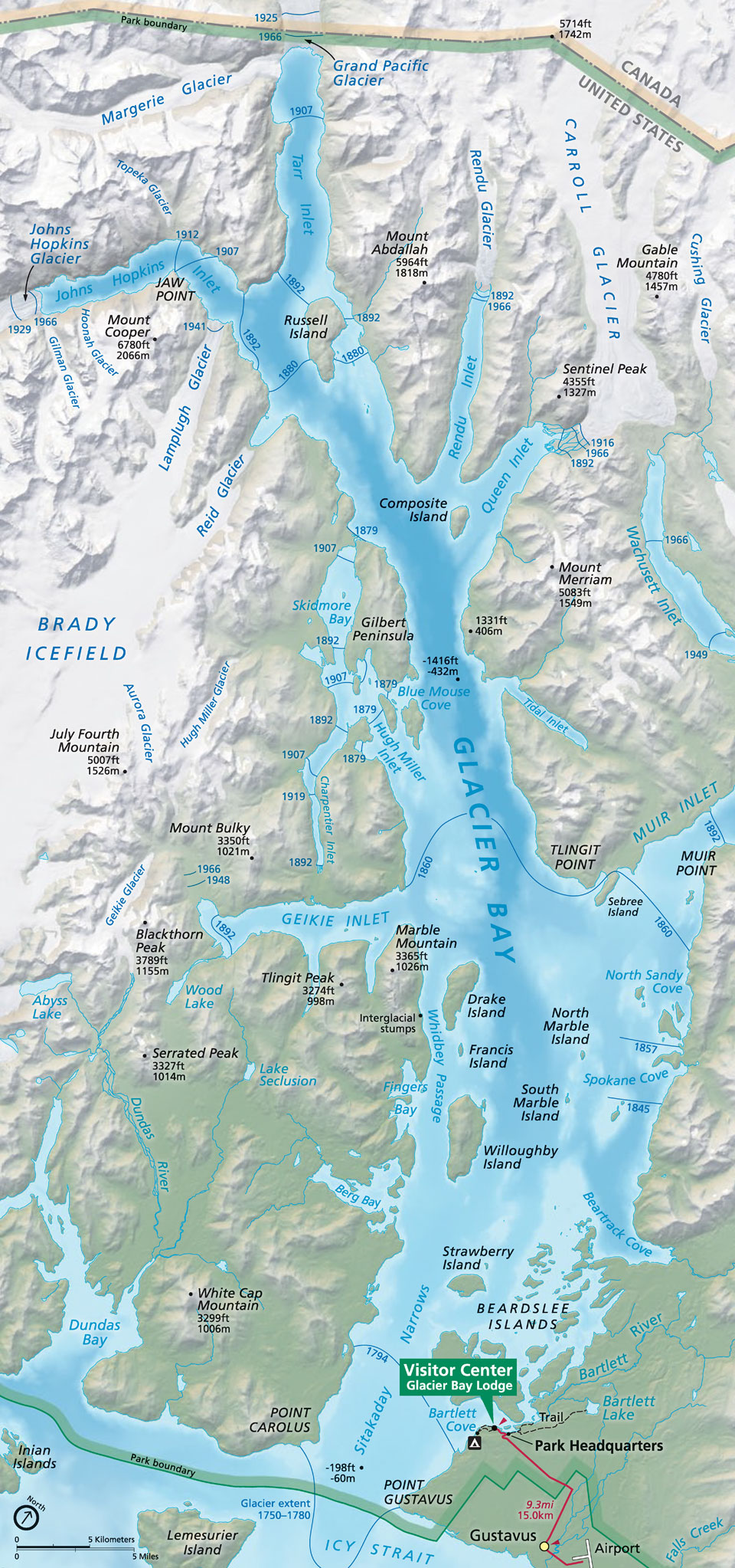
I discovered this map of Glacier Bay after we got home. It is supposedly supplied to all cruise ship visitors to the park, but we did not count as a cruise ship so we did not get one. It is the best map I have found so far to identify the glaciers along the bay. I was particularly intrigued with it since it shows the extent of the various glaciers as a function of time It does not lend itself well to insertion into the blog, but here is a portion of upper Glacier Bay. Go to this link for the full map. (Here are more maps available from the park service.)
 |
| NPS map of upper Glacier Bay. Extent of the various glaciers as a function of year is marked. Note that the map has been rotated clockwise. North is 30 degrees or so to the right. |
Rules aplenty. There are many many rules governing admission to and activities in Glacier Bay. Vessels must have a permit and most permits must be granted well in advance. The number of vessels that can operate in a day is limited to 2 cruise ships, 3 tour boats, 6 charter vessels, and 25 private vessels.
Vessels can only be in the park on the day of their permit, i.e. midnight to midnight. I am not sure which of the categories of ships the Safari Endeavor falls under, but it is not cruise ship. Although we only saw one cruise ship while we were there, I have often seen two large cruise ships in the park in addition to the Endeavor and/or other smaller ships when checking her location on Cruise Mapper.
Psyched for today's events. I was so excited that I woke up some time in the night to see if we had entered the park. I don't know what time it was, but it had to be early since it was still dark. The gps on the stand next to the bed indicated that we were already well on our way into Glacier Bay. I don't think I ever completely went back to sleep as I kept peeking behind the curtains to see if there was anything to see.
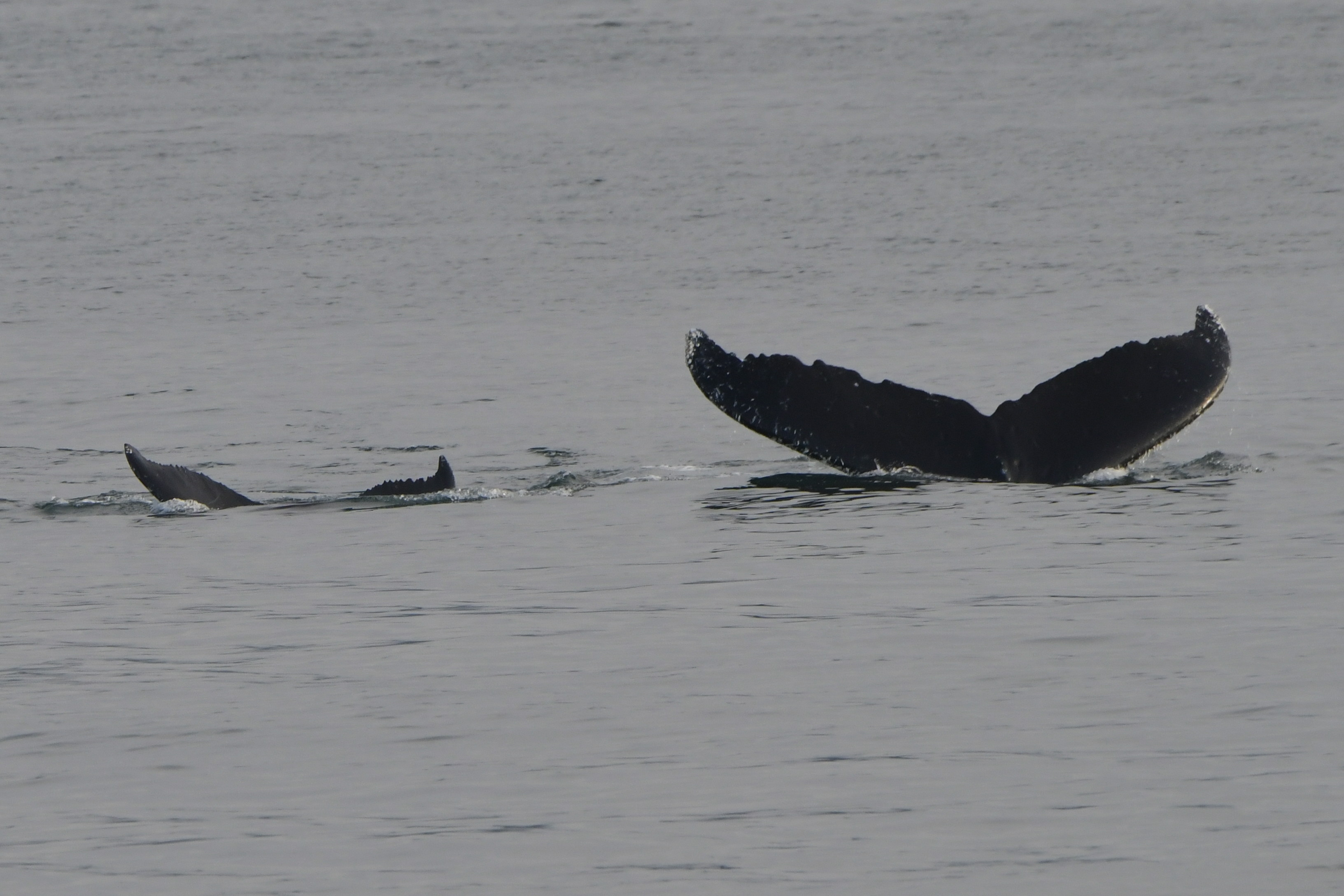
In retrospect I should have realized that we would enter the park as soon after midnight as possible so we would be close to the glaciers in the north end of the park by the time we were ready for the morning activities. Sixty five miles doesn't sound very far until you realize the ship can only go 13 mph and often may be restricted to lower speeds due to areas protecting animals such as humpback whales.
Sunrise over upper Glacier Bay. As the sun began to rise I got dressed and headed out to see what I could see. It was indescribably beautiful.
 |
| Sunrise on the Fairweather Mountains from upper Glacier Bay at 5:22 am. Glacier at the center on the right is Topeka Glacier. The shoreline in front of the glacier is about 14.5 miles away. The glacier to the left is Toyatte Glacier. The picture was taken roughly from the green marker on the gps track below |
The water was perfectly still and we were slowly cruising along at about 6 mph.
The first pictures were of the Fairweather Mountains straight ahead at just before 5:30 am. The pictures were taken roughly at the green marker on the gps
track below. Although I did not know it at the time, the glacier in the center on the right is Topeka Glacier. The glacier to the left is Toyatte
Glacier. The shoreline in front of them is nearly 15 miles away.
 |
| GPS track for the morning of 8-1-22. The green marker on the right is the location of the early morning sunrise pics. The yellow anchor is the Safari Endeavor anchorage while we were on the moraine walk, which is the red marker.. |
We were not the only people up, but we did not have to fight for a position to take pictures.
 |
| The Frog taking pictures from the bow of the ship (5:38 am) |
I kept thinking at the time that the pictures did not nearly do the experience justice, but I am certainly glad to have them now.
 |
| 5:58 am -- Getting closer and the sky is clearing |
By 6:00 am we were in front of Reid Glacier. It used to be a tidewater glacier, but has retreated well back into Reid Inlet and is now grounded. However it was my first geocache of the day
 | |
| Reid Glacier, 6:01 am. Note the ice floating in the foreground. |
We did not always know what we were looking at, but fortunately the Frog got one picture looking up Tarr Inlet towards Grand Pacific Glacier, the glacier that created all of Glacier Bay.
 |
| 6:13 am looking up Tarr Inlet off the starboard side of the ship. Grand Pacific Glacier is just visible on the left behind the point that sticks out in the foreground. The glacier is winding around the the left side of the knobby mountain in the center which is covered in fog. In pictures such as here Grand Pacific Glacier looks like a river of mud, since it is covered in debris from landslides. Margerie Glacier is not visible, but would be just around the point and to the left. Note the ice in the foreground, some of which looks very dark and muddy. |
 |
| Lamplugh Glacier, 6:44 am. Even from a distance it is obvious glaciers are not smooth on top. |
By 6:45 am we had reached Lamplugh Glacier, which we would be visiting on foot later in the morning. One of the glacier's notable features is its striations of dark debris, presumably due to landslides depositing layers of rock on its surface during its lifetime. Interestingly, there was a huge landslide of 132 million tons of rock that spread debris across six miles of the upper glacier in June, 2016. It was so large that it caused tremors of magnitude 5.5 on the Richter scale. All of that debris is moving with the glacier and should reach the terminus about 2030.
 |
| 6:45 am Lamplugh Glacier on the left and Mount Cooper on the right |
Like everything in Alaska, it is so hard to judge scale since everything is so big. Lamplugh Glacier is about 0.75 miles wide at its terminus and is 150-160 feet high. Mount Cooper, which is also in the picture above, seemed small and inconsequential compared to other mountains in the vicinity, but it is 6780 feet tall.
The ship anchored near land, but immediately adjacent was only vertical stone. Surprisingly there were lots of birds, including Pigeon Guillemots with their red feet, something totally new to us.
 |
| Lots of Pigeon Guillemots around the ship. Looks like barnacles on the rocks. Note the milky color of the water due to silt from the glaciers. |
We also saw gulls and cormorants. The presence of birds means plentiful fish in the water. The fish are plentiful due to the nutrients being pushed into the water by the glaciers.
 |
| Pigeon Guillemot with a fish in his mouth. I was intrigued by his red feet and legs. |
Moraine Walk. Next up were the morning off-ship adventures. We could have chosen kayaking, a skiff ride, a climb up the hill next to the glacier, or a walk on the moraine (area created by debris pushed in front of the glacier). The hike up the hill was billed as what would be the most challenging activity of the week, so we ruled that out. They warned us about all of the rocks we would have to maneuver over and around on the moraine, but we decided to give that a try.
 |
| The ship at anchor. We are on the open area on the third deck getting our life jackets on in preparation for the skiff ride to the moraine. |
 |
| Yes, really--I had to crop the previous picture like mad, but there we are on the third deck getting ready. |
We got our life jackets on, then boarded the skiff for the ride over to the moraine in front of the glacier. I could not tell at the time, but the gps track suggests it was a little over a mile from the ship to the drop off point.
This location lends itself to such off ship adventures near the glacier for several reasons.
- There is apparently a shallow spot in the bay with appropriate material on the bottom which makes for a good anchoring spot for the ship. Gwen explained this to me after they anchored here on their trip several years ago. At that time I noticed there had been a ship anchored in the same spot as their ship (and now our ship) in the picture on Google Earth. (Actually, I don't know how shallow it needs to be. I asked one of the crew how long the anchor chain was. She said 540 feet.)
- There is more than a 0.25 mile between the front of the glacier and the moraine. Hikers are protected from any ice breaking off of the front of the glacier and falling on them. Kayakers are protected from any wave that would form from calving ice.
- There is a good enough beach such that the skiff can come into shallow water to let us off and pick us up. It was a wet landing, hence the need for our calf-high boots (known as "Alaska sneakers"), but it was less than a foot deep.
 |
| Here we are starting out on the moraine after disembarking from the skiff. Note the stream coming from the glacier to the right. |
 |
| Looking back towards the Endeavor on the left. The skiff with the skiff ride people are in the bay on the right. The glacier stream is in the foreground. |
 |
| Exploring the moraine. Lots of rock was drug down the mountain and deposited here. |
 |
| This is one of the pictures used by UnCruise in their slide show the final night to introduce Glacier Bay NP, hence the black lettering. I added the red lettering to point out the people standing in front of the grounded icebergs. |
-zoomed.jpg) |
| This is one of the pictures taken by the folks climbing the hill. I cropped it so the people (the tiny black sticks in the lower right hand corner just this side of the icebergs) are visible. I am not sure if it was us or the group before us, but those are the icebergs we were exploring. |
 |
| The Turkey and the Frog in front of one of the icebergs. |
.jpg) |
| From the top of the hill. The glacier is on the left. The area it had carved out before receding is visible below in the foreground with the "tiny" icebergs along the edge. The under glacier stream beyond the pool in front of the glacier is not real clear, but you can see all of the gray silt from the stream as it flows into and spreads out into the bay. The Endeavor is the white spot in the center in the distance just this side of the point of land coming out from the left. |
We spent quite a bit of time just walking around. We saw only one calving of an iceberg while we were on the moraine, but heard the "thunder" from many more somewhere out of sight. That thunder is loud!
Like everything in Alaska, the distances are deceiving. We saw and heard the ice fall, but it took a surprisingly long time for the wave to make it all the way across the pool to where we were standing.
 |
| Beginning our trek back to the pick up point |
 |
| Our group and the hill climbing group returning to the Endeavor. We are on the far side in the middle. Both groups came back together because the park only allows one motorized vehicle per ship to be operational at a time. That includes any skiffs and the ship itself. |
Wow, what a day, and we hadn't even had lunch yet.
Johns Hopkins Inlet. While we were eating, the crew packed up the kayaks and skiff, pulled up anchor, and headed further up bay into Johns Hopkins Inlet. We felt fortunate to be able to enter Johns Hopkins Inlet. It is closed from May 1 to June 30 every year, with occasional extensions some years. This is to protect the harbor seals. From July 1 to August 31 (the time when we were there) there are still rules to follow:
All vessels (including kayaks) must remain further than 1/4 nautical mile from any seal hauled out on ice , except when safe navigation requires, and then with due care maintain a 1/4/ mile distance from any concentration of seals. Vessel speed must be 10 knots or less.
Harbor Seals. Up to 1700 harbor seals converge on Johns Hopkins Inlet each summer for pupping and mating. The seals use the iceberegs in the inlet to avoid predators. The pups in particular are vulnerable when they are young and can be easily confused and separated from their mother if frightened off the iceberg, hence the regulations above.
It did not take long to begin to spot seals. Most were a good distance from the ship and seemed to ignore us.

I felt bad about one little family that was a bit closer and dove off into the water as we went by.
 |
| Family of harbor seals taking notice of us. This is cropped and with a long lens, so they are not as close as it appears. Even then, they jumped off as we went by. |
 |
| Family of harbor seals. This is also molting season. I was wondering if the strange appearance of the fur on the adults was due to molting. |
There were also lots of gulls in the area.

Johns Hopkins Glacier. Of course the major attraction is at the end of the inlet, Johns Hopkins Glacier. Johns Hokins Glacier is a tidewaer glacier, meaning its terminus ends in the ocean. It is about one mile wide and 225-300 feet high at its terminus and extends 200 feet below the water line. According to park literature, the glacier flows about 5-12 feet per day.
 |
| Johns Hopkins Glacier with Gillman Glacier coming in on the left. |
There are seven tidewater glaciers in Glacier Bay National Park. Most glaciers are retreating, but Johns Hopkins is the only tidewater glacier on the eastern side of the Fairweather range that is advancing.
It is known for discharging large quantities of ice into the inlet. The day we were there was no exception. There were several calving events along its face while we were there.
 |
| Ice crashing down the face and splashing into the water |
Although many of the pictures here make it look like there was little floating ice, that was not the case in all locations.
 |
| Seals on the ice in Johns Hopkins Inlet. |
 |
| The bow was more crowded with spectators than this morning, but there was still plenty of room to see and to photograph everything. That is the Turkey on the left side in the light gray top with the knit hat and camera strap over her shoulder. |
We hung around in front of the glacier for nearly half an hour, then turned and headed out. We saw more seals and even a sea otter before making it to the end of the inlet and out into Glacier Bay proper at about 3 pm.
 |
| Sea otter in Johns Hopkins Inlet |
It had already been a day to remember and then some, but there was still more to come. Since the rest of the day was primarily in lower Glacier Bay, that will be the subject of the next post.


