Thursday, April 25, 2019

Trip to High Island Day 3 -- Bolivar Flats

Friday, April 12, we did several things.  The biggest adventure was a trip to the west end of the Bolivar Peninsula to yet another Houston Audubon Society Bird Sanctuary, Bolivar Flats.  Bolivar Flats is a combination of salt marsh, mud flats, and beach on the Gulf side of the peninsula outlined in red below.   It is an important site for resting water birds and is also a nesting site for some birds such as plovers.  For all of these reasons it is one of the few places on Bolivar Peninsula where vehicle traffic is not permitted.


Another interesting characteristic of Bolivar Flats is a result of the five mile long jetty shown in the satellite view.  The jetty was built by the Army Corps of Engineers to protect the entrance to Galveston Bay.  However, it has the interesting side effect of causing the beach at Bolivar Flats to grow with time, perhaps as much as 30 feet a year.

Access to Bolivar Flats is by driving along the beach from Rettilon Road to the vehicle barrier.

Frog and RAV at the vehicle barrier on the beach at Bolivar Flats.  The tall building in the distance is on Galveston Island and is probably the Palisades Palms in Galveston, two 27 story buildings which according to my maps are about 4.3 miles away.  Between here and there are several ships that were not moving, so presumably are anchored.

Driving on the beach requires a Bolivar Beach Parking Pass.  They are available in many locations, but we stopped in Crystal Beach on the way down the peninsula at the Gulf Coast Market, better known locally as The Big Store.  Their claim to fame is they have everything. "They don’t call us The Big Store for nothin’ – there’s no other place on the Bolivar Peninsula where you can find both 1-1/2 inch screws and 1-1/2 inch T-Bone Steaks all in the same place!"  I am glad we stopped there because it seems to be part of the Bolivar experience.  

I was a little worried about driving on the beach, but the sand was wet and mostly well packed.  It turned out not to be a problem.

What was a problem was the wind.  I don't know how strong the sustained winds were, but based on my crude use of completely extended flapping flags, the sustained winds had to be at least 35 mph if not more.  

Once we started looking carefully we realized there were many types of birds on the beach.


But most impressive is what originally looked like red sand just off shore in the distance.


Frog looking at the rusty red "sand" just offshore..what turned out to be.thousands of avocets!

As we got closer and zoomed in it was clear it was not sand but thousands of American Avocets. They are beautiful birds and were especially impressive as they took off in mass.


We felt lucky to see all of these birds before they migrated north to their breeding grounds, some as far north as Canada.

These and the many other birds were great fun to watch, but we had come to the end of dry beach and the wind was brutal so we made our way back to the car to look for a place to eat.

Fort Travis.  We drove briefly through Port Bolivar but did not see any place to eat, so went to Fort Travis Seashore Park for a picnic lunch.  Fort Travis is slightly further down the peninsula from Bolivar Flats on the Gulf coast.  It is the site of numerous fortifications and batteries from multiple wars starting in 1814 and going through World War II.  Many are still in place and can be explored.  Unfortunately the brutal wind seemed like it was getting worse. It was all we could do to get the picnic supplies out of the back and into the front seat so we could eat, let alone explore the park.


A shot out of the windshield while we were eating lunch at Fort Travis.  Note the palm trees and flags blowing in the wind, including the center flag that has been partially ripped off.

At least from Fort Travis we could see the famous Port Bolivar lighthouse.

Port Bolivar lighthouse.
A bit further to the left we could see the ferry to Galveston.

Ferries to Galveston.
The trip down the peninsula was very interesting, although it left me wanting to explore again someday when the weather was a bit more cooperative. It was especially interesting to see what was now in place since much of the peninsula, especially near Rollover Pass, was destroyed by Hurricane Ike in 2008 by the storm surge that was at least 17 feet and possibly more.  The elevation of the land here is only 5-6 feet. 


Bolivar Peninsula September 16, 2008 showing what little was left after Hurricane Ike. The channel perpendicular to the road in the foreground is the cut in the peninsula at Rollover Pass.  Except for the one structure in the center of the picture, everything appears scrubbed clean. (Public domain image from https://en.wikipedia.org/wiki/Effects_of_Hurricane_Ike_in_Texas)

Unfortunately I did not take any pictures of the region as it exists now, but below is a shot cropped from a picture of birds we were trying to see in a park.  This is part of development just west of Rollover Pass .  Like everything on this end of the peninsula, there are lots of homes crowded together on multiple streets off the main road.  A quick look at online real estate sites suggests these are probably at least in the $300,000-400,000 range, with some considerably more.  As with all homes there, they are on stilts.


Trip to High Island Day Two -- Guided Tours

WARNING--LONG POST WITH LOTS OF PICTURES

Thursday, April 11, we were up bright and early.  After breakfast and loading our gear, we were off to High Island. 

As mentioned in a previous blog, the Houston Audubon Society maintains four bird sanctuaries in High Island plus several more on Bolivar Peninsula.  There is also a small sanctuary on High Island owned by the Texas Ornithological Society. 


Admission to the sanctuaries is either by day pass or a patch good for the entire calendar year.  We made it to the kiosk at Boy Scout Woods and bought our patches, which we pinned to our hats.


Patch for admission to the sanctuaries at High Island.  Given the large numbers of previous year patches that some people wore, these seem to be a  collector's item of sorts

We then were ready for the tour at Boy Scout Woods scheduled to start at 8:30.

Frog at the entrance to Boys Scout Woods waiting for the bird walk at 8:30.  You might be able to see the patch on the right side of his hat.  Note all of the trees!!  This was nothing like Anahuac the day before.

The HAS sponsors three free bird walks a day five days a week through the month of April which is the height of the spring migration season.  Most noteworthy, these walks are led by guides from the company Tropical Birding.  This year the guides are Andrés Vásquez, Sam Woods, Ben Knoot and a fourth whose name I have forgotten.  Their biographies are hereTropical Birding runs tours and cruises throughout the world.  These professional guides were phenomenal and truly made the entire trip to High Island worthwhile for us.  As rank beginner birders, we would have gotten much less out of our visits without them pointing out birds and finding locations with birds to see.

Morning Bird Walk.  The morning walk was at Boy Scout Woods, a typical spot to observe warblers and other small birds.


This is our bird walk group at the bleachers near the entrance to Boy Scout Woods.  Two of the guides (in the red hats) are in the center.  The kiosk is behind them in the background.
Most of the time we were in pretty thick trees, but there were also some open areas on the south side of the sanctuary.

The Frog with part of our bird walk group at an observation tower and the new raised boardwalk near the southeast corner of Boy Scout Woods.


We did not see many birds.  In fact, the veterans continually commented about how bad the bird turnout was compared to normal. Despite the low bird count, we had a good time and learned a lot due to the great guides.  We made it back to the entrance late morning.

Lunch.  We planned to meet at the entrance to Boy Scout Woods at 12 noon for the next bird walk, a drive down Bolivar Peninsula to see shorebirds.  That gave us over an hour to eat lunch.  Fortunately we had discovered while at home that there were very few (perhaps no?) eating opportunities in High Island.  With that in mind, we had packed the car with lunch supplies.  We were happy to discover that our new Yeti was keeping everything very cold.  We enjoyed a nice lunch in the car parked under the big trees in the parking lot.

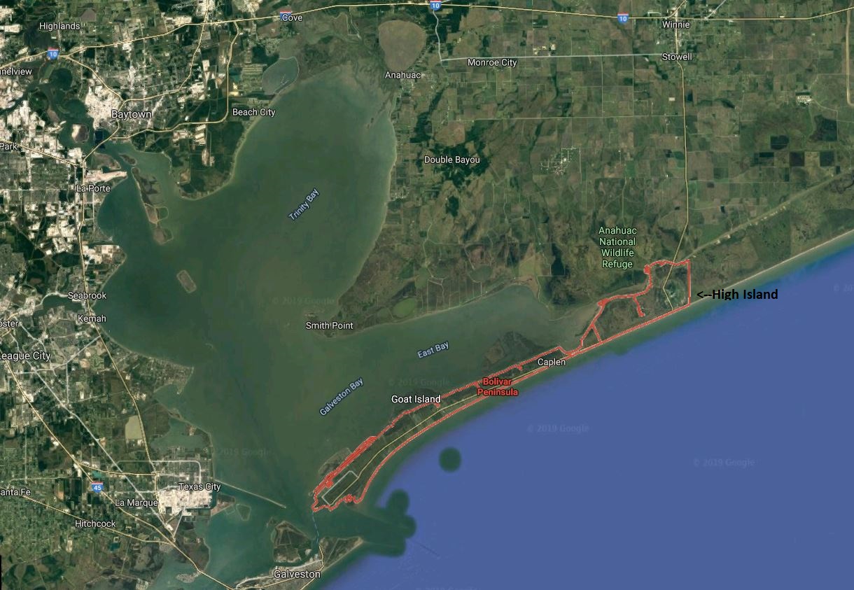
Noon Bird Walk.  After a short briefing from the guides at noon, we piled into our cars and followed them down the peninsula to our birding destination, Rollover Pass.  Rollover Pass is about halfway down the peninsula and is the narrowest portion of the peninsula, only about 0.3 mile wide.  According to legend, it was first called Rollover because certain early ship captains preferring to avoid contact with the customs station at Galveston would roll barrels of imported merchandise from the gulf side of Bolivar Peninsula over to East Bay. From there the barrels were transferred to the mainland.

Rollover Pass is also the location of a cut through the peninsula made by the Texas Game and Fish Commission in 1955.  The 200 foot wide, 5 foot deep, 1,600 foot long channel was, according to the plaque at the site, "to introduce into East Bay sufficient quantities of sea water to increase bay water salinity, and to provide additional opportunity for travel of marine fish to and from spawning and feeding areas in the bay." 

The normal travel time to Rollover Pass from High Island is 20-30 minutes.  It took us a bit longer due to construction along the road, Texas Highway  87.  Being only a single two lane road, it meant traffic was reduced to one lane with a flagger.  However, it was the most enjoyable wait for road construction you could imagine since it was right on the ocean.  It appeared to us they were only resurfacing the road.  However, research after we got home indicated they were raising the road from its current elevation of 5.5 feet above sea level to 7.5 feet so that it is less prone to flooding during storms or just high tides.  The state had already abandoned Highway 87 east of  High Island to Sea Rim State Park after it was largely washed out by Hurricane Jerry in 1989.  That is not an option for this much more developed portion of the peninsula that depends on this single road.

The tide was high when we arrived, so there were many birds of all sizes crowded on the shore.

This seemed like a large mishmash of "seagulls" until the guides worked systematically showing us how to identify quite a few different types.


What at first looked to our untrained eyes as a large mass of "seagulls", the guides patiently worked through pointing out at least two kinds of gulls and five kinds of terns.

More terns of various kinds with pelicans and cormorants in the background

Watching at other spots along the shore, we could also see two kinds of pelicans, various sandpipers, multiple kinds of herons and egrets, and an interesting new bird for me with their large multi-colored beaks, black skimmers.

Although we avoided getting really close, the birds did not seem particularly concerned by all of the people hanging around gawking. 

People watching the birds and the birds mostly ignoring the people

The smaller birds were resting while the herons and egrets were more focused on catching fish.


Great Blue Heron with a fish

After another quick stop we headed back to High Island for the last bird walk of the day, the Rookery at Smith Oaks.

Afternoon Photography Walk.  We arrived early at Smith Oaks and looked around a bit before meeting with the guides at 4 for what was billed as a Photography Walk, which is something new this year.

Our specific destination was the Rookery.  Since we were interested in seeing the Rookery and more interested in photography than birding, it sounded perfect.  It was to be led by the professional photographer among the guides, Ben Knoot.


Smith Oaks Sanctuary

Smith Oaks was nice with good boardwalks and very nice bird blinds, at least near the Rookery area.


The Frog at one of the blinds at the Rookery

However the Houston Audubon Society just announced plans for a multi-millionaire dollar improvement which will is scheduled to be finished by next spring.

So what is the Rookery?  The Rookery is an island in the middle of Claybottom Pond where thousands of large water birds such as egrets and herons nest.  The handout at the trailhead indicates at least ten different species of birds nest here: Roseate Spoonbill, Great Egret, Snowy Egret, Cattle Egret, Tricolored Heron, Little Blue Heron, White Ibis, Neotropic Cormorant, Anhinga, and Black-crowned Night Heron.  I think we saw at least seven of the ten species and got pictures of six.

This location is particularly attractive to the birds since the alligators in the pond prevent mammalian predators such as raccoons and coyotes from reaching the island.   According to this account on the Houston Audubon Society page, the development of the site as a rookery was not planned, at least not by the people.  Planned or not, the birds love it.  There have been as many as 13,000 birds on the small island at one time.  There were not that many the days we were there, but there were many.  It was stunning to see how many nests were crowded together, often of different species.

As described on the HAS website there is potentially much to see and hear. 

Every year is different but in an average year, nesting activity starts in March when Great Egrets start spending the day on the island displaying their gorgeous plumes to try to attract a mate. Snowy and Cattle Egrets, Little Blues and Tricolored Herons, White Ibis, Neotropic Cormorants and Spoonbills soon show up and things get real active and noisy. Herons and egrets don't exactly make calls but they do make a lot of different noises and as you are watching nest building you will hear some strange ones. Snowy Egrets make a noise that sounds like gargling -I don't know what it means but you only hear it when they are courting. Neotropic Cormorants oink and some days it sounds just like a barnyard. They oink year round so they not only use the oinking for courting they seem to oink as a greeting in the evenings when they come in to roost. By mid April lots of things are happening, early eggs are hatching, and nest building and displaying are in full swing and you can get a close look at all the activity from the trail around the pond. There is no where else in Texas where you can get such a wonderful look at the home life of colonial waterbirds.
When you visit the Rookery there are lots of the interesting things to watch for; like the stick hunt. With so many birds looking for sticks they are looking everywhere. Tricolors will hover over the pond and pick sticks up out of the water. Great Egrets will walk the trails. And everybody steals sticks from their neighbors when the neighbors aren't watching. Egg turning is another entertaining show. Eggs must be turned regularly to develop properly and some birds turn the eggs easily and quickly but for some it is a big production. Chick feeding, flight training and sibling rivalry are all fun to watch. Predation is also easy to watch but may not be enjoyed by all observers. There are always a few night-heron nests in the rookery and night-herons are predators. They regularly visit neighboring nests, grab unwatched chicks and take them back to their chicks. The other Rookery residents don't seem to pay much attention to the night-herons and aren't as protective as you would like them to be. The birds also aren't as careful around the alligators as you would like them to be. Since you can see the gators lying in the water next to the island you would suppose that the adult birds would see them also. But they wander right down to the shore for a drink and splash they are gone. So some of the show in the Rookery is not for those with a queasy stomach.
The show at sunset is something not to miss. Year round thousands of birds spend the night on the island in Claybottom Pond. This show starts about an hour before sunset when the first birds trickle in, soon it is small flocks, then big flocks then they pour in from all directions. From 1996 - 1998 Peggy Boston and I regularly counted the number of birds coming in to roost and it was a challenging spectacle to record. The night we had the most birds was August 30, 1998 when we counted 13,069. The birds in the sunset light is quite a sight.
I tend to forget I can capture video with my camera, but did take this short video the next day.  Unfortunately it was raining and there were fewer birds and they were less active so it did not capture the frenetic activity that was everywhere around us on Thursday.  This video also did not capture the pig-like oinking sounds of the cormorants which was so prevalent the day before.  Who knew!?  At least there were fewer people in the blind!


We watched a male Great Egret repeatedly bring sticks to a nest.  The female then very carefully positioned each stick exactly where she wanted it.

Great egrets building their nest.  The male disappeared for long periods then reappeared each time with a stick.  The female then took a long time to position precisely where she wanted it in the nest.


We were excited to see many roseate spoonbills.  They are beautiful from a distance, especially in flight, but we were surprised to see how ugly their faces were close up.


It is obvious why they are called spoonbills, but perhaps only a face a mother could love.


It was just the beginning of the nesting season, but at least one of the great egret nests had some little puff balls I could see in the nest when the adult stood up.


Momma tending to the little ones


I could not understand why she kept settling back down on the nest until looking at the pictures at home and realized not quite all of the eggs had hatched.


New baby Great Egrets.  Note the egg on the right that appears to be in the process of hatching.

With all of the things going on in and around the nests it was easy to overlook other birds in the foliage at the foot of the blind.


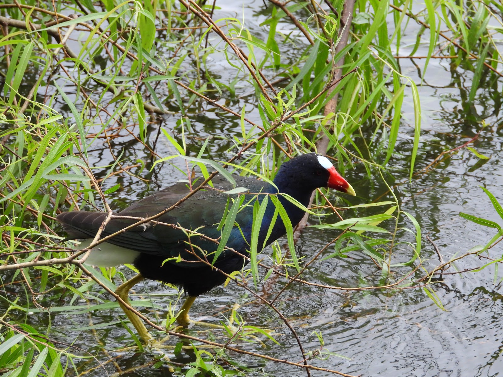
Purple gallinule just below the blind

After spending a very long time at the first blind, we made a quick dash down to the next blind before we had to leave. 

Part of our photography group with our red hat guide walking above the pond to the next blind

It was closer to the birds, but there were more trees in the way of many of the nests.  However, a highlight was seeing some slightly larger baby egrets.  They look so clumsy and so cute at the same time.


While walking down the trail we also caught sight of one of the resident alligators.  I am not sure I could stomach seeing them capturing baby birds that fall out of their nests, but I am glad the alligators are there to scare off the raccoons.


It was unfortunate this was at the end of what had been such a long and busy day because I was getting very tired.  Still I think watching all of the activity at the Rookery was probably my favorite part of the trip to High Island. It was a fantastic end to a great day.  For all of the things we saw today (or at least got pictures for and could identify) see this page on iNat.

Wednesday, April 24, 2019

Trip to High Island Day One -- Anahuac NWR

We left home a little after 9 am on April 10.  The traffic was not too bad except for some slow spots near downtown Dallas.  We were pleasantly surprised by the much larger percentage of I-45 between Dallas and Houston that is now three lanes both directions compared to twenty years ago when we were driving that route much more frequently.

Our destination for the day was Winnie, Texas, a small town on I-10 which is 19 miles due north of High Island.  High Island has only one small, very aging motel.  Apparently no motels have been rebuilt on Bolivar Peninsula since everything was destroyed by Hurricane Ike in 2008.  However, there are multiple motels, including several new ones, in Winnie so Winnie it was.

We had debated about the best route around Houston.  After checking the traffic during our lunch stop, we decided to take Beltway 8 around to I-10.  I am not sure why Google Maps thought 610 was better, but this could not have been easier.

Before going to Winnie we stopped at the Anahuac National Wildlife Refuge Vistor's Center which is just off I-10. 

The Visitor's Center is just off I-10.  The actual refuge is the green area off FM 1985.  Although it looks like it on the map, there is no access from SH 87 or SH 124.

We spent quite a bit of time checking out their informative displays.  We also each got some cool souvenirs, a hat for the Frog and a t-shirt for the Turkey.

Souvenirs from Anahuac NWR


Fortunately we got detailed instructions on how to get to the refuge from the Visitor's Center, which is many miles (and multiple turns) closer to the coast.

We did not know what to expect at Anahuac.  Although there were several trails, to get the feel for the place we spent the entire time in the car.  We did both the long drive (~6 miles one way from the information kiosk) down to the water (East Bay).  We also did the shorter (2.64 mile) one way auto loop around Shoveler Pond.

Map of Anahuac NWR, although the scale of miles seems wrong.  The distance from the Visitor's Kiosk (? on the map) to the southern most point on Frozen Point Road was about 6 miles one way.


We saw many interesting things.  Some were of things that are familiar to us at home, such as egrets and herons. 

Snowy egret
We were particularly intrigued by so many common gallinules, otherwise known as moorhens.  They were new to us.  Their bright red "noses" really made them stand out.


Common gallinule or moorhen.  Note the feet under the water.  They were not what I would have expected for a bird that spends so much time in the water.

There were also lots of ibises.  (Is that the plural of ibis?)

White-faced Ibis

Of particular interest to us was a totally new bird, the many very beautiful black-necked stilts.


Black-necked stilt


We also found the caracara nest on the water tower as described by the worker in the Visitor's Center.  Without trees the birds have to use what they can find.  Unfortunately there were no birds, at least when we were there.

The pile of sticks on the platform is reportedly a Crested Caracara nest, but there were no birds today.  The water tank was for cattle that were grazing in this field.
We then made our way to High Island and found the kiosk at Boy Scout Woods, the location of the tour in the morning.  It was too late to do anything, but at least we knew where to go the following morning.

Then it was back to Winnie and the motel.  I am not sure it was true, but the person at the front desk made it sound as if Al-T's Steakhouse and Seafood was the only restaurant in town so we ate the first of several dinners there.  It may not be the only place in town, but it was certainly busy, both with locals and lots of obvious out-of-town birder types. 

Trip to High Island -- Intro

Trip to High Island...and a whole lot more.  It has been over a week since we returned from five days for a nature trip along the Texas coast, or what is commonly referred to there as "birding tourism".  Although we are novice birders at best, it was a very interesting trip.  We did not see many of the small migrating warblers we expected, but that was more than made up for by an up close and personal encounter we had with two large birds--two whooping cranes!  I never expected to see them in person in my lifetime.  There will be more on them to follow in a future blog.

Two whooping cranes in a rice field northwest of Winnie, Texas.  Each bird is over five feet tall.  Note the colored bands and the radio transmitter visible on the left leg of the bird in front.

As is usually the case for me, I also learned a lot about some new locations, including some interesting history.  Unfortunately I am just now getting to writing this blog. 

Observations on iNaturalist.  "What took you so long to start the blog?" you may be thinking.  Well, most of my spare time over the last week has been pouring over the nearly 3000 pictures we took on the trip and getting the critters (and some plants) identified and posted as observations on iNaturalist.  Some were similar to the types of things we see and recognize at home but others were totally new to us.  Observations for each day are at these links.  Click on individual pictures within each link to see the actual observation details.  April 10, April 11, April 12, April 13, April 14.

What is High Island and why is it special in the birding world?  High Island is an unincorporated town of several hundred people (500 in the 2000 census, but probably fewer now) on the eastern end of the Bolivar Peninsula.  Bolivar Peninsula is a narrow strip of land, really a barrier island but connected to the mainland on the east end, that is east of Galveston Island.  The southern boundary is the Gulf, while the northern boundary is the Intracoastal Waterway (ICW) and Galveston Bay.

Satellite view of Bolivar Peninsula (outlined in red).  The round feature that almost fills the large eastern end of the red outline is High Island. 
In driving around the entire region it was obviously very flat, but that did not completely hit home to me until I saw a tall structure in the distance as we were driving south along Texas Highway 124 towards High Island from Winnie.  It stood out since there were so few landmarks.  My first thought was that it was a grain elevator in the distance, certainly a common sight in Texas.  No it was not. It was the bridge of a tugboat pushing a barge along the ICW. It is always a bit disconcerting when you feel you are looking up to see boats.

Lots of flatness and no landmarks.  We were unfamiliar with the grasses, but they were very tall.  The grasses here were not nearly as tall as in other fields, but were still nearly the height of the fence posts.  Taken from the road in Anahuac NWR. 
I also did not realize how much water was in some of the fields until we were looking down from the height of the 124 bridge that goes over the ICW a few miles north of High Island.

High Island also refers to the fact that the town sits on a salt dome which is about 1 mile in diameter and 38 feet high.  This makes it one of the highest points along the Gulf Coast between the Yucatan Peninsula and Mobile, Alabama.  For comparison, most of the remainder of the Bolivar Peninsula is only about five feet above sea level. It truly is an island at those times when hurricanes hit the region, which is all too often.  The region between Freeport (just south of Galveston) and High Island averages being hit by a named tropical storm once every eight years. 

The importance of the height from a bird's perspective is the presence of trees.  The higher elevation makes it one of the very few locations in the region where trees can grow.  The water table is just too close to the surface every place else for trees to survive.

Migrant birds from Central and South America make the spring migration north across the Gulf of Mexico from the Yucatan Peninsula to the Texas coast, a trip of 600 miles. Under favorable conditions the birds leave Mexico just after sunset (traveling at night to avoid predators) and head north across the Gulf.  High Island is an oasis of trees for small birds such as warblers after the long journey over water.


Scarlet Tanager chilling across the street from Boy Scout Woods Sanctuary on Thursday morning. 

Recognizing the unusual (and critical) nature of High Island for the migrating birds, the Houston Audubon Society began assembling land on High Island in the 1980's.  HAS has continued to acquire land and has established multiple bird sanctuaries in town as well as several along the shore on Bolivar Peninsula.


Fallout.  With good weather the trip across the Gulf takes typical warblers about 18 hours.  Arriving on the Texas coast midday some of these birds will stop on the coast, although many will continue inland until nightfall.  However, conditions occasionally exist where strong north winds and rain trigger a phenomenon called "fallout."  The wind and rain slows the birds trying to make the crossing, causing them to rapidly use up their stored energy. Thousands of tired migrants seek shelter and food as soon as they reach the coast.  At times the numbers of birds are so great they fill the trees and nearly cover the ground.  According to the Houston Audubon Society website:

During a typical fallout, Houston Audubon sanctuaries are used by the majority of species of the neotropical migrants that nest in the forests of eastern North America. Often, more individual species are found here than could be found in several thousand acres of prime Appalachian forests. For birdwatchers, fallouts can provide an exceptional birdwatching experience, as the birds are very tired and hungry and seem oblivious of humans.
Needless to say, we did not experience a fallout while we were there.  In fact, even the veterans commented repeatedly about how few birds they were seeing.  We did not care.  It was all new to us and we were having fun.

Saturday, April 6, 2019

Dallas Morning News Printing Plant Tour

We continued on Friday with our staycation activities sponsored by the Dallas Morning News.  The DMN is offering a number of activities as outreach for their subscribers.  This was a tour of their huge printing plant on Plano Parkway in Plano.  It was a really great tour, but I did a terrible job with pictures so this blog does not do the tour justice.


The Dallas Morning News was founded in 1885 and still publishes a daily morning paper.  However the number of papers printed is only about 90,000 per day, down from a high of over 600,000 several decades ago.  I don't know how many online subscribers they have.  Their Wikipedia page says they have almost 272,00 subscribers, so the differences might be online subscribers.  In any case, this tour was about the print part of the business.

What I did not know was that the Plano printing plant also prints regional editions of the New York Times, the Wall Street Journal, USA Today, the Fort Worth Star-Telegram and the Denton Record-Chronicle. Until last week, they also printed about 25 smaller commercial customers and weekly newspapers including the Dallas Observer and Fort Worth Weekly, some local college newspapers and suburban papers.   Those were dropped effective at the end of March as a cost-cutting move.  For that reason nothing was operating when we were there Friday morning...probably a good thing for our ears, but I would have loved to see the presses in operation.

There are seven printing presses at this plant and they are HUGE.  They are at least three stories high each, and I suspect each "story" is more than normal height.  There is one press for each of the newspapers because they use different width rolls of paper.  The "extra" press functions as a backup for any potential crisis. 

A portion of each press handles each section of the paper, i.e. the sections are printing simultaneously.  The pages of each section are cut and folded by the machine, but the sections are put together by the carriers at one of the several (5?) distribution centers. The presses can do some color pages, but they do not do the colored inserts here.

One of the rolls for the New York Times (note NYT in red lettering on side).  Another roll is mounted in the ready position on the press in the back but not actually feeding through the press.  When the active roll is nearly finished, this roll will rotate into position and the blue tape on that roll will engage with the paper on the active roll, allowing the paper to begin feeding into the press.
 
These are rolls ready to move into position on the press.  The track in the foreground is for the little dollies that move them around.  The different width rolls are slightly different weights, but the tag on the NYT roll said 1678 pounds.

The paper rolls are brought in by rail car.  They keep about a month's supply of paper on site. I was impressed by how high they were stacked (5 or 6 high) given that they each weigh nearly 1700 pounds.

Some of the rolls stacked in the warehouse.
I was a little confused about the timing issues, but it was roughly like this.  The printing plant receives the fully laid out pages (from whichever newspaper) as pdf files each evening.  Cutoff times vary with each newspaper, but the cutoff time for DMN (which has the latest cutoff) was about 10:30 pm I think.  That could go later when something newsworthy is happening late, such as a late Cowboys game. 

The pdf files are used to "burn" a flexible aluminum plate for each page of the paper (or 3 additional  plates, one each for blue/red/yellow, if it is a color page).  The aluminum plates are the same size as the page and fit around a roller on the press.  They actually make two plates for each page (or eight total for each color page), since two copes of the same page are printed simultaneously. 

Most of the process to create the plates is computerized, but each plate still goes through a chemical "fixing" process.  Each aluminum plate is used only once and is then sold for scrap.

The press run (at least for the News) usually starts sometime before midnight.  They currently run only one press for the News (used to be 2).  Once up to speed, the press can produce 45,000 - 50,000 papers per hour, although there is typically a loss of 5% or so at the beginning as they get everything aligned correctly.

Once printed, the papers are immediately loaded onto trucks to take to the distribution centers.  The last of the papers produced goes to the distribution center in the basement of the printing plant.  The goal is for the papers to be to the centers by 1:30 am.  It takes the carriers several hours to put the sections together, bag the papers, and load their cars.  The carriers then leave, with the goal of the papers being on front lawns by 5:30.

It was truly fascinating, but I am glad we saw it when we did.  I worry print newspapers may not be around much longer.

Monday, April 1, 2019

A Day at the Races

We spent most of Saturday at the races.  No, it was not Ascot or even Churchill Downs, but Texas Motor Speedway for a NASCAR race and in a luxury suite no less!!  We saw some qualifying runs, practice runs, and the main event of the day, the My Bariatric Solutions 300 NASCAR race.  Admittedly this was in the xfinity series of NASCAR, which is essentially the "minor leagues" of NASCAR.  The regular NASCAR race was Sunday afternoon and the truck race was Friday night.  However, the xfinity series was just fine with us because we are not NASCAR fans anyway.  It was just fun being there and taking in everything.


What??!!  You went to a NASCAR race??!! As I related our plans to other folks before our adventure, people tended to fall into two camps, either (1) Wow, that is awesome, or (2) Umm, I won't insult you by saying it out loud but you could not pay me to do that.  Given that we are not even NASCAR fans, how did we end up there?  Well, of course there is a back story, if only a minor one.

We are longtime Dallas Morning News subscribers.  DMN contacted the Frog, whose name is on the subscription, and gave him the opportunity to enter a drawing open to subscribers with a variety of different prizes.  Lo and behold we won two tickets in the Dallas Morning News' luxury suite to the My Bariatric Solutions 300 NASCAR race on Saturday, March 30. Also included was VIP parking, continental breakfast (or at least sweet rolls) and lunch.  It was wonderful.  We really had a great time. 

Small crowd.  Texas Motor Speedway is a 1500 acre speedway located in very far north Fort Worth.  In fact, it is so far north it is in Denton County.  Based on an estimated capacity of over 181,000 fans, it is the second largest sporting venue (based on capacity) in the U.S.  However, due to the horrible weather, the crowd on Saturday was very small.


Front straightaway with pit row to the right as seen from our seats.  Although this was before the race, it was obvious the crowd was going to be tiny.


A blue norther had blown in that morning.  It was COLD and overcast made even worse by an incredibly strong north wind.  I don't know about sustained winds, which were significant, but the weather person on TV later said the gusts were to 40 mph.  Under normal conditions it would have been fun to explore the many vendor booths set up outside, but it was just too cold and windy. Thank goodness for being in a suite!

Great views of everything.  According to NASCAR it is a 1.5 mile quad-oval track, although IndyCar apparently thinks it is 1.44 miles...whatever.


We were on the first of two levels of suites very near exit 6 on the map above.  They were great seats near the end of the front straightaway just before turn 1.  We could easily see the entire track and the large video screen, "Big Hoss", on the other side of the track.  We were amazed at how much easier it was to follow the race compared to watching on TV.  There was also tv coverage in the suite, although we could not see the monitors very well since we chose seats all the way in the front.


Some of the cars during practice for Sunday's race.  Big Hoss is on the right.  Turns 3 and 4 are in the distance.  Pit row is in the center, with the main straightaway on the left.


Turn 1 and turn 2 (south end) during practice.

It was amazing how fast the cars moved, especially during the qualifying rounds.  According to the display on Big Hoss, the top qualifiers were all going in excess of 190 mph.


I was impressed with the speeds especially since these were xfinity Series cars, which according to someone sitting behind us have smaller engines and 200 hp less than the regular NASCAR cars.

One of the other major differences to seeing the race on tv was the color of the cars.  It was obvious how useful that was to identifying them from a distance.


For that matter, there was color everywhere despite the drab, gray day.

All the pit crews lined up for the singing of the national anthem.

Some of the different track support personnel (ambulance drivers, wrecker drivers, etc.)

 
It was also interesting to see all of the many different support vehicles, some of which I still don't understand.  One vehicle looked like it had a large magnet on the back, but I somehow missed getting a decent pic.  All of these services and more had to be in the right place at the right time and people fed since it was an all day event.  The logistics in putting on this type of event is staggering.


Handing out box lunches to the support personnel in the downtime between practice runs and start of the race.

If the weather would have been better, people watching would have been interesting.  At the very least, we saw the ferris wheel and some unusual vendor trucks.


The ferris wheel looks small from here, but is actually quite large.


Of course the main attraction was the race itself.  Car number 20, driven by Christopher Bell had the pole position and led most of the race.  Shown below is one of his pit stops.  Note in particular how fast each of the five lug nuts on each wheel is loosened and tightened, one "jab" each.


There were the smattering of various accidents.  For many it was a matter of pulling loose parts off the car and sending the driver on his way.


Pulling parts off the car and out of the tire well before going back on the track.


Checking things out after an altercation with another car.  Note the tire marks on the side of the car.


Of course some wrecks required towing the cars away, even as the other cars kept circling under yellow.


Support vehicles around the damaged 07 car


Car #74 passes on the high side as the wrecker attaches to the wrecked car.

The restart after a yellow was always exciting, with much maneuvering for position.


The final victor was Kyle Busch, who was actually a "major league" driver who was running in the xfinity series.  He had also won the truck race the night before.

Number 18 doing circles after winning the race.

However, I have to point out that #74 was the Frog's favorite car.  He had many more pit stops than most of the rest of the field and he was noticeably slower which meant he kept getting lapped, but he was still running at the end!


Our favorite car because he was at the back and kept getting lapped.


As I hope you can tell, we had fun and learned quite a bit about NASCAR racing that was largely unknown to us before.  Thank you Dallas Morning News!


Race Results per ESPN:
POSDRIVERCARMANUFACTURERLAPSSTARTLEDPTSBONUSPENALTY
1Kyle Busch18Toyota200533000
2Tyler Reddick2Chevrolet20031948130
3Christopher Bell20Toyota200112750160
4Chase Briscoe98Ford2001503300
5Jeb Burton8Chevrolet200603640
6Michael Annett1Chevrolet2001303100
7Justin Haley11Chevrolet2001103220
8Jeffrey Earnhardt81Toyota2001402900
9John Hunter Nemechek23Chevrolet200803020
10Ryan Sieg39Chevrolet20019837100
11Austin Cindric22Ford200903040
12Justin Allgaier7Chevrolet200403380
13Noah Gragson9Chevrolet20016133060
14Josh Williams36Chevrolet2002202300
15Ronnie Bassett Jr.90Chevrolet1992302200
16Ross Chastain4Chevrolet1991803090
17Brandon Brown86Chevrolet1992102000
18Kaz Grala21Chevrolet1981201900
19Tommy Joe Martins99Toyota1982401800
20David Starr52Chevrolet1983101700
21Gray Gaulding08Chevrolet198200000
22Stephen Leicht01Chevrolet1983001500
23Chad Finchum42Toyota1973501400
24Joey Gase35Toyota1963701300
25Vinnie Miller78Chevrolet1963401200
26Jeremy Clements51Chevrolet1961701100
27Matt Mills5Chevrolet1942901000
28Tyler Hill66Toyota191330000
29Mike Harmon74Chevrolet189360800
30Josh Bilicki93Chevrolet184260700
31Garrett Smithley0Chevrolet160380600
32B.J. McLeod15Chevrolet138280500
33Brandon Jones19Toyota133201170
34Cole Custer00Ford1327013100
35Ray Black Jr.07Chevrolet79250200
36Brad Keselowski12Ford68100000
37Timmy Hill13Toyota20320100
38Jeff Green38Chevrolet16270100