Friday, December 29, 2017

A Santa Barbara Christmas

Wow...what a fantastic Christmas with family in Santa Barbara!!! 

Maybe it felt especially sweet since even up to the day we left, I was fearful we would not be able to go given several potential issues. 

What kinds of issues?

As I mentioned in the previous post, I face planted into the sidewalk on Thursday, December 14.  My black eye  (or perhaps more accurately my purple, yellow, and magenta eye) got worse.


Monday, 12/18, before the blood began to pool in large amounts below the eye, but you get the idea


With mostly just a sore nose, a sore knee and lots of scrapes, I decided to ignore it.

The bigger issue was the Thomas Fire in southern Cal.  The fire started on December 4, miles to the east of Santa Barbara, but it kept creeping westward.  Then on Saturday, December16, it became a wind-driven monster on its western flank.  Nearly all day Saturday we helplessly watched live coverage on the Santa Barbara tv stations via the internet as the fire threatened homes in the region. 

Cal Fire Progression Map of the Thomas Fire (from Wikipedia) as of 12-25-17.  See https://upload.wikimedia.org/wikipedia/commons/thumb/a/af/2017_12_11-08.57.46.111-CST.jpg/1280px-2017_12_11-08.57.46.111-CST.jpg for a full size map.


Evacuations were ordered, including most of Montecito and parts of Santa Barbara, but the kids' home was not in the evacuation zone.  However, any further movement of the fire westward and they almost assuredly would need to evacuate.  Evacuation orders for their neighborhood are not to be taken lightly.  Most of their neighborhood, including their house, burned in 1990 as part of the Painted Cave Fire.  

Though not evacuating and still ten miles or more from the fire, they were feeling the effects from the severe smoke and soot.  Face masks were routinely needed while outside and HEPA filters helped the quality of air inside.  Even after we arrived days later, we spent very little time outside due to everything covered in soot and ash.

Note the soot and ash on the leaves of this plant, what I think is Angel's Trumpet


Even as as the wind died down on Saturday night, the fire was still very active and there was nothing to keep it from moving westward.  Fortunately the light winds lasted for several days, giving the fire fighters a chance to build fire breaks and dump water on the hot spots.  

The next big test of their containment efforts would be Wednesday night, December 20, into Thursday morning.  That was awful timing for us, if we needed to decide whether we could still go or not, since our plane left Thursday morning.  However, we crossed our fingers and continued preparations to leave, including adding N95 face masks to the stuff we were taking.

By the time we needed to leave for the airport on Thursday morning, we knew the fire lines had held so it seemed all was well.  Indeed, while we were in route, the evacuation orders were lifted.  It was still a monster sized fire, eventually becoming the largest California fire in modern history, but at least it was mostly in the back country and no longer a threat to homes in Santa Barbara.


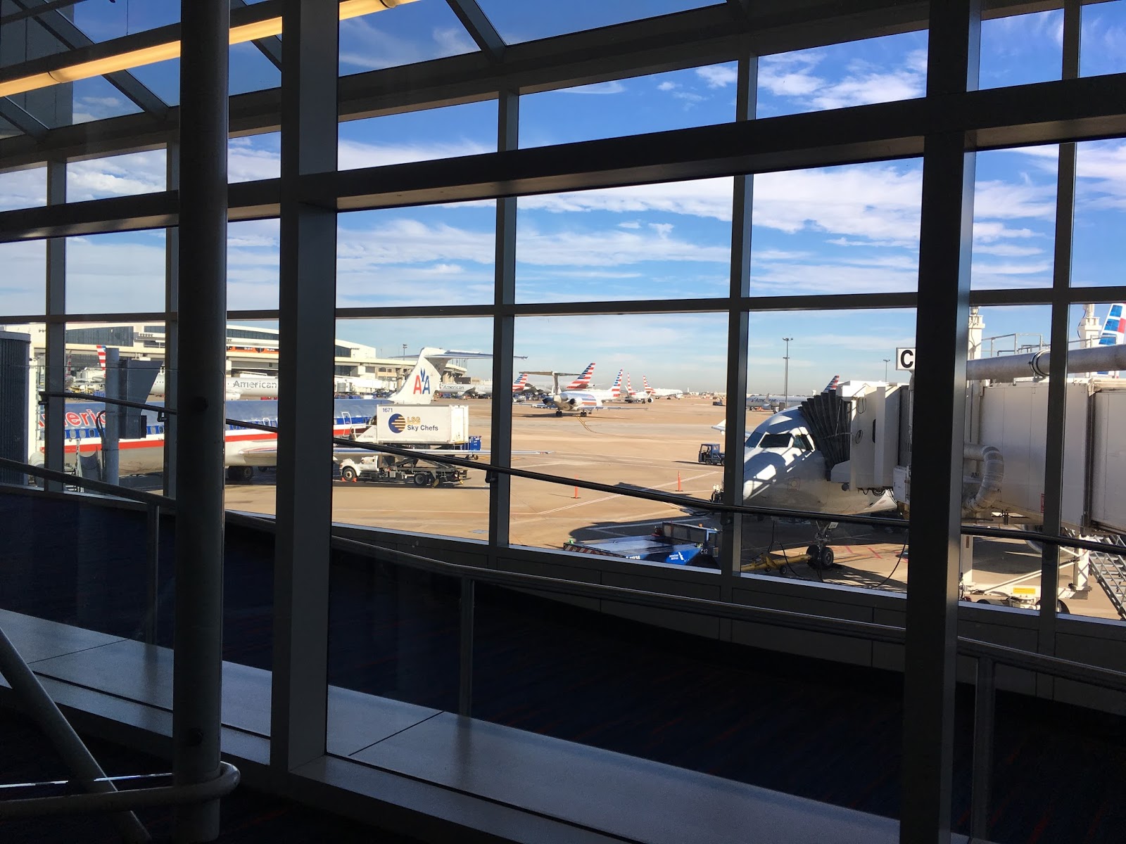
Lots of blue sky and sunshine on a 70 degree day at DFW

The flight was uneventful.  Since we fly so infrequently, we feel pretty clueless about current airline and TSA requirements. That adds to the stress.  Fortunately it was a direct flight from DFW to SBA.  It was a beautiful day and we even lucked out with no one next to us, so the two of us could spread out over three seats.  Yea! 

It is always so much fun to visit with the kids.  In addition to preparing exquisite gourmet meal after gourmet meal, they did all of the Christmasy things like cookies.  Despite all of the extra hassles due to the fire, they had their tree up and decorated...much to the consternation of Byron, who was concerned about the "indoor bush".

Gwen making gingerbread men.


Much of their life revolves around their SCA (Society for Creative Anachronism) activities.  Gwen is an expert on many (and I do mean MANY) medieval arts and crafts, as well as period clothing.


Paul continues working on his SCA brewing activities.  He was busy starting multiple batches of hard cider.(the beginning of a multi-month project). He is already an experienced brewer, well practiced in making many kinds of beer. 

Paul beginning the cider project. 
While we were there he began work on soapstone molds to make pewtar blanks.  The blanks will eventually be struck into pewtar coins.

Although probably less so than its public image, SCA is also about battle re-enactments and sword fighting.  That requires lots of training (hence Paul's current weight lifting program with kettle bell weights) and lots of specialized equipment.

Paul with chain mail and helmet

It was fascinating to learn the details of all of these many different projects.

But there is more. 

We had fun watching the many hummingbirds in their backyard.  One of the hummingbirds spent hours sitting in an avocado tree keeping watch.  He was quite territorial and was continually chasing the other hummingbirds that approached the feeder or even the backyard.   

Early one morning looking out the back.  The dot in the center of the red circle is the hummingbird sitting in his designated spot in the avocado tree.

But that was not the only thing to watch from their backyard. 

We are all geeks at heart in our family, so we were very anxious to see the launch of a Falcon 9 SpaceX rocket from Vandenberg Air Force Base.  The south end of Vandenberg, where this launch took place, is about 50 miles WNW of Paul and Gwen's house.  The rocket was expected to travel nearly due south, taking it out over the Pacific Ocean.


Lift off was scheduled for Friday, December 22 at 5:27 pm, which was about half an hour after sundown.  Although Paul and Gwen had seen multiple launches, including several at night, the Frog and I had never seen one.  I don't know what I expected, but what we saw was certainly different than anything that I had imagined.  

First of all, it was much larger and easier to see than I expected.  The initial first stage was a large orange fireball.  Unfortunately, I was so excited about seeing it, that I initially forgot to take pictures.  Then, as it went higher and further south, it arched across the sky in front of us.  It was easy to see the separation of the first and second stage. 

Falcon 9 rocket.  Bright object on the lower left (just above the tree) is the moon, I think. This does not truly capture how spectacular the launch was since it was just with my phone, but you do get a sense for how easy it was to see.


As it turned out, this particular launch was unusual even for those experienced in seeing such things.  Even though it was rapidly getting dark on the ground, since it was just after sunset the gases emitted by the rocket created a cloud which was still lit by the sun.  It made it unusually spectacular.   There was also lots of maneuvering around of the different components (different rocket stages?) in the sky, but I wasn't totally clear what I was seeing.

Gases shooting out and expanding around the rocket

The Frog did a rough calculation in his head as we were waiting for liftoff (once a physicist, always a physicist) that it would take 4-5 minutes for the sound of the liftoff to reach us.  Sure enough, just as the rocket was leaving our field of view and we were getting ready to go in, we began hearing a low rumble much like thunder.  It was definitely the sound of the rocket as it took off.
 
This article in Popular Science addresses why this launch looked so strange even to experienced observers.   This article, although listing the wrong date, does have lots of detailed info and additional pictures from the launch site.  I especially liked this reply in the comments of the second article to why this looked so unusual:

When the second stage engine fires, it's in a near vacuum, so the exhaust plume expands very widely (without significant air resistance to push it behind the vehicle). I recall seeing this many times, on Apollo and Shuttle launches, during second stage (for Apollo) or post-booster separation (for Shuttle), but images from near the launch site only capture the plume from behind. The huge teardrop shape is the appearance of the plume from a vantage well away from the launch point, where the side of the contrail and plume become visible -- and it's a viewpoint neither NASA or SpaceX has ever shown us.

Of course, this would be hard to capture anyway on a Canaveral flight, with an eastward launch over the Atlantic and the launch corridor cleared for safety (might be visible from Bermuda or the Bahamas). Polar orbit launches from Vandenberg, by contrast, fly southward near the California coast. Add to that, this launch climbing into sunlight just after sunset for southern California, and the clear weather, and you have the formula for a never-before-photographed, but very common phenomenon.
Seeing this was absolutely spectacular.  I am so glad we got to see it. 

It was hard to leave, because I know it will likely be a long time until I see Paul and Gwen again.  At least my Christmas cactus was in the Christmas spirit and was a bright addition to our return.

My Christmas cactus, which is at least 15 years old.  Great to see it blooming like this!

I was glad to see that my moving it to a location where it had more darkness in the evenings had encouraged it to bloom!  BTW, a new factoid I stumbled upon recently: according to Neil Sperry, Christmas cacti naturally grow suspended from tree trunks in the upper canopy of tropical rain forests of South America.  Who knew???!

Well, this turned into a much longer post than I had anticipated, but it was an eventful several days.  Most of all, it was so great to be with family for Christmas.  Thanks Paul and Gwen for putting up with us.  I truly had a very Merry Christmas.

Friday, December 15, 2017

Rudolph Impersonator

You would think I would learn.  I was going to post about the peppers and cucumbers I was able to harvest from the garden on December 7 before the major freeze into the low 20's that killed the hot weather plants (peppers, cucumbers, and tomatoes) on December 8.

This is the December 7 harvest to beat the hard freeze on December 8.  It includes 2.5 lbs of ripe banana peppers (the second such batch I have harvested in a two week period, with almost that much unripened on the plants) 0.5 lb of cucumbers, and plenty of lettuce.


Not a bad harvest from my little garden for December!  From the cucumbers, I was able to make another small batch of bread and butter pickles, which are so much better than the pickles from the store.


Lots of little ones that I picked early due to the impending freeze.


Not quite a full jar, but not bad for December.


I don't know if I will pickle the large numbers of banana peppers, since I already have many more of them than I will probably ever eat and I am short on time.  There are lots of other things that take precedence this time of year.


But, haste makes waste.  Running around trying to get everything ready for Christmas yesterday I was not paying attention, misjudged the curb, and did a face plant into the sidewalk in one of the strip shopping centers in Highland Village. 

Morning after pic


I now need to add a trip to the glasses store to at least try and get these bent back into shape.  I will also need to start the process for new glasses, since the left lens is scraped up.


Good news:  I seem to be ok, despite bending my glasses and scraping my face, hand and knee.  I am not as bruised this morning as I was afraid I would be, but that may get worse before it gets better. This is just a heads up for those of you that will see me at Christmas.  I will be "Rudolf the Red-Nosed Turkey".


Friday, October 20, 2017

LLELA Adventures

We have been having lots of fun observing nature while hiking the trails at our local nature preserve, Lewisville Lake Environmental Learning Area or LLELA.  The combination of hiking on easy but interesting trails and the large diversity of critters for the Frog to capture with his camera has made LLELA the perfect place for us.  However, it has turned into so much more than just a place to walk and shoot pictures.

LLELA's new Information Center

LLELA has not had any kind of permanent activity/nature center for the general public.  That changed recently with the opening of the new Information Center earlier this month.  This is a temporary, although perhaps multi-year, solution.  The current center is an "Information Center", not to be confused with a planned permanent nature center possibly built in cooperation with the National Audubon Society.   However, that may have to wait a few years for road construction and other improvements.

The new Information Center is in one of the portable buildings donated by LISD.  It is currently only open 9-4 on Saturdays and 1-4 on Sundays.  We went through the volunteer training two weekends ago and actually manned the center last Saturday, 9-1.

The Information Center is still a work in progress, but it was fun volunteering.  It does not look like much from the outside, especially since the permanent welcome sign is still on order, but it does have air conditioning and indoor plumbing.

The entrance to the Information Center with my homemade sign to let people know they could/should come in.

There are a few displays inside.


There are also some hands-on items to feel and touch:  beaver skeleton, alligator gar skeleton, bird's nest, etc. and a sandbox with molds to make animal tracks such as raccoon, deer, bobcat, and coyote. 


There is a very nice wall size map of all the trails at LLELA.  That came in very handy, since most of the folks that came by were interested in learning what trail they should take.  We are very happy to talk extensively about the trails since we walk the trails (weather permitting) at least once a week and often more.


However the best part of the Info Center by far, at least in my opinion, is the picture wall.  It is a collection of pictures of various animals, including insects, taken at LLELA.  These were the same pictures that were on display at the Lewisville Public Library during the month of August and include several of the Frog's pictures. 

Picture wall in the Information Center

Almost everyone that came in was surprised at the wide diversity of animal life that had been observed.  People seemed to especially enjoy the bald eagle, the bobcat, and some of the snakes.  However, the one that generated the most interest, hands down, was the alligator. 


Even More Excitement

As exciting as volunteering in the Info Center was, that was not even the high point of our LLELA experience that week.  On one of our walks we observed a damselfly whose identity has totally baffled the dragonfly/damselfly experts nationwide.  Yes, really!

Here is the story.

Having Fun with iNaturalist

When we walk at LLELA the Frog takes pictures of the living things we see.  Once we get home, I post the pictures as observations on iNaturalist.

I cannot overstate how much iNaturalist has helped us learn about the nature we are observing.  It is helpful in at least two ways.

First of all, iNaturalist has built in artificial intelligence that provides suggestions as to the identity of the animal or plant in the picture. This is a brand new feature in the past few months, although the development of the software and hardware took some time.  As a user I can say it is stunningly good.  With a few exceptions the suggestions are usually spot on.  It is also very user friendly.  Each of the suggestions comes back with links to pictures, the specie's Wikipedia page, maps of where it has been sighted, and a list with pictures of species with which it is most often confused.  Such immediate feedback and ease in doing more research makes learning about the things we see a lot of fun.

Once the observation with picture, location, and possible identity is posted, volunteers respond to help with the identity.  They can agree, disagree, or make alternative suggestions.  I have also sometimes asked them questions and they always seem willing to respond.  The volunteers doing the identifying can be anyone, but are often experts in the field.  What is stunning is the speed of the responses.  For birds and dragonflies the response can often be within minutes or less.  Admittedly we are helping ourselves by providing first class images, but we could not pay for the help we are receiving from these people.

New Critter at LLELA?

So what does this have to do with anything?  On October 6 we saw this bright blue damselfly while walking on the Blackjack Trail at LLELA.  You cannot tell from these zoomed in pictures but he is very little, probably two inches long max.

Mystery damselfly

Mystery damselfy

He is not that different from many of the other bright blue damselflies we have seen, but the markings on his thorax and abdomen didn't quite fit with anything that came up as suggestions on iNaturalist or was shown in any of the books I have on damselflies.  That is no biggie...I frequently struggle with damselfly identification.  I just listed it generically and posted it to iNaturalist. 


Here is our posting on iNaturalist which I made at 3:45 pm that day:  https://www.inaturalist.org/observations/8286492  By the time I checked back (after dinner?) I had a response from one of the major damselfly experts indicating this guy looked interesting but he could not identify it.  He was contacting some academic damselfly experts for help.  They looked at it over the next few days and they could not identify it either.   Apparently this little guy had the damselfly experts baffled.  Yes, really!!


Familiar Dancer??

Several of the experts thought it most resembled an Argia oculata or common name "Familiar Dancer".  They were also very excited and were urging people in the DFW area to go looking for it to confirm the ID.

OK, all of this did not mean much to me so I began to do some digging.  I initially had trouble finding out much about Argia oculata.  The known range for them is Mexico, Central Amreica, and northern South America.

Location of iNaturalist observations for Argia oculata.  Although not shown, they also exist in other locations such as Columbia

It was not in my books about Texas damselflies or U.S. damselflies since it is not known in the U.S.  I finally found a Wiki page in Spanish (Argia oculata on Wikipedia). (BTW, one of the translating programs translated what must have been the Spanish for dragonfly to "horse of the devil"!)  I finally found one page of info in English:  description and pictures of Argia oculata.

One of the comments under iNaturalist on our posting indicated that if it really was an Argia oculata, it would only be the second sighting in the U.S.  That would be cool.  What I did not know was that the first sighting had only occurred in September 2017 and was in far southern Arizona along the Mexican border.  (See Arizona dragonflies page for Familiar Dancer  and Troy Hibbit's page on Argia oculata).

Needle in a Haystack

It was clear no one was going to be comfortable making an ID from pictures for a critter that was so far from its normal range, especially since there was still ambiguity in the appearance.  It would be necessary to catch the little guy and send it to the lab for inspection under a microscope.


The Urban Wildlife Biologist in Dallas/Fort Worth with Texas Parks and Wildlife organized a get-together for Saturday morning, October 14, to try and find this little guy:  https://www.inaturalist.org/journal/sambiology/12081-lewisville-lake-on-saturday-10am-dragonfly-hunting    Unfortunately it was during our time volunteering in the Info Center so we could not tag along.  All the folks that did show up (about eleven total, I think) did stop by the Info Center to say hi before heading out.

Perhaps to no one's great surprise, they did not find the Mystery Damselfly but they all seemed to have fun.  At least we got to meet a whole host of nice people, many of whom we knew from online but had never met in person.

Was it a Familiar Dancer?  We may never know, but it was an interesting exercise that was only made possible because of the online community of people linked together through this remarkable program iNaturalist. Thank you software engineers! 

Tuesday, October 17, 2017

Eclipse Trip -- Great Smokey Mountains National Park

One of the last things on this epic adventure, but among the first we had put on our to do list when first making plans, was the Great Smokey Mountains National Park.  We stayed overnight in Cherokee, North Carolina, then drove to the Oconaluftee Visitor Center, arriving just as they opened.

Mountain Farm Museum

The Visitor Center was fine, but even better was the adjacent Mountain Farm Museum, a working farm made of various turn of the century farm buildings that had been moved to the sight.  Unfortunately most of them were closed, but we had the whole place to ourselves so had plenty of time to walk around and check things out.  Well, we were almost alone.  Being there early did give us the opportunity to see some local wildlife, a ground hog.

Some of the farm buildings with the ground hog in the foreground

I could not tell for sure what it was in the middle of the open area, but as I tried to get closer for a shot with my cell phone it looked like a very chubby rodent.


The ground hog starts retreating as I try to get closer for a pic with my iPhone, but he doesn't seem too concerned
   I am not sure what ground hogs eat, but he looked very well fed.


Ground hog munching on something

I presume farms in this area, i.e. out in the middle of nowhere, at the beginning of the 1900s had to be largely self-sufficient.  This farm had pigs, chickens, apple trees, a vegetable garden, and a corn field. It was interesting to see how they even stored ashes for making soap.


I don't know if the other members of our family who are currently making soap use the floating egg test for strength of the lye, but it would be interesting to see how that aligns with using pH paper.  :)
 
Ash hopper

Mingus Mill

Our next stop was only a half mile up the road, Mingus Mill.  Mingus Mill is an operating gristmill.  The mill was completed in 1886 and is still in its original location.  In place of a wooden water wheel this mill uses a small steel turbine, making it one of the most advanced mills in the Smokey Mountains when it was built.


We enjoyed talking to the person on site who was grinding corn while we watched.  We bought a bag of cornmeal, but found out later it was actually ground in a similar mill in Pigeon Forge.  Apparently it is impossible to maintain the cleanliness standards required by the Health Department at this mill and also be able to demonstrate how the mill works to visitors.


I was also surprised to see the "Keep Refrigerated" listed on the bottom of the package when I went to use it several weeks later.  I guess that is because there are no preservatives.  Despite it not being refrigerated, I used it to make cornbread per their suggested recipe.  The cornmeal is a bit coarser and more irregular,especially in color, than what I usually see from the store, but I would not define it as "coarse".  I don't know if their recipe is typical of what would have been done at the turn of the century.  At the very least I would have expected them to use an iron skillet rather than a pan.  In any case, I had never cooked anything with real buttermilk before.  Whether realistic or not, the final product was very good. 


Elk

We enjoyed learning about the mill, but still had miles to go so we set off up the Newfound Gap Road.  We had only gone a very short distance when we encountered cars parked haphazardly and people running everywhere.  There was a sizeable herd of elk in the open meadow beside the road.

By the time we got stopped, the large male had moved back into the woods.

Huge male elk

However, the females were still munching on grass out in the open.

I thought these were cows, but is the one on the left with horns a young male??

The cows did not look abnormally large, probably like large deer.  However, the male was enormous.  I am not sure whether it was him or another male close by, but we heard one of the males bugling.  That was cool!

All of them eventually wandered out of sight into the trees, so we climbed back into the car and headed onward.

Clingmans Dome

One of the iconic images associated with Great Smokey Mountains National Park is the observation tower on Clingmans Dome.  Clingmans Dome is the highest mountain in the park and the third highest peak east of the Mississippi at 6643 feet.  The guidebook indicated that the observation tower at the peak allows access above the trees for a panoramic view out to 100 miles on a clear day.  Note that the operative phrase is "on a clear day". More on that in a moment.


Is it something we were capable of doing?  Clingmans Dome is at the end of the seven mile long Clingmans Dome Road followed by a 0.5 mile hike up to the summit.  I couldn't find out much ahead of time about the hike other than it is very steep.  We weren't sure what to expect, but the trail itself.  was listed as paved so we thought we would drive out to the parking area and check it out.

The weather below had been fine.  However, at the parking lot and above we were in a cloud.  The weather was not bad, but it was very damp and there was not much of a view.  We had come this far so it seemed silly not to at least try to make the trek to the top.  Upward we went.

Looking down the trail.  It doesn't look nearly as steep here as it felt on the climb up

As we made our way up the paved trail (actually more like a road than a trail) our legs were not tired, but we still had to stop multiple times.  We are not used to being at this altitude.   Even at the start of the hike we were at 6325 feet according to my gps. 


We just kept going and finally made it to the top of the mountain and then to the top of the observation deck.  At 6699 feet it was an elevation gain of 364 feet in half a mile.

The view was not great, but it was still worth the effort to get there.

View from the observation deck


Looking down on the trees and the ramp leading up to the observation deck
The forest at the top with its cooler temperatures and high rainfall is a spruce-fir forest, similar to what is found in central Canada.  It was obvious there were many dead trees.  A European inset pest was accidentally introduced into the U.S. about 1900 and first discovered in Smokey Mountains National Park about 50 years ago.  It has already killed more than 70% of the mature Fraser firs in the park.  

But I don't want to dwell on the bad things about this hike because overall it was very good.  One of the highlights was the opportunity to hike on the Appalachian Trail...at least for about 6 feet or so. :) 

Yes, the sign does say Appalachian Trail.  I guess it would be a more convincing pic if I were wearing hiking boots rather than tennis shoes.
On our way back down we really enjoyed all of the flowers along the side of the trail. 


 Some of them were attracting huge numbers of bees.

I don't know what this plant is, but the bees sure loved it.


I should add that we were very lucky to make it to the top of Clingmans Dome when we did.  I only found out after we returned home that the trail and the observation tower were supposed to close on Wednesday, August 23, and remain closed for the remainder of 2017 for repairs.  We were there on Friday, August 25, in blissful ignorance.  Fortunately the closure was delayed at least for a couple of days and we made it to the top!


 Lunch at Chimneys Picnic Area

We had had a full morning of adventures and we were beginning to get hungry.  Fortunately I discovered early on there would be no place to buy lunch once we got into the park.  Therefore we scrounged around the night before in Cherokee for the makings of a picnic lunch.  I had also discovered early on that Chimneys Picnic Area was considered by many to be the best picnic area in the park.  It was right along our route, so it looked to be perfect. 

Again we lucked out.  The name comes from Chimney Tops, a mountain nearby and the location of one of the most popular hiking trails in the park, although steeper and more difficult than what we would want to tackle with our bad knees.  As it turns out, the summit of Chimney Tops was where the huge fire started in November, 2016, that eventually devastated parts of Gatlinburg and Pigeon Forge.  A newly renovated trail has only very recently (October, 2017) been reopened.  I have since read that part of the Chimneys Picnic Area was burned in the fire, but we did not see evidence of that when we were there.  In fact, the only areas of fire damage we saw were some of the hillsides while while driving along Newfound Gap Road after leaving the picnic area.

Map from the Visitors Center showing the area of the 2016 fire


I really enjoyed our stop for lunch.  It is obvious from the layout that the Chimneys Picnic Area used to be a campground.  There are 68 picnic sites, with parking immediately adjacent to each site.  The West Prong of the Little Pigeon River runs through the picnic area, with some sites immediately on the river.  (I did not know there was a Pigeon River!  Guess that is where the name "Pigeon Forge" comes from.  Duh!)

Sorry...caught you with your mouth full.
Although the sign on the middle of the picnic table warned about feeding the bears, we did not see any.

Sign on the picnic table at Chimneys Picnic Area.  Fed bears become nuisance bears which must often be euthanized.

However we did see a very aggressive crow and a cute little chipmunk, both of which came right up to the picnic site hoping for a handout.


One of  our lunch companions


The chipmunk was a bit more cautious than the crow, but was still moving in close for a possible handout.

It was so peaceful here it was easy to forget that Great Smokey Mountains is the most visited national park in the U.S., 11,312,786 people in 2016.  That is nearly twice the second place park, Grand Canyon, at 5,969,811.   I guess it helped that it was on a Friday and after many public schools had already started their fall term.  Yea!  One of the major perks of being retired!


Cades Cove Loop

It was only a little after noon and we had still not seen any bears, so we decided to do the loop through Cades Cove, an area known for plentiful wildlife.  Cades Cove is one of the most visited locations in Great Smokey Mountains National Park.  It is also very different from most of the other places we had seen in the park.  While previously we had been on the top of the mountains or in dense woods, Cades Cove is a 6800 acre wide open valley surrounded by high mountains.   


Before becoming a national park, essentially all of the land that is now the Great Smokey Mountains National Park was privately owned.  It was also the first national park with large areas that had previously been farm land.  Although the Park Service originally followed its policy of letting nature take its course, it soon became obvious that approach was not the best for agricultural areas such as Cades Cove.  The new approach was to manage the Cove as an "historic district".  There are now lots of historic houses, churches, and Cable Mill.  In fact, it has more historic buildings than any other area in the park.


The other major difference between Cades Cove and other portions of the park, at least during our visit, was the size of the crowds.  We were the only people present while visiting the farm museum and Mingus Mill earlier in the morning.  We shared the trip to the top of Clingman's Dome with only a moderate number of people and there were plenty of empty sites at the picnic area for lunch.  However, the one way eleven mile loop through the Cove was nearly bumper to bumper traffic. 

We stopped at the Orientation Shelter (small makeshift Visitors Center along the side of the road) at the entrance to Cades Cove and bought a tour booklet. 


I am very glad we did.  It gave us a description of each of the many sites as we made our way around the loop.  There actually were many potentially interesting stops along the way, but we must have been getting tired and beginning to think about making miles toward home.  Our only major stop was at the Visitors Center for a bathroom break. 

Heading for Home

We found out at the Visitors Center that we did not have to go all the way back to Newfound Gap Road to exit the park.  We took route 73, which took us to Townsend.  The roads kept changing numbers, but we continued through Walland and Maryville on our way to I-40.  That was definitely the right move, since we were then able to make it to just east of Nashville before stopping for the night.  We did not figure fighting rush hour traffic through Nashville on a Friday afternoon made sense.

Other than a new (to us) route around the south side of Nashville on Saturday morning, the remainder of the trip was the one we had made so many times before through Memphis, Tiny Pebble, and Texarkana.  We made it home without incident before dark Saturday night and were even able to avoid any significant rain from the outer bands of Hurricane Harvey that was beginning to pummel the Texas coast.

What a wonderful adventure this trip had been.  It was also so much fun to go back and relive many of the highlights while doing this online "scrapbook" of the trip.