Tuesday, August 29, 2017

Eclipse Trip -- Augusta, Georgia

The next major stop on our epic Eclipse Trip was Augusta, Georgia.  Yes, I know there are a few things between Vicksburg and Augusta, but on this trip we saw them mostly at 70 mph from the interstate.

Our first impression of Augusta was not all that great, just suburban sprawl/strip shopping centers.  A stop at their Walmart to replace some forgotten items made us very appreciative of our Walmart at home.

However, things got better with several stops the next morning.

Augusta National.  For the record, I want the golfers in the family to know we drove by Augusta National Golf Club, home of the Masters Tournament.  I did not take any pictures because there was was nowhere to stop and there was nothing to see except high fences and high shrubbery.  There were no identification signs, not even "keep out" signs.  We only knew the location from looking at the map ahead of time.

Augusta Riverwalk.  Our next stop was a short walk along the Savannah River.  Augusta has created a beautiful park on top of and along the flood control levee which they call the Riverwalk.  We were really impressed by how nice it was.  The levee was built in the 1930's after several major floods.  However, it cut off the city from the river.  As part of the renaissance of the downtown area in the 1980's, breaches were cut into the levee (although it looked like it was set up for flood walls to be put in place when needed) so there would be access between downtown and the river on the same level.  They also added brick walkways at both the lower level and along the top.  According to this site, the breaches actually required an act of Congress for the Army Corps of Engineers to issue permits for the cuts.


Brick walkway along the top of the Augusta Riverwalk near Ninth Street

Whatever was required to get it done, we were impressed with the current state of this beautiful park area.  It was fairly early on a Saturday morning, but there was already a lot of activity and live music.


Looking down on the Savannah River from atop the levee.  A corner of the band shell is visible near the center.
It turns out the Savannah River is really important to Augusta's history in many ways.  Augusta was built at the Fall Line on the river, i.e. the most inland part of the river navigable from the ocean without a portage.

One of many signs along the Riverwalk

However, in terms of Augusta's history, the whole river thing is more than just location at the end of the navigation.  An Augusta native had the idea in the 1840's to build a canal, now known as the Augusta Canal, along the side of the river.  Because of the Fall Line and hence the change in elevation, water would run swiftly through the canal and provide a means to run mills of various types.  He wanted to make Augusta the Lowell, Massachusetts of the south.  It turned out to be a great success.  The history of the Canal is the history of the Industrial Revolution in the South.

By 1847 the first factories – a saw mill and a grist mill-- were built, the first of many that would eventually line the Canal.  By the time of the Civil War, Augusta had become one of the South’s few manufacturing centers and hence became the center for Confederate powder and munitions plants.


After the war, there was even more growth with massive textile mills.  This went into decline by the mid-20th century and the canal went through a period of neglect.  The city has since renovated it and made it into a major recreational feature with adjacent hiking and biking paths.  From what we could see, it was very nice.

The Augusta Canal and some of the old mills are now a National Heritage Area.  All of this history was explained extraordinarily well in a wonderful museum called the Augusta Canal Discovery Center, which we enjoyed immensely.  It covered both the building and functioning of the canal and the many different industries that used the canal.  Unfortunately I did not take many pictures, but I did take a picture of some of the equipment used to make cotton thread and cotton cloth.


Some of the apparatus for making cotton, with the Frog for scale.


All of this was very interesting.  We really enjoyed our time here, but we had more miles to go.  Next stop is Charleston.

Monday, August 28, 2017

Eclipse Trip Day 1 -- Poverty Point

I have not posted much over the last several months, but hopefully I will make up for that in the next few days.

As noted in the previous post, we were looking forward to seeing the solar eclipse on August 21, which was visible from most of the U.S.  What I did not mention was that we were planning to watch it from Charleston, South Carolina, which was in the path of totality.  That is what we did.

Why Charleston?  Some of the physics grads from Denison University who are contemporaries of the Frog were having a mini reunion at the home of a former DU faculty member.  That alone was reason enough for the trip since the Frog had not seen any of these folks for over 40 years.  Even if the eclipse was a total bust, we would still get to see these people.

Road trip.  Neither of us had ever been to Charleston, so it seemed like a nice destination for some sightseeing despite the fact that it was not necessarily the ideal time of year to visit...hurricane season at worst and hot and humid weather at best.  Although we could have flown, we had plenty of time and decided to make it into a road trip through the southeast U.S.


GPS track of trip to Charleston and back, August 17-26, 2017

Although we had been worried about the potential for hurricanes hitting the east coast, that turned out not to be a problem.  In fact, all of the bad weather was in Texas.  We had rain the first morning of the trip.  At the end of the trip, we hurried back to avoid any problems with Hurricane Harvey that was beating up on Houston and the Texas coast.  Other than that, the weather was good.

Day 1 -- Poverty Point.  The main goal was getting to Charleston and back, but we thought it would be good to see a few things along the way. 

Was there anything else of note to see?  On a whim, I did a search of World Heritage sites in the U.S.  It did not seem likely there would be many (any?) along our intended route, but thought it was worth a look.  Lo and behold there was one almost directly in our path for the first day...the Monumental Earthworks of Poverty Point!


Huh??  What is that?  I had never heard of Poverty Point.

Poverty Point is a set of earthworks and mounds, built between 1650 and 700 BC by a group of Native Americans of what is now known as the Poverty Point culture. They were located on an elevated land area (Macon Ridge) overlooking the Mississippi Delta.  The name "Poverty Point" comes from the plantation which once surrounded the site. 

One of the major features of the site is a series of six concentric crescent ridges.   The site also has several mounds both on the outside and inside of the ring earthworks.

Map of the Poverty Point site from https://en.wikipedia.org/wiki/Poverty_Point.
We drove the visitor loop, which is several miles long.

So what is the big deal?  There are Indian mounds all over the eastern U.S.

First of all, it is huge.   I saw somewhere that the concentric ridge design was not really recognized until it was viewed from an aerial photograph in the 1950's.  Whether that is true or not, it is true that the overall structure is not immediately apparent when on site since everything is so big and spread out.  The outside ridge is approximately three-quarters of a mile in diameter, while the diameter of  innermost ridge is about three-eighths of a mile.  The open plaza in the center is 43 acres. 

Each ridge is currently about three feet high.  They were likely originally at least five feet high but have been worn down through agricultural activities, including plowing, over the past several centuries.

The biggest structure at the site is Mound A, which was built about 1350 BC. It is 72 feet tall, 710 feet long (east to west) and 660 feet wide (north to south) or about 390,000 tons of dirt.

Part way up the steep walkway to the top of Mound A


That is a LOT of dirt to move without wheelbarrows, wagons, or pack animals.  They had only baskets, simple tools, and their own labor.  It was the largest earthen construction in North America at the time and remained so for the next 2,000 years.  Archaeological core samples indicate it was built quickly, perhaps in as little as 90 days!

Looking back at the car from the top of Mound A.  The much smaller Mound E is on the far right with a couple of trees on top.

Secondly, this site must have been the center of a huge trade network, probably via the river systems accessible from here.  Seventy-eight tons of rocks and minerals from as much as 800 to 1000 miles away were brought to Poverty Point, a location that contained no stone of its own. Its people needed this raw material to craft into weapons, tools and ceremonial items. As noted on the Wikipedia site:

Many of their tools appear to have been made on-site, as there is evidence of debris from their construction process found across much of Poverty Point.  However, they were also active in trade with other Native American peoples. A disproportional amount of imported items, consisting of projectile points and microliths, have been determined to have originated in the Ouachita and Ozark Mountains and in the Ohio and Tennessee River valleys.  Other materials derived from trade are soapstone from the southern Appalachian Mountains of Alabama and Georgia, and copper and galena artifacts, indicating trade with the prehistoric copper-producing tribes in the upper Great Lakes region.

Some of the more than 8000 spear points found at Poverty Point


All the more remarkable is that these earthen works were built by pre-agricultural people.  These people were not settled farmers but were hunter-gatherers.  Poverty Point may well be the largest hunter-gatherer settlement that has ever existed.

It is still uncertain how the mounds were used (raised platforms above the flood plain for housing?) or why they were abandoned around 1100 BC (climate change?).  Although the Wikipedia website has lots of information, there were several nice series of modern day pictures at this website by the State of Louisiana. (Be sure and click the "Next" button on that website to see all of the pictures.)

Vicksburg.  We stopped in Vicksburg for the night.  We could see the Vicksburg National Military Park from our hotel window.  Although we had really enjoyed visiting this battleground several years ago, we did not think it was necessary to visit again.  However we did eat at an interesting local place, Rusty's Riverfront Grill.  Not only was it a good restaurant, but we saw some interesting parts of town.  The restaurant is directly across the street from the Lower Mississippi River Museum. The museum looked interesting since it appears to be on a ship, but it was closed by the time we got there.  Given its rave reviews on Yelp we may try to check it out if we are ever back this way.

All in all it was a good first day, especially since we left late to avoid rush hour in DFW.

Wednesday, August 2, 2017

Prepping for the Solar Eclipse

We are getting psyched for the Great American Eclipse which is less than three weeks from now--August 21.  It is the first total solar eclipse visible from the US since February 1979. We have our eclipse glasses and we are ready!  I was not sure whether the glasses in paper frames (most readily available) or the ones in the plastic frames would work best over prescription glasses, so I got both in an all inclusive set I found online from the manufacturer.  Good thing I ordered them weeks ago.  When I looked for them online this evening at least the plastic frames glasses seem to be sold out. 

Bill Nye the Science Guy eclipse glasses


Rather than just waiting to run out and look up into the sky on August 21, I have finally begun to do a little background research to be better prepared.

I have seen lots of maps showing the track of the region of totality, such as the one below.


https://upload.wikimedia.org/wikipedia/commons/1/1c/Map_of_the_solar_eclipse_2017_USA_OSM_Zoom1.png
Wolfgang Strickling, Map of the solar eclipse 2017 USA OSM Zoom1, CC BY-SA 2.5

What I did not realize until recently was how much of the eclipse would be visible at other locations.

I stumbled across an eclipse calculator  (https://www.timeanddate.com/eclipse/map/2017-august-21) for calculating the timing and magnitude (the fraction of the angular diameter of the disk of the eclipsed body that is covered by the eclipsing body) of the eclipse as a function of location.  For example, in Lewisville it will be a magnitude 0.8065, while in Santa Barbara it will be a magnitude 0.701.  The calculator site also shows an animation of what the sun will look like as a function of time at any location.  However, I think I can get the idea even with just the magnitude number.  

from https://www.timeanddate.com/eclipse/magnitude.html


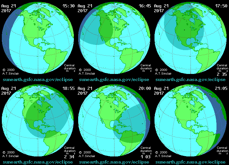
The eclipse calculator site also has a neat animation of the shadow of the moon moving over the earth's surface, although the one shown below from Wikipedia, is not bad. Note the tiny little black dot in the middle of the larger shadow.  That is the area of total eclipse.

by A.T. Sinclair - http://eclipse.gsfc.nasa.gov/, Public Domain, https://commons.wikimedia.org/w/index.php?curid=8973106

I find it easier to understand the 2D map showing totality after seeing this type of 3D animation.

Things to watch for in a total eclipse.  I was aware in general of what the eclipse will look like and also NOT to look at it directly with the naked eye.  We will probably not be trying to do any photography of the eclipse itself since it requires special filters and there is the risk of damaging the sensors in the camera.

However, this page indicated the following neat things to watch for near or during totality:


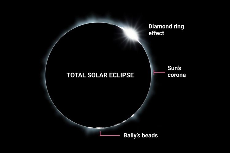
Illustration of totality of a Total Solar Eclipse
Phenomena only visible near the totality.
©bigstockphoto.com/JohanSwanepoel
Certain phenomena that can only be seen during a total solar eclipse:
  1. Shadow bands: About 1 minute before totality, moving wavy lines of alternating light and dark can be seen on the ground and along walls. These shadow bands are the result of Earth’s turbulent atmosphere refracting the last rays of sunlight.
  2. Diamond ring: Seen about 10 to 15 seconds before and after totality, the solar corona (the outer atmosphere of the sun) becomes visible; seen together with a single jewel of light from the sun, this creates a diamond ring effect.
  3. The Sun's corona: As the diamond ring fades, the Sun's corona becomes more prominent and is visible as a faint ring of rays surrounding the silhouetted Moon. The corona is the outermost layer of the Sun’s atmosphere, and it is around 200–300 times hotter than the Sun’s surface. The corona’s temperature can reach over 1 million °C (1.8 million °F).
  4. Baily's beads: About 5 seconds before totality, Baily's beads appear. They are little bead-like blobs of light at the edge of the Moon. They are created because gaps in the mountains and valleys on the Moon's surface allow sunlight to pass through in some places but not others.
  5. The Sun's chromosphere: A lower layer of the Sun’s atmosphere, the chromosphere, gives out a reddish glow which can only be seen for a few seconds after totality sets in.

Past eclipses.  The only eclipse (partial, not total) that I remember seeing was one in the early 80's.  According to the eclipse calculator, that was probably May 30, 1984. According to this site, it was a magnitude 0.83 in Lewisville.  I remember looking at it using the glassblower's didymium glasses (apparently not recommended, since not all such glasses are certified) on the front steps of the chem building in Denton.  The thing that was so unusual even without totality was the strange nature of the light.  That was my first realization that much of the light we routinely see that filters through trees is refocused images of the sun...i.e. think pinhole camera, but it is the tiny spaces among the leaves in the trees that are the "pinholes".  During the partial eclipse there were small little crescent images of the sun everywhere.  Very weird!

Future eclipses.  If disaster strikes, i.e. it is majorly overcast and we do not see the eclipse on August 21, we only need to wait another roughly seven years.  On April 8, 2024 there will be another solar eclipse visible in the U.S. and  Lewisville will be in the region of totality!  Mark your calendars now!