tale, n. A narrative of real or imaginary events; a story. fable, n. An entertaining and often oral account of a real or fictitious occurrence. Turkey Tales and Frog Fablesn. A narrative of travels and events, mostly real and sometimes entertaining, of the Turkey and the Frog.
It has been a long, drawn out planning process, but the landscaping makeover of the backyard and south side yard has finally begun.
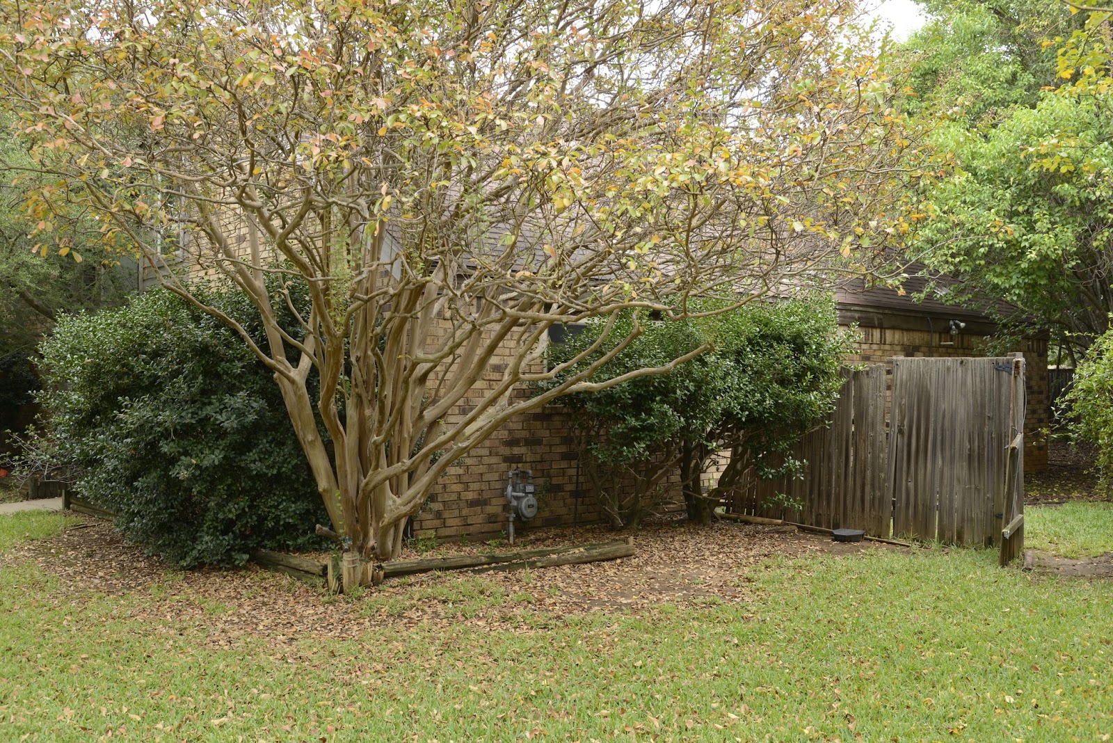
The yard needs help. We took the spa down several years ago and began thinking about eventual ways to upgrade the yard, which no longer could support grass due to the shade. The birds really love the overgrown bushes, but for us not so much. The bushes are taking over large expanses of the yard. It is not too bad when viewed from the yard side,
The patio as seen from the spa area. Note the partially buried concrete footers in the foreground leftover after removing the spa gazebo.
but from the patio and house, the Chinese holly seem to be taking over the world.
The Chinese holly are trying to take over the patio.
That is just the back yard. In the side yard the "dwarf" Burford hollies, despite frequent trimming, totally block Gwen's bedroom window.
These Burford hollies have had lots of trimming (note the open space underneath), but that just seems to invigorate their growth skyward. Believe it or not, there is a window in there somewhere.
That doesn't address the fact that the fence is in need of immediate attention.
The hollies and the wedged in 2x4's are holding up what is left of the fence.
So what do we want in a "new" yard? We want it to be bird friendly, low maintenance, and at least somewhat more open. We will likely keep the ligustrum, therefore it will still be shady. Flowers to attract butterflies and hummingbirds would be great, if such things grow in the shade. Finally, we also want to accommodate a vegetable garden in the side yard, if possible.
Starting in the spring we tried to hook up with several different landscaping designers with no luck. They wouldn't even return our calls. I think they thought this was too small a project. We finally found the current people, StoneCrete in Flower Mound and Argyle. We originally contacted them in August and have since had several meetings. The owner, who also did all of the design work, is more detail oriented than we are...yes, it is possible! That has made for a good match.
We all agreed on a final plan (at least for the back and side yard) at the end of October and we gave them the go ahead to start.
Part of the final (10-30-15) plan showing the backyard and side yard. The front yard is for sometime in the future, if at all.
Legend 1
Legend 2
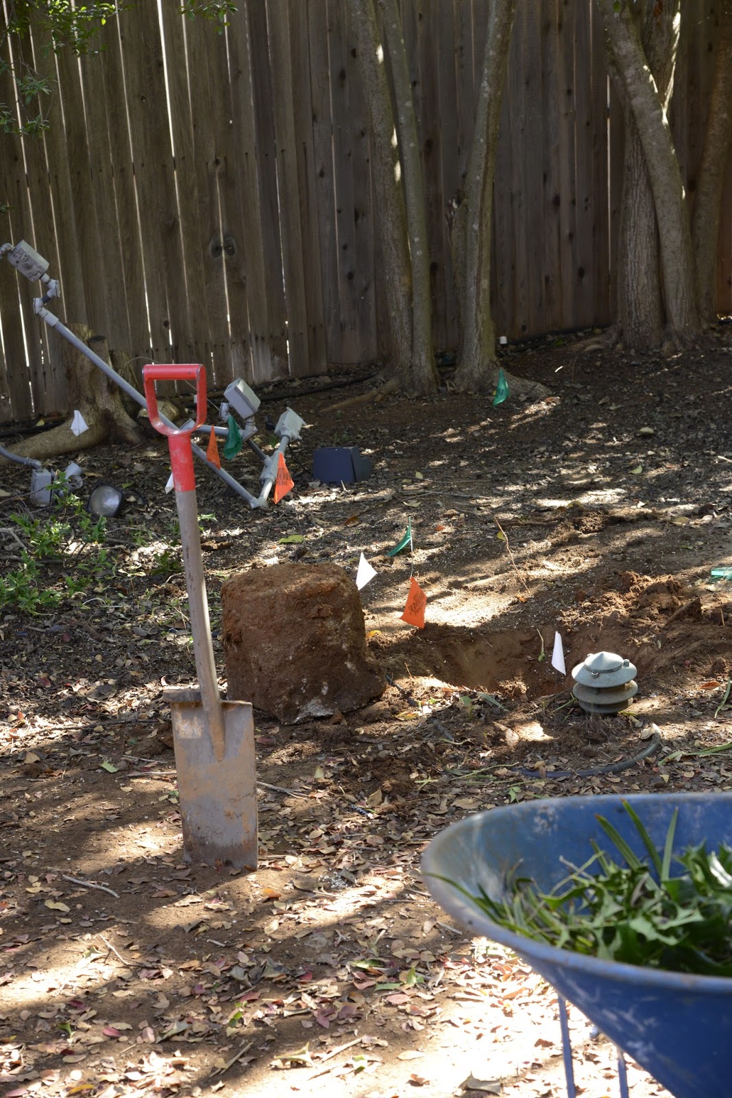
First up--locating buried wires and pipes. We anticipated that locating the various buried items in the yard could take up to a week. The locator company found the many buried Verizon lines (phone/internet cable) and the electric line. They also marked the sewer line in the front yard. However, they could not find the gas line since it did not have the "required" wire running on and along the pipe. (On November 17, additional locator personnel finally found the gas line and an unknown, at least to us, line from the neighbor's house across our front yard to our gas line.)
Orange lines are Verizon. Red flags mark the electric cable.
We also flagged some of the buried items in the backyard.
Green flags, nine concrete footers; blue flags, water hoses and air lines between spa pump and spa; white flags, sprinkler lines, orange flags, electrical cable. These are all abandoned, but may make working in the dirt interesting.
Work begins--11/13/15. A crew of five and their supervisor arrived on November 13 to trim the yaupon hollies in the front and on the north side and to begin the demo work in the back and on the south side.
The power saw on a long handle made yaupon trimming faster than when we do it ourselves.
They jumped right in and got to work.
The Chinese holly begins to disappear.
Despite cutting and mashing everything down, it took two very full loads of this large trailer to haul off everything they cut today.
One of the nine concrete footers for the spa deck. These were made by the Frog---made to last!!
Without the support holly, the fence was quickly history.
The plastic edging took a lot of effort to remove.
No turning back now. We were impressed by how much the crew got done before dark. However, the current look is that of a moonscape or, as pointed out by the Frog, no man's land between the trenches in WWI. Whatever the current look, it is clear there is no turning back now.
Most of the wild life and the cat are in shock, but the squirrel (see foreground) was still able to find the water bowl.
The entire day, at least in the backyard, in less than 3 minutes. Here is a time lapse of still images taken every 10 seconds from 10:34 am to 5:48 pm with my GoPro Hero 4 Silver and played back at 50% of the default rate.
It has been a very long time since I last posted here. We have been busy. Our time has been filled with mostly routine day to day activities such as lots of walking, but it has also included some not so routine activities such as replacing the house air conditioner...twice.
We are getting ready for our next big project...a total redo of Backyard World. Since we are farming that out to the professionals this time, hopefully it won't take a thousand weekends. In any case, I definitely want to capture that project on GoPro. Before I do that, I realized I needed to save and process the video that was on the GoPro memory card. Of course, since it had been so long, I had to relearn how to do everything again, saving and processing the video, working with the blog, etc. etc. Here goes what feels like starting all over again, so bear with me.
The First Family. Back in the early spring we had the excitement of a family of Carolina wrens in the bird house outside of our bathroom window. It was great fun to see them carry sticks into the house to make their nest, then ferry meal worms back and forth from the feeder in the backyard to the nest. We did not see the baby birds after they left the nest, but heard the entire family in the trees in the front yard. We also assumed they were among the wrens that occasionally visited the feeders in the backyard later in the summer.
We did not know whether any of these birds would return to the birdhouse, so we initially left it alone. However, after seeing no activity for several weeks, we opened it up and cleaned it out.
Wren nest inside the house after the birds had left.
The nest is small, but completely fills the house although stays several inches below the opening. As a point of reference for scale, the diameter of the round opening is 1.25 inches. It is big enough for the wrens but not big enough for the sparrows who desperately wanted to use one or both of the houses.
There were lots of leaves and other padding to go along with the interwoven sticks.
The nest was quite impressive. It took a lot of work to weave all of the sticks together. They had also used lots of soft material as padding. Wrens can often have multiple families per year, so we were hopeful either these wrens or some others would move in.
The Second Family. Although we never saw any more activity around that house, it wasn't too long before a pair of wrens began building a nest in the house above the patio at the back door. That was particularly exciting since that house had been up since last summer with no tenants. We don't know if it was the same or different birds. They seemed to go through the same struggles of learning how to get the long twigs into the small opening as the ones outside the bathroom had endured, but maybe that is always an issue.
With the bird feeders nearby, there was much more activity in the backyard compared to the side yard. Some of the other birds (particularly the titmouse) seemed to bother the wrens quite a bit. In particular, the wrens took exception when the titmouse landed on top of their house and bent over to look into the opening. Without a perch below the entrance hole, the titmouse could only peer over the edge from the roof In any case, with much yelling and screaming, he was quickly chased away by the wrens.
Our coming and going through the patio door was also somewhat of a distraction to the wrens, although they eventually seemed to get used to that if we stayed our distance. I also tried setting up the GoPro on the old video tripod.
With this camera setup I could remotely control it from inside with my iPad.
By controlling it remotely from inside, I thought the birds would be ok. I am not sure if it was the blinking red light (which I did turn off) or just having something new near the entrance to their house, but they were quick to check it out.
This wren was concerned (or at least curious) about the camera set up close to the front of his house which is out of the frame to the right. Notice also the blue jay in the background on the hanging feeder.
Since they were concerned we changed to making most of our observations from inside behind the patio door.
Even from inside, it was easy to see their furious activity going into and out of the bird house. The poor parents must have been worn out. They seemed to be continually busy bringing in food and
removing little white pouches that we eventually figured out were "disposal diapers". We had marveled at how clean the other nest had been when we cleaned out the house. Now we knew why.
Baby Wrens. Nearing the end of June, we could hear the chirping of the baby birds in the nest when the parents brought food. We assumed they would be leaving soon, so I had the GoPro ready at the back door (but inside!) on the tripod. It seemed unlikely we would be at home and watching when they left, but we wanted to be ready if we got lucky.
Well, we got lucky. It is not great cinematography and I missed a bit of the action at the very beginning, but hopefully the video captures some of the excitement of this momentous event...Moving Day for the Baby Wrens. I recommend you view the video on full computer screen since wrens are small. However, as you can see, baby wrens are not much smaller than adult wrens. Also make sure you have turned on the sound.
We cleaned out the house several weeks later. It was somewhat different than the nest in the other house. We don't know what they used, but there were copious amounts of some type of white fluffy material, perhaps the stuffing from a chair or some type of insulation. Whatever it was, it looked to be very nice, soft padding for the little ones.
Inside the bird house that had been over the patio (after the birds left). Note all of the soft padding.
Except for occasional visits to the feeders or except for visits to scratch around for bugs in the mulch along the fence, we did not see the wrens much for the remainder of the summer. Based on the success this year, we are hopeful we will have more birds using the houses next spring. If they do, we may feel confident enough to open up the bird house and take pictures of the nest while it is in use...something we did not do this year. Stay tuned.
On Tuesday...exactly two weeks after my original Fitbit died...I had a warranty replacement Charge HR Fitbit in my hands (or should I say on my arm?) and working. The time seemed much longer while I was waiting, but Fitbit actually handled this very swiftly. Although it took Fitbit technical support a week to respond to me initially, they immediately agreed with my list of troubleshooting efforts and offered to send a replacement if I showed proof of purchase. Through some miracle I found the receipt. Fitbit sent the replacement, USPS delivered it, and all is well again.
With or without the Fitbit, I really enjoy our walks. They continue to be better than one might imagine given the urban/suburban setting and the current less than ideal weather, i.e. heat (high today is expected to be 103 with a temperature humidity index quite a bit higher than that). The high quality walking is primarily due to the extensive paved trail system in Highland Village. As good as it is, the trail system will expand and improve considerably once Double Tree Ranch Park is finished later this summer or fall. With the current trails, we tend to rotate among three different loops we have cobbled together that range from about 3.8 to 6.5 miles in length.
No matter which trail, we almost always see something interesting. The spring wildflowers along City Trail are now long gone, but we see many birds. There are the large complement of normal suburban birds, but we even occasionally see roadrunners in the large open spaces. There are also numerous Mississippi kites, which were new to us. They have a profile reminiscent of a falcon as they slowly soar looking for insects. Although we have seen them routinely while walking this summer, they apparently will soon be departing for South America.
We occasionally see turtles. Squirrels are everywhere, especially on the bird feeders. We used to see multiple rabbits, but then stopped seeing them as often about the time we saw a coyote on two different days.
Unfortunately I seem to have developed a mild case of runner's knee. This is in spite of the fact that my knee has not been involved in any running activity for years. I am cutting back to the shorter walks for a few days and am now using a knee brace, both of which seem to be helping. Hopefully this is only a temporary setback and won't cause major interruptions to exploring the trails.
My FitBit Charge HR died yesterday. Well, maybe not actually died, but it seems to have advanced Alzheimer's disease. It can no longer communicate with other devices (so no longer knows the correct time and cannot upload data) and loses a full battery charge in less than two hours.
I had come to really love my FitBit. I got it for my birthday in February and have been using it ever since. I reported on it briefly in a previous post.
My FitBit Charge HR back in the days when it still worked.
I discovered the problem at lunch yesterday when I looked down at it, since I use it as a watch, and could get no display. I was of course immediately in DENIAL. The battery can't be dead already. What is wrong??!! The battery was totally dead even though I had recharged the battery less than two hours before.
Of course I recharged the battery, rebooted, removed and reloaded software, etc. etc. etc., but to no avail. Although I would have BARGAINED for a resolution, I was mostly just ANGRY at FitBit for creating a product that would not last more than a few months before dying.
Now I am just DEPRESSED, since using the FitBit had become such a center piece of my existence (sad but true). When originally setting up my FitBit account in February it asked for a weight goal. Weight loss was not the major reasoning for using it. What I really wanted to do was just be more active. However, I played along and chose a number. There was nothing very special about the weight goal that I chose other than it ended in zero and was so far out of reach for me to achieve that I wouldn't really worry about it. Although I had already lost a little weight at that time, it would require losing an additional 22 pounds. That was not going to happen so I wouldn't have to worry about it.
What do you know? Using the FitBit in conjunction with logging all of my food made it very easy to compare how many calories I had eaten at any particular time on any given day with the number of calories I had burned. To lose one pound per week all I had to do was burn 500 calories more per day than I consumed. I never dieted, just watched portion sizes, cut back/skipped dessert on those days I had not burned enough calories, or made an effort to do more exercise on other days. I was religious about logging all of the food. It also evolved into more and more walking. It was just a game and I was having fun. As of last week I hit the arbitrary weight goal, i.e. I had lost 22 pounds. WooHoo!
Having reached the first goal, I of course set a new goal. However, everything has changed again without the FitBit. We did our usual 6.5 mile walk this morning (yes, even though it is now unbearably hot and humid), but now I am flying blind. I did not realize how much I had come to depend on my FitBit. I can now only guess at how many calories I burned. I can keep track of how many calories I eat, but what is the point if I don't know how many calories are burned?
I have not yet ACCEPTED that FitBit is gone. I wrote to FitBit's technical support earlier this afternoon and outlined my problem. Now I wait. They indicated it might take 2-3 days for a response. If they cannot suggest a fix I am hoping they will replace it under warranty. We will see.
The sun is out and the flood waters at Lewisville Lake have begun to recede, but "begun" is the operative word. This is going to be a very slow process.
The lake set a new record high level of 536.95 feet above sea level at 1:00 am Sunday morning, May 31. This is the apparent downward corrected figure from the preliminary number of 537.02'...can they really measure the height of the water with that amount of accuracy?? The previous record was 536.73' in May 1990. The important thing is that it got up to (but not over) 537', which is the flow easement. At that height it is five feet over the spillway, which is at 532'. All of this is well above the "normal" or conservation level of 522'.
As of 1:30 this afternoon, the lake had dropped to 536.18'. Because of flooding of the Trinity River downstream, the Lewisville Lake flood gates are closed. However, lots of water is rushing uncontrollably over the spillway. That will continue until it drops to the level of the spillway, 532'. In the last few days we have seen flow rates in the river below the dam as high as 21,000 cubic feet per second. As the level of the water drops, the flow rate over the spillway has also dropped, now to about 15,000 cfs. The Army Corps of Engineers is not likely to increase the flow rate anytime soon, because the Trinity River is still above flood stage down stream, e.g. at Dallas.
Even though the problems have not been great here, many things have not returned to normal. All boat traffic is currently forbidden on Lewisville Lake. The DCTA A-train
is not operating along its entire line (Denton to Carrollton) due to water over the tracks in some locations. Highland Village Road is still closed near I-35E. Our
trash pick-up is running behind schedule because access to the dump is
flooded and the trash trucks are having to go to another dump which is further away. Of
course, all of the various parks and trails near the lake are closed.
These are VERY minor problems compared to the flooding of homes and
apartments elsewhere.
We walked to the lake Sunday morning to check it out. That required a somewhat circuitous route because Sellmeyer is closed for road construction. The S-curve is being removed. This is part of the construction of a new housing development called Wichita Estates, which will be east of Sellmeyer and south of Wichita Forest park, the dense green area in the Google earth shot below.
The approximate locations of the following pictures, all along Highland Village Road north of Wichita Forest, are shown on the Google earth shot above. When we were there on Sunday morning the lake was at approximately 537'.
1. The first shot is looking east along Highland Village Road from the corner of Highland Village Road and Sellmeyer Lane. There is nothing particularly extraordinary in this shot until you realize that the lake ahead on the left is actually the parking lot to the boat docks.
Looking east along Highland Village Road and the pedestrian/bike path from the corner of Highland Village Road and Sellmeyer Lane
It is not necessarily apparent in these shots, but the water was right up to the edge of Highland Village Road on both sides. I am not sure the sandbags would have helped much if the water would have risen further, but they do prevent water washing onto the road from waves/wakes.
Entrance to the parking lot of Lakeside Community Park. The paved trail that circles the park is in the background.
Entrance to Lakeside Community Park looking a bit more towards the east. The trail that circles the park is adjacent to the light pole.
3. This is the entrance to the boat docks. The green in the foreground around and beyond the fire hydrant is NOT dirt/grass, it is algae and scum floating on top of the water. The lake was several inches up on the bottom of the fire hydrant.
Entrance to the boat docks with water up to the edge of Highland Village Road
Entrance to the boat docks from street view on Google earth with the lake at a more normal level. Although not apparent in this shot, there is a significant drop in elevation from the road down to the parking lot.
4. Looking south along the eastern edge of Wichita Forest. The construction fence surrounds the park due to road construction. This muddy mess will eventually be a road that leads to a new housing development further south. The "puddle" across the center of the picture is the minor creek through the park which is now part of Lewisville Lake.
All of these pictures show Lewisville Lake at its new record level of approximately 537'. I hope we never see it at this level again.
Rain, rain, please go away. When we woke up this morning, the rain gauge indicated we had had 3 inches of rain overnight. That could not be good.
It was only after we turned on the tv that we discovered we had gotten off lightly. Many other areas in the metroplex had gotten over 6 inches of rain. The news reported that freeways were flooded and high water rescues were in progress. The new rainfall total for the month at DFW is now 16.07", an all time record for the month of May...or at least for the 117 years they have been keeping records.
What about problems in our immediate area? The exit ramp to Garden Ridge from southbound I-35E is closed due to high water and is expected to be closed for at least several days. Highland Village Road near the interstate is closed due to flooding. The exit ramp to FM 407 from southbound I-35E was closed for much of the day due to flooding.
Highland Village Road (5-29-15) looking east through the construction site towards the service drive and I-35E, courtesy of City of Highland Village
Those closings near the interstate will certainly add to the fun on I-35E this weekend, since the FM 407 bridge is scheduled to close permanently tonight. Access across the interstate will not be restored until summer of 2016.
But back to the water issues. Lewisville Lake is now (6:30 pm, 5-29-15) at 535.85 feet. That is 13.85 feet over the conservation level (522') and 3.85 feet over the spillway (532'). Perhaps most importantly, it is only about a foot below the flow easement of 537', which is where real property damage would likely begin to occur. It is above the flow easement where people can build permanent structures on their property. How much will be impacted? I don't know, but the county currently has an interesting map showing where the lake would be if it got to 538'.
With water at historical levels, we had to go check it out for ourselves. We first of all went to see the Lake Lewisville spillway, which is on the east end of the dam near The Colony. Unfortunately we could not get to a good location to see much. It was obvious from the cars pickup trucks parked along the road that some had decided to hike along the top of the dam past the "authorized persons only" sign to see the spillway up close. We decided against that, but did see that the water was almost up to the level of Business 121 where the spillway water runs into the Trinity River.
With little to see there, we revisited the sites we discussed in the previous post. The water was only about 1.5' higher this afternoon than on Tuesday, but oh what a difference!
1. Lake Park Road at Lake Park Golf Course.
Tuesday, May 26
Friday, May 29
Tuesday, May 26
Friday, May 29
2. Lake Park at the fee station. There did not seem to be as much difference here until we looked in detail at the level of the signs sticking out of the water.
Tuesday, May 26
Friday, May 29
Tuesday, May 26
Friday, May 29
We talked briefly to the park ranger, who was putting up more barriers. He told us that after the flood of 2007, which was less severe than this year, the park did not reopen until Labor Day. He thinks it will be at least Labor Day this year before the park can reopen.
3. First hole of Lake Park Disc Golf Course. The wire cage on the first hole is now just barely sticking above the water.
Tuesday, May 26
Friday, May 29
4. North Mill Street This was coned off. We could not even get close enough to see the water.
5. Copperas Branch Park East. The road that goes past the trail head was barricaded, but we parked and walked to the barricade. The new parking lot at the trail head where we had parked on Tuesday is now completely under water.
Friday, May 29
Will Lewisville Lake continue to rise? Will it get to 537'? Probably. Runoff
continues to go into the lake and more rain is predicted for tonight.
If that were not enough, Lake Ray Roberts, which is currently at
644.19', is expected to go over its spillway (645.5') for the first time
ever sometime before the end of the weekend. That means uncontrolled release of more water into Lewisville Lake.
In case inquiring minds want to know and since the Frog asked...I know we are well above 537', but how much further? The only topo map I have of our neighborhood puts us somewhere between 558' and 591'. GPS's are notoriously poor at determining elevation, but my gps fluctuates between 560' and 570' when lying here on the den floor. That would seem to put us at least 20' and probably more like 30' above the flow easement of the lake.
Update: Lewisville Lake continues to creep higher. As of the 8:30 pm report, it is now at 535.93'. It will be interesting to see what it does in the next few days. Elevation of Lewisville Lake is at this site. The summary of all of the lake levels is at this site.
It just keeps raining and raining and raining. It has rained 11.88" so far this month (19 out of the past 25 days) and 19.97" this spring (56 out of 86 days). This is only the 8th wettest spring (wettest on record was 29.01" in 1957), but already the 4th wettest May. The wettest May on record was 13.66" in 1982, our first May in Texas. That record certainly seems in jeopardy since rain is predicted every day for the remainder of the month. Stay tuned.
In the meantime we slosh through water, which is everywhere. We are fortunate that there have not been any catastrophic problems in the immediate area, but Lewisville Lake is definitely flooded. According to this site from the Army Corps of Engineers, Lewisville Lake was approximately 534 feet at noon today, which is 12 feet above the conservation level (522 ft) and 2 feet over the spillway (532 ft). These numbers are interesting, but we wanted to have some feel for what that level of flooding actually meant so we decided to check it out in person this morning. The approximate locations of the sites referred to in this blog are shown on the following map (blue push pins). (Here also is a link to an interactive Google map, but I did not know how to attach pins to that map.)
1. Lake Park Road at Lewisville Lake Golf Course. First up was a trip to the end of Lake Park Road, essentially the eastern extension of FM 407. The golf course is closed due to the water, although we saw multiple herons feeding in the ditch along the road and 5-6 Canadian geese camped out on the soccer field.
The flooding is clearly evident from the turn around at the end of the road.
View from the turn-around at the end of Lake Park Road (extension of FM 407) in front of Lake Park Golf Course, looking north towards the day use area. There is a road that runs perpendicular to this shot just beyond the large solitary tree to the left of center. The road is totally submerged, but can be seen in the street view on Google maps
View from the turn around at the end of Lake Park Road (extension of FM 407) in front of the Lake Park Golf Course, looking to the east. This is the practice range to the east of the golf course. The tees are in the foreground and the target flags are now out in the water.
It is a bit hard to put these pics into perspective until you compare them to a "before" shot. Check out the street view on Google maps. If you look carefully you can see the lake in the distance. Note the park road which is currently submerged in our pictures.
2. Lake Park We looped around to the entrance to Lake Park, which is in front of the disc golf course. It is now definitely a "Lake Park".
Next to the fee station at Lake Park
Looking along the road into Lake Park from the fee station
3. Lake Park Disc Golf Course All of the lower portions of the disc golf course near the lake are under water. One good example of that is the first hole. You tee off from an elevated tee, aiming for an elevated "green" in the distance. In between is a very deep depression. The "hole" is visible from the tee in the picture below. The bottom of the "hole" or wire cage is about 2.5 feet off the ground of the green, which is at least 4-5 feet above the lowest part of the first fairway, so some of the water in the foreground must be at least 7-8 feet deep! That's not such a big deal until you realize they had a professional disc golf tournament there on Friday, when the water was only about 2 feet lower. At least we think they had a tournament. We stumbled upon their displays when we were gawking at the water last week. Seven feet of water in the fairway takes golf's "casual water" to a whole new level.
First hole of disc golf course from the tee
4. North Mill Street. We next drove north on Mill Street. Mill Street ends when it turns left (west) and becomes Tennie Drive. You can see the the turn to Tennie Drive (guardrail and large arrow pointing left) in the distance in the following pictures.
Looking north along Mill Street.
5. Copperas Branch Park East. I had reported in an earlier blog about the new park, Copperas Branch Park East, that is not yet officially open but is being developed as part of the renovation of Interstate 35E. We decided to check that out on our way home. We had seen on previous occasions that access to the boat houses near the trail head was under water, but we were shocked upon our arrival to see that even a corner of the new parking lot is now under water.
The trail along the railroad that leads out to the park is also partly under water in at least one place, so we did not even try to make our way out to the park. I doubt much of it is above water anyway.
I don't know what to expect about the water level. The Corps is still dumping water into the Trinity upstream out of Lake Ray Roberts, but they are not letting as much water out of Lewisville Lake because of flooding downstream near Dallas.