Friday, October 20, 2017

LLELA Adventures

We have been having lots of fun observing nature while hiking the trails at our local nature preserve, Lewisville Lake Environmental Learning Area or LLELA.  The combination of hiking on easy but interesting trails and the large diversity of critters for the Frog to capture with his camera has made LLELA the perfect place for us.  However, it has turned into so much more than just a place to walk and shoot pictures.

LLELA's new Information Center

LLELA has not had any kind of permanent activity/nature center for the general public.  That changed recently with the opening of the new Information Center earlier this month.  This is a temporary, although perhaps multi-year, solution.  The current center is an "Information Center", not to be confused with a planned permanent nature center possibly built in cooperation with the National Audubon Society.   However, that may have to wait a few years for road construction and other improvements.

The new Information Center is in one of the portable buildings donated by LISD.  It is currently only open 9-4 on Saturdays and 1-4 on Sundays.  We went through the volunteer training two weekends ago and actually manned the center last Saturday, 9-1.

The Information Center is still a work in progress, but it was fun volunteering.  It does not look like much from the outside, especially since the permanent welcome sign is still on order, but it does have air conditioning and indoor plumbing.

The entrance to the Information Center with my homemade sign to let people know they could/should come in.

There are a few displays inside.


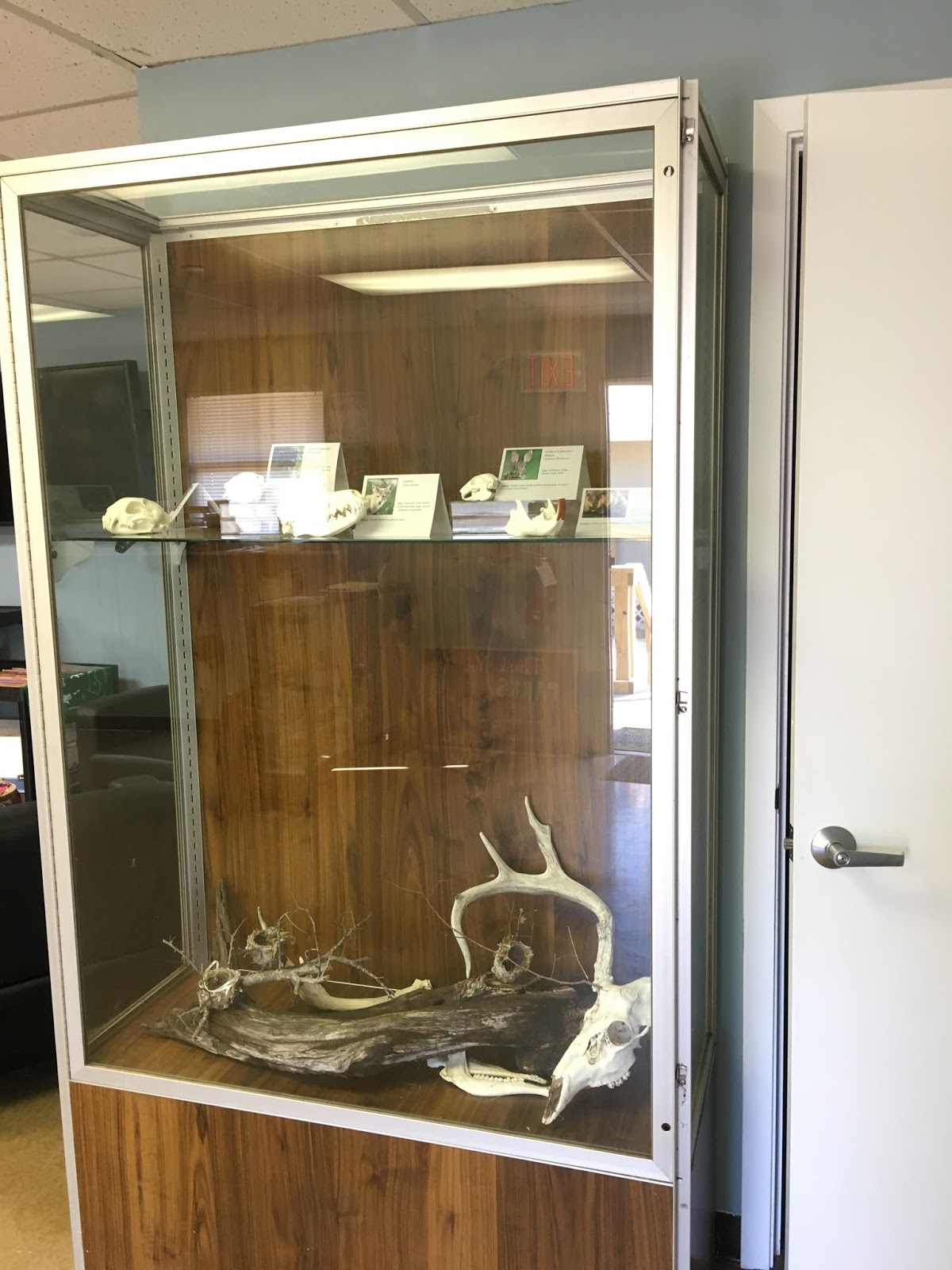
There are also some hands-on items to feel and touch:  beaver skeleton, alligator gar skeleton, bird's nest, etc. and a sandbox with molds to make animal tracks such as raccoon, deer, bobcat, and coyote. 


There is a very nice wall size map of all the trails at LLELA.  That came in very handy, since most of the folks that came by were interested in learning what trail they should take.  We are very happy to talk extensively about the trails since we walk the trails (weather permitting) at least once a week and often more.


However the best part of the Info Center by far, at least in my opinion, is the picture wall.  It is a collection of pictures of various animals, including insects, taken at LLELA.  These were the same pictures that were on display at the Lewisville Public Library during the month of August and include several of the Frog's pictures. 

Picture wall in the Information Center

Almost everyone that came in was surprised at the wide diversity of animal life that had been observed.  People seemed to especially enjoy the bald eagle, the bobcat, and some of the snakes.  However, the one that generated the most interest, hands down, was the alligator. 


Even More Excitement

As exciting as volunteering in the Info Center was, that was not even the high point of our LLELA experience that week.  On one of our walks we observed a damselfly whose identity has totally baffled the dragonfly/damselfly experts nationwide.  Yes, really!

Here is the story.

Having Fun with iNaturalist

When we walk at LLELA the Frog takes pictures of the living things we see.  Once we get home, I post the pictures as observations on iNaturalist.

I cannot overstate how much iNaturalist has helped us learn about the nature we are observing.  It is helpful in at least two ways.

First of all, iNaturalist has built in artificial intelligence that provides suggestions as to the identity of the animal or plant in the picture. This is a brand new feature in the past few months, although the development of the software and hardware took some time.  As a user I can say it is stunningly good.  With a few exceptions the suggestions are usually spot on.  It is also very user friendly.  Each of the suggestions comes back with links to pictures, the specie's Wikipedia page, maps of where it has been sighted, and a list with pictures of species with which it is most often confused.  Such immediate feedback and ease in doing more research makes learning about the things we see a lot of fun.

Once the observation with picture, location, and possible identity is posted, volunteers respond to help with the identity.  They can agree, disagree, or make alternative suggestions.  I have also sometimes asked them questions and they always seem willing to respond.  The volunteers doing the identifying can be anyone, but are often experts in the field.  What is stunning is the speed of the responses.  For birds and dragonflies the response can often be within minutes or less.  Admittedly we are helping ourselves by providing first class images, but we could not pay for the help we are receiving from these people.

New Critter at LLELA?

So what does this have to do with anything?  On October 6 we saw this bright blue damselfly while walking on the Blackjack Trail at LLELA.  You cannot tell from these zoomed in pictures but he is very little, probably two inches long max.

Mystery damselfly

Mystery damselfy

He is not that different from many of the other bright blue damselflies we have seen, but the markings on his thorax and abdomen didn't quite fit with anything that came up as suggestions on iNaturalist or was shown in any of the books I have on damselflies.  That is no biggie...I frequently struggle with damselfly identification.  I just listed it generically and posted it to iNaturalist. 


Here is our posting on iNaturalist which I made at 3:45 pm that day:  https://www.inaturalist.org/observations/8286492  By the time I checked back (after dinner?) I had a response from one of the major damselfly experts indicating this guy looked interesting but he could not identify it.  He was contacting some academic damselfly experts for help.  They looked at it over the next few days and they could not identify it either.   Apparently this little guy had the damselfly experts baffled.  Yes, really!!


Familiar Dancer??

Several of the experts thought it most resembled an Argia oculata or common name "Familiar Dancer".  They were also very excited and were urging people in the DFW area to go looking for it to confirm the ID.

OK, all of this did not mean much to me so I began to do some digging.  I initially had trouble finding out much about Argia oculata.  The known range for them is Mexico, Central Amreica, and northern South America.

Location of iNaturalist observations for Argia oculata.  Although not shown, they also exist in other locations such as Columbia

It was not in my books about Texas damselflies or U.S. damselflies since it is not known in the U.S.  I finally found a Wiki page in Spanish (Argia oculata on Wikipedia). (BTW, one of the translating programs translated what must have been the Spanish for dragonfly to "horse of the devil"!)  I finally found one page of info in English:  description and pictures of Argia oculata.

One of the comments under iNaturalist on our posting indicated that if it really was an Argia oculata, it would only be the second sighting in the U.S.  That would be cool.  What I did not know was that the first sighting had only occurred in September 2017 and was in far southern Arizona along the Mexican border.  (See Arizona dragonflies page for Familiar Dancer  and Troy Hibbit's page on Argia oculata).

Needle in a Haystack

It was clear no one was going to be comfortable making an ID from pictures for a critter that was so far from its normal range, especially since there was still ambiguity in the appearance.  It would be necessary to catch the little guy and send it to the lab for inspection under a microscope.


The Urban Wildlife Biologist in Dallas/Fort Worth with Texas Parks and Wildlife organized a get-together for Saturday morning, October 14, to try and find this little guy:  https://www.inaturalist.org/journal/sambiology/12081-lewisville-lake-on-saturday-10am-dragonfly-hunting    Unfortunately it was during our time volunteering in the Info Center so we could not tag along.  All the folks that did show up (about eleven total, I think) did stop by the Info Center to say hi before heading out.

Perhaps to no one's great surprise, they did not find the Mystery Damselfly but they all seemed to have fun.  At least we got to meet a whole host of nice people, many of whom we knew from online but had never met in person.

Was it a Familiar Dancer?  We may never know, but it was an interesting exercise that was only made possible because of the online community of people linked together through this remarkable program iNaturalist. Thank you software engineers! 

Tuesday, October 17, 2017

Eclipse Trip -- Great Smokey Mountains National Park

One of the last things on this epic adventure, but among the first we had put on our to do list when first making plans, was the Great Smokey Mountains National Park.  We stayed overnight in Cherokee, North Carolina, then drove to the Oconaluftee Visitor Center, arriving just as they opened.

Mountain Farm Museum

The Visitor Center was fine, but even better was the adjacent Mountain Farm Museum, a working farm made of various turn of the century farm buildings that had been moved to the sight.  Unfortunately most of them were closed, but we had the whole place to ourselves so had plenty of time to walk around and check things out.  Well, we were almost alone.  Being there early did give us the opportunity to see some local wildlife, a ground hog.

Some of the farm buildings with the ground hog in the foreground

I could not tell for sure what it was in the middle of the open area, but as I tried to get closer for a shot with my cell phone it looked like a very chubby rodent.


The ground hog starts retreating as I try to get closer for a pic with my iPhone, but he doesn't seem too concerned
   I am not sure what ground hogs eat, but he looked very well fed.


Ground hog munching on something

I presume farms in this area, i.e. out in the middle of nowhere, at the beginning of the 1900s had to be largely self-sufficient.  This farm had pigs, chickens, apple trees, a vegetable garden, and a corn field. It was interesting to see how they even stored ashes for making soap.


I don't know if the other members of our family who are currently making soap use the floating egg test for strength of the lye, but it would be interesting to see how that aligns with using pH paper.  :)
 
Ash hopper

Mingus Mill

Our next stop was only a half mile up the road, Mingus Mill.  Mingus Mill is an operating gristmill.  The mill was completed in 1886 and is still in its original location.  In place of a wooden water wheel this mill uses a small steel turbine, making it one of the most advanced mills in the Smokey Mountains when it was built.


We enjoyed talking to the person on site who was grinding corn while we watched.  We bought a bag of cornmeal, but found out later it was actually ground in a similar mill in Pigeon Forge.  Apparently it is impossible to maintain the cleanliness standards required by the Health Department at this mill and also be able to demonstrate how the mill works to visitors.


I was also surprised to see the "Keep Refrigerated" listed on the bottom of the package when I went to use it several weeks later.  I guess that is because there are no preservatives.  Despite it not being refrigerated, I used it to make cornbread per their suggested recipe.  The cornmeal is a bit coarser and more irregular,especially in color, than what I usually see from the store, but I would not define it as "coarse".  I don't know if their recipe is typical of what would have been done at the turn of the century.  At the very least I would have expected them to use an iron skillet rather than a pan.  In any case, I had never cooked anything with real buttermilk before.  Whether realistic or not, the final product was very good. 


Elk

We enjoyed learning about the mill, but still had miles to go so we set off up the Newfound Gap Road.  We had only gone a very short distance when we encountered cars parked haphazardly and people running everywhere.  There was a sizeable herd of elk in the open meadow beside the road.

By the time we got stopped, the large male had moved back into the woods.

Huge male elk

However, the females were still munching on grass out in the open.

I thought these were cows, but is the one on the left with horns a young male??

The cows did not look abnormally large, probably like large deer.  However, the male was enormous.  I am not sure whether it was him or another male close by, but we heard one of the males bugling.  That was cool!

All of them eventually wandered out of sight into the trees, so we climbed back into the car and headed onward.

Clingmans Dome

One of the iconic images associated with Great Smokey Mountains National Park is the observation tower on Clingmans Dome.  Clingmans Dome is the highest mountain in the park and the third highest peak east of the Mississippi at 6643 feet.  The guidebook indicated that the observation tower at the peak allows access above the trees for a panoramic view out to 100 miles on a clear day.  Note that the operative phrase is "on a clear day". More on that in a moment.


Is it something we were capable of doing?  Clingmans Dome is at the end of the seven mile long Clingmans Dome Road followed by a 0.5 mile hike up to the summit.  I couldn't find out much ahead of time about the hike other than it is very steep.  We weren't sure what to expect, but the trail itself.  was listed as paved so we thought we would drive out to the parking area and check it out.

The weather below had been fine.  However, at the parking lot and above we were in a cloud.  The weather was not bad, but it was very damp and there was not much of a view.  We had come this far so it seemed silly not to at least try to make the trek to the top.  Upward we went.

Looking down the trail.  It doesn't look nearly as steep here as it felt on the climb up

As we made our way up the paved trail (actually more like a road than a trail) our legs were not tired, but we still had to stop multiple times.  We are not used to being at this altitude.   Even at the start of the hike we were at 6325 feet according to my gps. 


We just kept going and finally made it to the top of the mountain and then to the top of the observation deck.  At 6699 feet it was an elevation gain of 364 feet in half a mile.

The view was not great, but it was still worth the effort to get there.

View from the observation deck


Looking down on the trees and the ramp leading up to the observation deck
The forest at the top with its cooler temperatures and high rainfall is a spruce-fir forest, similar to what is found in central Canada.  It was obvious there were many dead trees.  A European inset pest was accidentally introduced into the U.S. about 1900 and first discovered in Smokey Mountains National Park about 50 years ago.  It has already killed more than 70% of the mature Fraser firs in the park.  

But I don't want to dwell on the bad things about this hike because overall it was very good.  One of the highlights was the opportunity to hike on the Appalachian Trail...at least for about 6 feet or so. :) 

Yes, the sign does say Appalachian Trail.  I guess it would be a more convincing pic if I were wearing hiking boots rather than tennis shoes.
On our way back down we really enjoyed all of the flowers along the side of the trail. 


 Some of them were attracting huge numbers of bees.

I don't know what this plant is, but the bees sure loved it.


I should add that we were very lucky to make it to the top of Clingmans Dome when we did.  I only found out after we returned home that the trail and the observation tower were supposed to close on Wednesday, August 23, and remain closed for the remainder of 2017 for repairs.  We were there on Friday, August 25, in blissful ignorance.  Fortunately the closure was delayed at least for a couple of days and we made it to the top!


 Lunch at Chimneys Picnic Area

We had had a full morning of adventures and we were beginning to get hungry.  Fortunately I discovered early on there would be no place to buy lunch once we got into the park.  Therefore we scrounged around the night before in Cherokee for the makings of a picnic lunch.  I had also discovered early on that Chimneys Picnic Area was considered by many to be the best picnic area in the park.  It was right along our route, so it looked to be perfect. 

Again we lucked out.  The name comes from Chimney Tops, a mountain nearby and the location of one of the most popular hiking trails in the park, although steeper and more difficult than what we would want to tackle with our bad knees.  As it turns out, the summit of Chimney Tops was where the huge fire started in November, 2016, that eventually devastated parts of Gatlinburg and Pigeon Forge.  A newly renovated trail has only very recently (October, 2017) been reopened.  I have since read that part of the Chimneys Picnic Area was burned in the fire, but we did not see evidence of that when we were there.  In fact, the only areas of fire damage we saw were some of the hillsides while while driving along Newfound Gap Road after leaving the picnic area.

Map from the Visitors Center showing the area of the 2016 fire


I really enjoyed our stop for lunch.  It is obvious from the layout that the Chimneys Picnic Area used to be a campground.  There are 68 picnic sites, with parking immediately adjacent to each site.  The West Prong of the Little Pigeon River runs through the picnic area, with some sites immediately on the river.  (I did not know there was a Pigeon River!  Guess that is where the name "Pigeon Forge" comes from.  Duh!)

Sorry...caught you with your mouth full.
Although the sign on the middle of the picnic table warned about feeding the bears, we did not see any.

Sign on the picnic table at Chimneys Picnic Area.  Fed bears become nuisance bears which must often be euthanized.

However we did see a very aggressive crow and a cute little chipmunk, both of which came right up to the picnic site hoping for a handout.


One of  our lunch companions


The chipmunk was a bit more cautious than the crow, but was still moving in close for a possible handout.

It was so peaceful here it was easy to forget that Great Smokey Mountains is the most visited national park in the U.S., 11,312,786 people in 2016.  That is nearly twice the second place park, Grand Canyon, at 5,969,811.   I guess it helped that it was on a Friday and after many public schools had already started their fall term.  Yea!  One of the major perks of being retired!


Cades Cove Loop

It was only a little after noon and we had still not seen any bears, so we decided to do the loop through Cades Cove, an area known for plentiful wildlife.  Cades Cove is one of the most visited locations in Great Smokey Mountains National Park.  It is also very different from most of the other places we had seen in the park.  While previously we had been on the top of the mountains or in dense woods, Cades Cove is a 6800 acre wide open valley surrounded by high mountains.   


Before becoming a national park, essentially all of the land that is now the Great Smokey Mountains National Park was privately owned.  It was also the first national park with large areas that had previously been farm land.  Although the Park Service originally followed its policy of letting nature take its course, it soon became obvious that approach was not the best for agricultural areas such as Cades Cove.  The new approach was to manage the Cove as an "historic district".  There are now lots of historic houses, churches, and Cable Mill.  In fact, it has more historic buildings than any other area in the park.


The other major difference between Cades Cove and other portions of the park, at least during our visit, was the size of the crowds.  We were the only people present while visiting the farm museum and Mingus Mill earlier in the morning.  We shared the trip to the top of Clingman's Dome with only a moderate number of people and there were plenty of empty sites at the picnic area for lunch.  However, the one way eleven mile loop through the Cove was nearly bumper to bumper traffic. 

We stopped at the Orientation Shelter (small makeshift Visitors Center along the side of the road) at the entrance to Cades Cove and bought a tour booklet. 


I am very glad we did.  It gave us a description of each of the many sites as we made our way around the loop.  There actually were many potentially interesting stops along the way, but we must have been getting tired and beginning to think about making miles toward home.  Our only major stop was at the Visitors Center for a bathroom break. 

Heading for Home

We found out at the Visitors Center that we did not have to go all the way back to Newfound Gap Road to exit the park.  We took route 73, which took us to Townsend.  The roads kept changing numbers, but we continued through Walland and Maryville on our way to I-40.  That was definitely the right move, since we were then able to make it to just east of Nashville before stopping for the night.  We did not figure fighting rush hour traffic through Nashville on a Friday afternoon made sense.

Other than a new (to us) route around the south side of Nashville on Saturday morning, the remainder of the trip was the one we had made so many times before through Memphis, Tiny Pebble, and Texarkana.  We made it home without incident before dark Saturday night and were even able to avoid any significant rain from the outer bands of Hurricane Harvey that was beginning to pummel the Texas coast.

What a wonderful adventure this trip had been.  It was also so much fun to go back and relive many of the highlights while doing this online "scrapbook" of the trip. 

Sunday, October 15, 2017

Eclipse Trip -- Blue Ridge Parkway

Once we left the Stable Cafe at Biltmore, we were finally beginning the trip towards home.  However, we still had several things we wanted to see as part of what had become this epic adventure.  Most notable among the things we still wanted to see was Great Smokey Mountains National Park.

Since we were already on the North Carolina side, we thought driving through the park on Newfound Gap Road (US 441), the road that passes through the park, made sense.  The North Carolina terminus for Newfound Gap Road is at Cherokee, NC.  Yes, Cherokee had hotels and the hotels seemed cheaper than those on the Tennessee side, so that looked promising.

There are a couple of ways to get from Asheville to Cherokee.  We decided to take the slower but hopefully more picturesque route, the Blue Ridge Parkway.  Not being familiar with North Carolina, the Blue Ridge Parkway at first seems somewhat obscure.  However, it isn't totally unknown.  For example, it is the subject of the back of the 2015 America the Beautiful North Carolina quarters.

Blue Ridge Parkway featured in the 2015 America the Beautiful Quarters series

The Blue Ridge Parkway is a linear park that runs mostly along the ridgeline of the Blue Ridge Mountains for 469 miles through Virginia and North Carolina.  Administered by the National Park Service, there are no services (or at least almost none...more about that below), no billboards, no commercial traffic, slow speed limits (45 mph in most areas, slower in congested areas), and in most places no passing.  We did not know that much about the Blue Ridge Parkway but figured it would be somewhat similar, at least in concept, to the other linear park we had driven several years ago, the Natchez Trace.


GPS track (in red) along Blue Ridge Parkway from the Blue Ridge Parkway Visitor Center (milepost 384) on the right to Cherokee, NC  (mile post 469) to the left.


In retrospect, I did not do enough research on the things to see and do along this stretch of the Parkway.  It was still very worthwhile and a good way to make the trip given the relatively short distance (~85 miles) and the time of year.  It would have been an awfully slow trip if we had had to go a lot further or if we had been there during a busier time of year such as peak fall leaf season.  As I have since learned, it would have not been an option at all during much of the winter, since it closes due to snow on the road and especially due to ice in or near the many tunnels we passed through.

We started by making our way to the new  Blue Ridge Parkway Visitor Center which is just east of Biltmore at milepost 384.  Getting there was somewhat of an adventure in itself since we did not seem to have a good map, but we finally found our way onto the Parkway and finally found the Visitor Center.

We were successful in our main mission, i.e. getting a map of the Parkway.  What we did not know until later was that the Visitor Center has a movie about the making of the Parkway.  We would have definitely stuck around for that if we would have known.

Mt. Pisgah and Pisgah National Forest

With map in hand we were off.  The first part of our journey took us through what is now Pisgah National Forest.  This was originally part of the Biltmore Estate, but was sold to the federal government in 1914.  We passed by a major campground at Mt. Pisgah, but did not stop.  I did not know until later that this is also the home of the Pisgah Inn, a motel and a restaurant with panoramic views over the mountains.  I did not know until later that there were any such commercial locations along the Parkway.  Pisgah Inn would likely be an interesting place to stay or at least a gorgeous place to eat if we are ever through there again.

Overlooks

There were many many pullouts to take in the views.   As high as we were, we could sometimes look down on the adjacent mountains.

Funnel Top Mountain overlook at milepost 409.3

The views were spectacular.

View from Funnel Top overlook
Lots of the mountains in the landscape looked pretty much the same.   However Looking Glass Rock is distinct. It is one of the largest masses of granite in the eastern U.S., formed under ground from molten rock that hardened and then was subsequently exposed by erosion.  The exposed surface reflects the sunlight when wet, hence the name.

Looking Glass Rock overlook, milepost 417

Richland Balsam Trail

The highest point on the Blue Ridge Parkway is at 6,047 feet.  It is adjacent to Richland Balsam Peak, which tops out at 6410 feet.  "Balsam" refers to the Fraser fir and red spruce which are prevalent.  They are supposedly what produce the scent which permeates the air on the mountain.

My very inadequate map indicated there was a self-guiding trail through the forest to the summit from the Haywood-Jackson overlook at milepost 431.  Even though we knew nothing about the length of the trail, we decided at the last moment to see if we could make it to the top.  It did not look too bad.  The trail was paved (asphalt) and there was even a box at the trailhead for printed guides.

Sometimes appearances are deceptive.  The box for guides was empty so we still had no idea how long the trail was.  The paving extended for only 300 feet or so.   The further we went, the trail became rougher, steeper, and narrower, with lots of slippery, moss covered roots and rocks.  The trail was also totally enclosed under a canopy of trees with no views. 


Sine we had no idea how far it was to the summit and the footing was getting more precarious, we finally decided to turn around.  That turned out to be the wise choice, at least for us on that day without hiking boots.  It now looks like we probably made it about half way to the top, but would have encountered steeper conditions further on.  There probably would not have been any views from the top anyway.  It was still interesting to do the short hike in the dense, enclosed woods...typical for the Appalachians but so different from our usual hikes in the west.

Flutterbys

As great as the views were at the various overlooks, they were not the only things of interest.  There were butterflies virtually everywhere.  There were many Tiger swallowtails, which were easy to see as they floated over the edge of the overlooks.

Eastern Tiger Swallowtail
 

I was particularly stunned by the huge number of dark butterflies.  It is hard to identify butterflies at 45 mph so I do not know if they were all the same, but at least some of the ones we saw up close were pipevine swallowtails. 

One of the many pipevine swallowtail butterflies we saw along the Blue Ridge Parkway

Cherokee

We continued along the Parkway and finally made it to the town of Cherokee.  Although the area around Cherokee is sometimes erroneously referred to as an Indian reservation, it is more properly the Qualla Boundary, a land trust for the federally recognized Eastern Band of Cherokee Indians.  As a trust the land is technically not a "reservation" since the land was not "reserved" by the federal government.  It was purchased by the tribe in the 1870s and subsequently placed under federal protection.  Individuals can buy, own, and sell the land, provided they are enrolled members of the Tribe of the Eastern Band of the Cherokee Indians.  Members of the Eastern Band are descendants of those individuals who remained in the eastern U.S. after the Indian Removal Act moved 15,000 Cherokee to the west in the 1800s.

Cherokee was pretty quiet when we were there.  It looked like the tourist season was already over.  There were the obvious cheap touristy type things in town as well as a large Harrah's casino.  Cherokee is also known for some well done museums, including Museum of the Cherokee Indian.  However, we arrived too late to see any of those.  Most of our time, other than getting something to eat, was looking for the grocery store which had apparently moved since the database in my gps had been updated.  We needed groceries so we could pack a lunch for tomorrow's adventure to the National Park.

Monday, October 9, 2017

Eclipse Trip -- Biltmore Gardens and Stable

As you could probably tell from my previous post, I really enjoyed the tour of Biltmore House.  That is especially noteworthy, since I had not had high expectations for our visit.  I thought it would be just another tour of an historical house.  It was so much more.

BTW...By chance, I ran across a review in the weekend section of the Wall Street Journal of a book by Denise Kiernan entitled The Last Castle: The Epic Story of Love, Loss, and American Royalty in the Nation’s Largest Home.  Since I had enjoyed a previous book by this author, I decided to take a chance and downloaded it.  That is my excuse for having not gotten the next installment of this blog finished sooner.  Once I started, I could not put the book down.  I probably would not have enjoyed it nearly as much if we had not just visited Biltmore, but now I realize we missed seeing so much in and around Asheville, especially lots of architecturally significant buildings.  But I digress.
 

One of the things special about the Biltmore estate is that it is not just the house but also the huge grounds that were designed by  Frederick Law Olmsted, the father of American landscape architecture.  The current estate is "only" about 7000 acres or 11 square miles, a small fraction of its original size (195 sq miles or 125,000 acres).

Even at only 7000 acres it is still huge and we only saw a small portion of it.   


Map of Biltmore Estate.  Entrance is lower right.  Biltmore House and Gardens are in the center near the bottom.  Antler Hill is at the upper right.

Antler Hill Village and Winery

Other than driving through on the eight mile drive out of the estate, we did not visit Antler Hill Village.  It did not open to the public until 2010.  It is the site of two hotels, the Winery and a working farm with up close and personal experiences with the animals.

Of particular note is the Biltmore Winery which is on the site of what used to be the successful Biltmore Dairy.  It, at least according to their brochures, is the most visited winery in the U.S.  It was started in the 1970s and 80s, so it is not part of what was on the estate when George and Edith Vanderbilt lived there.  However, it is now part of what makes Biltmore a self-sustaining working estate, which was very much George Vanderbilt's goal for the place.  In any case, it is definitely on my must see list if we ever return.

Biltmore Gardens

Most of our time outside the house was spent in what is collectively called Biltmore Gardens.  These are a collection of different types of gardens within walking distance of the house.  These were originally intended as recreation and diversion for the Vanderbilts and their guests.  Although spread over two days, we explored nearly all of these gardens.


Italian Garden

Immediately after taking the house tour on Wednesday afternoon, we wandered outside and explored the Italian Garden.  The major feature of this sunken area paralleling the main esplanade in front of the house is a set of three formal water gardens.


There were interesting and (at least to us) unusual plants.


There were numerous flowers, fish and even dragonflies.


But it was hot in the sun and we were already tired from a long day, so we decided to come back in the morning for the remainder of the gardens.

Library and South Terrace

The following morning was a much more pleasant time to be outside.  The starting point for exploring the gardens is logically the Library Terrace and the South Terrace.  However, the South Terrace was filled with a stage and chairs for the REO Speedwagon concert later that evening.


However, from the Library Terrace we could still see the beautiful views of the Blue Ridge Mountains.  It is easy to see how the mountains got their name!


Shrub Garden, Spring Garden, and Azalea Garden

Descending down the hill into the gardens we quickly became engulfed in another world.  Close to the house it was still relatively formal.

Walkway below the South Terrace near the beginning of the Shrub Garden


Fountain in the wall below the South Terrace

However, the gardens become increasingly more natural further from the house.

We only saw part of the very large Shrub Garden, which was designed with more than 500 varieties of ornamental shrubs and trees.  This included both native plants and plants from around the world.  The area was laid out to create a quiet retreat through which to walk on the wandering paths.

Red Cutleaf Japanese Maple


We did not know what this tree was with the strange "fruit", but a search online suggests it might be a Himalayan flowering dogwood.  If so, each red fruit started out as the center of a blossom.  It must be spectacular in spring!

The largest of the gardens is the 15 acre Azalea Garden.  According to their literature, there are more than 1000 azaleas growing among magnolias, dogwoods, and numerous conifers. This must be spectacular in the spring when they are in bloom.  Even in late summer it was still a wonderful wandering walk through an area planted to feel like a native mountain woodland.   We saw some folks taking their morning jog and thought it would definitely be worth the price of an annual pass just to walk the gardens in the various seasons if you lived nearby.


Bass Pond and Boat House

Even further down the trails we finally came to the Bass Pond. 

Bridge near the Boat House on the Bass Pond


Boat House on the Bass Pond


Looking across the Bass Pond to the bridge at the far end

I don't know whether there were bass in the pond, but there were lots of butterflies and dragonflies flying everywhere.

A dragonfly photo bombs this picture of a Tiger Swallowtail butterfly feeding on a flowering plant at the edge of the pond
Although the entire area leading down to the pond was made to feel natural, we did not see any larger animals.  In fact, I did not think to look for any since even the nature areas were well maintained, trimmed and mulched.  It seemed more like a maintained park.  However, a Google search of "bears at Biltmore" produces multiple hits.  Biltmore Forest, the upscale residential neighborhood just over the hill from the Biltmore Gardens, had a significant black bear problem in 2016.  The bears apparently live on the Biltmore Estate, but are attracted to residential yards by bird feeders.  And we think we have problems with our bird feeders attracting squirrels!!?

Walled Garden and Rose Garden

Closer to the house is a large formal area known as the Walled Garden.  This was a huge area of plantings laid out in geometrical design.  The plantings change with the seasons, but the many bees and butterflies were certainly enjoying what was there now.

Looking down on the Walled Garden from the Spring Garden.  This is only half of the garden, with a mirror image on the other side of the 236 foot long arbor in the center of the pic.  Note also the stone wall in the foreground, hence the name "Walled Garden".


Bee on flowers in the Walled Garden


Butterfly in the Walled Garden
 
Flowers in the Walled Garden
On the lower level of the Walled Garden was the Rose Garden.  As with everything else at Biltmore, it was huge.  It contains approximately 2300 roses of 250 varieties. 

Part of the Rose Garden.  Note Biltmore House in the background on the right.

Conservatory


At the extreme lower end of the Walled Garden was one of our favorite sites at Biltmore, the glass-roofed Conservatory.

Part of the Walled Garden with the Conservatory in the background


The central room of the Conservatory is the "Palm House", with palms, ferns, and other foliage plants.


Big ferns in the Conservatory.  Note Turkey to the left for scale


None of the plants were labelled, but these certainly looked like bananas to us


Additional rooms include a cool house and a hot house.


But our fave was, the orchid house.

Yes, that tall plant really is an orchid!!


Close-up of the orchids on the previous plant in the previous pic


We spent a short time talking to one of the gardeners who was watering the plants.  She said they had about 40 full time gardening staff on site.  Many were like her that had a degree and extensive experience.

We were having fun, but we had miles to go and many more things to see.  However, there was one more location at Biltmore we were going to check out...the stables.

Stables

On the north end of the house is a separate building that from the outside looks the same as the house.  This is what once was the stables.  When the Vanderbilts were living at Biltmore, there were as many as 25 riding and driving horses and 20 carriages sheltered here.

It looked to us that these horses probably lived better than many of the people in the surrounding area.  The stable had electricity, plumbing, glazed-brick walls, and brass fixtures and hardware.  Of course there needed to be lots of storage areas, plus living quarters for single male servants, including grooms, harness men, exercisers, coachmen, etc.

Today the stables have been converted into a series of specialty shops.  For example, the largest shop is the former carriage house.  Most of the items were pretty pricey (I know, what a shock!), but we did get a Christmas tree ornament to commemorate out visit.

The courtyard between the house and stables is now outdoor seating with some small food concessions around the outside.


The old horse stable is now the Stable Cafe, with the original box stalls converted into booths.  This sounded quite interesting and fun when reading about this, so we planned our morning walk in the gardens to be back at the cafe by lunch time.


With great food and friendly service, this was a pleasant way to end our visit at Biltmore.