We usually do lots of preparation (many would say over preparation) for our travels. This time, due to unpredictable weather and unpredictable traffic, we did not know if it would be practical to take this alternate route or stop to see any sights even if we did. Therefore we did very little pre-planning. We saw some interesting new locations and got an overview of a new area, but in retrospect missed seeing quite a few interesting things.
One of the few decisions we did make ahead of time was to go south along the eastern shore of the Salton Sea in hopes of stopping at the Salton Sea State Recreation Area even though it looked to be the slower route on the map. We knew almost nothing about the Salton Sea other than it was a major stopover for migratory birds.
 |
| Area map from the Sonny Bono Salton Sea National Wildlife Refuge brochure |
We left early Sunday morning, December 28, which turned out to be a wise choice. Traffic was exceptionally light for most of the trip along the northern edge of the LA basin. We stopped in Indio for lunch one exit before the turn off to the Salton Sea. That turned out to be good since it is not obvious we would have had many (any?) choices once we turned off the interstate.
Traffic had been manageable before turning off the interstate. Now there was essentially no traffic as we skirted around Coachella and Thermal. Highway 86 was a very good, divided highway, but was nearly deserted. It also had the strangest left turn lanes we had ever encountered. The landscape was very dry and dusty, although there were occasional palm tree plantations. We left 86 and turned east to proceed south on 111.
Salton Sea State Recreation Area
First stop was the Salton Sea State Recreation Area. We did not know until later that the visitor center is only open on Friday, Saturday, and Sunday, so we were lucky to pass through on a Sunday. At the visitor center we watched the short film that presented a history of the Salton Sea, then headed out to check out the sights.
 |
| Frog in front of the visitor center |
There was a large parking lot with a few RV hookup spots along the side. There was also a small marina behind the visitor center and a location to rent boats and kayaks. However, the big draw here was the Salton Sea. A few folks were fishing, but most people were watching the birds.
 |
| On the beach near the visitor center at Salton Sea |
The park info claims there are more than 400 species of migrating birds that spend time here between October and May. I presume that includes some of the small birds I could hear, but not see, in the palm trees near the visitor center.
We did see a variety of birds on the water. The most abundant of those were the white pelicans. We had certainly seen pelicans before, but those had been brown pelicans, not white.
 |
| white pelican |
 |
| More pelicans on the Salton Sea |
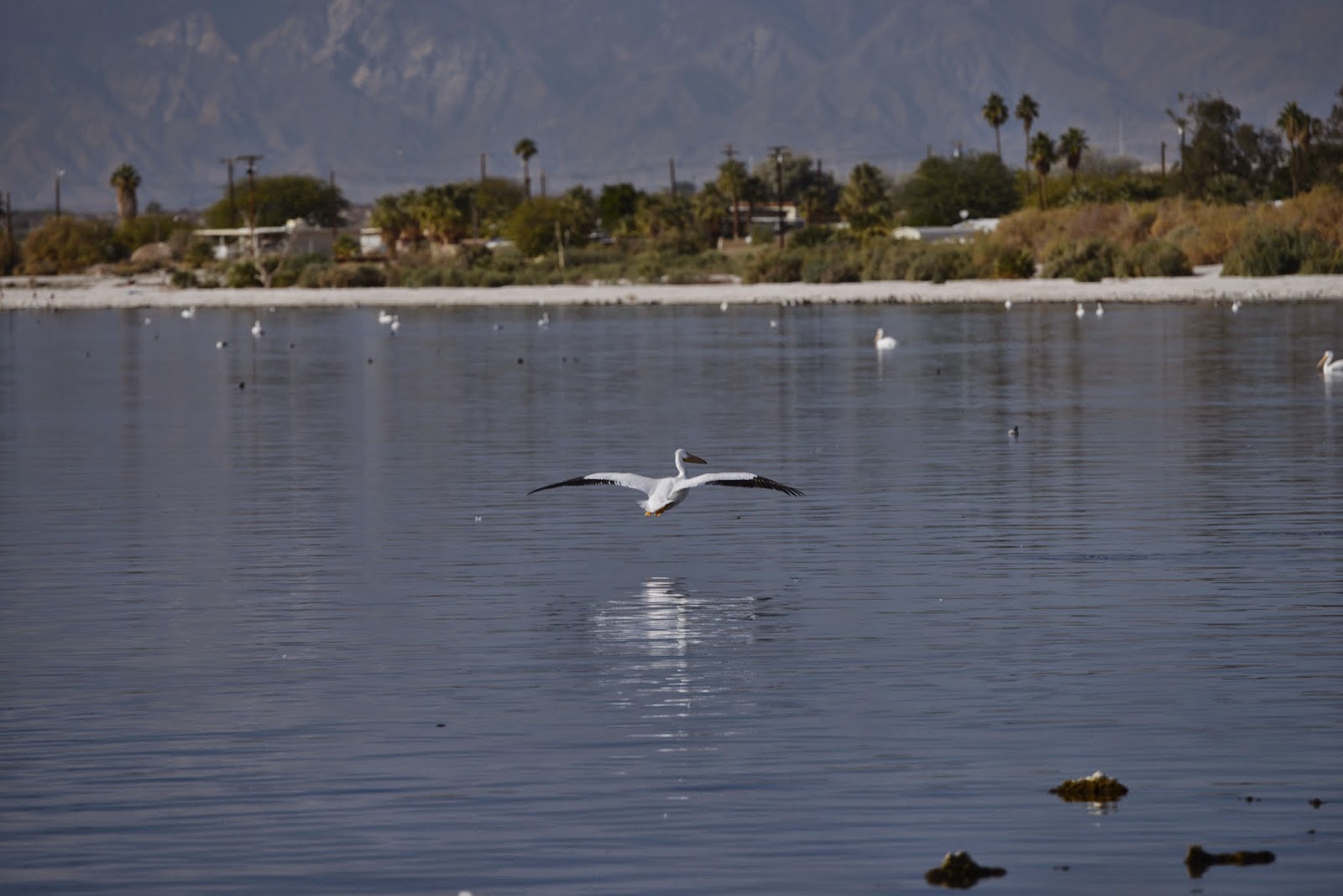 |
| white pelican in flight |
 |
| white pelicans and a brown pelican |
 |
| Looking back across the beach towards the parking lot from the shoreline |
Formation of the Salton Sea
The area within the Imperial and Coachella Valleys known as the Salton Sink has been flooded many times through both geologic and historical times. Some of these seas were much larger and deeper than today's version.
The current sea was somewhat of an accident. In 1905 irrigation canals fed from the Colorado River flooded, creating the Salton Sea.
 |
| Map from the Salton Sea State Recreation Area brochure |
Here is the description from Wikipedia:
In 1900, the California Development Company began construction of irrigation canals to divert water from the Colorado River into the Salton Sink, a dry lake bed. After construction of these irrigation canals, the Salton Sink became fertile for a time, allowing farmers to plant crops.
Within two years, the Imperial Canal became filled with silt from the Colorado River. Engineers tried to alleviate the blockages to no avail. In 1905, heavy rainfall and snowmelt caused the Colorado River to swell, overrunning a set of headgates for the Alamo Canal. The resulting flood poured down the canal, breached an Imperial Valley dike, and ran down two former dry arroyos: the New River in the west, and the Alamo River in the east, each about 60 mi (97 km) long. Over a period of about two years, these two newly created rivers sporadically carried the entire volume of the Colorado River into the Salton Sink.
The Southern Pacific Railroad attempted to stop the flooding by dumping earth into the canal's headgates area, but the effort was not fast enough, and the river eroded deeper and deeper into the dry desert sand of the Imperial Valley. A large waterfall formed as a result and began cutting rapidly upstream along the path of the Alamo Canal that now was occupied by the Colorado. This waterfall was initially 15 ft (4.6 m) high, but grew to a height of 80 ft (24 m) before the flow through the breach was finally stopped. Originally, it was feared that the waterfall would recede upstream to the true main path of the Colorado, attaining a height of up to 100 to 300 ft (30 to 91 m), at which point it would be practically impossible to fix the problem.
As the basin filled, the town of Salton, a Southern Pacific Railroad siding, and Torres-Martinez Native American land were submerged. The sudden influx of water and the lack of any drainage from the basin resulted in the formation of the Salton Sea
The Salton Sea is a very interesting place. It is actually much larger than it seemed on first observation. It is currently about 35 miles long and 15 miles wide. It is quite beautiful, a calm lake (or as the locals like to point out repeatedly, actually a sea) surrounded by a white beach and mountains in the background. It is no wonder that in its heyday in the 1950's it was a very popular resort spot and celebrity hangout, with more tourists annually than Yosemite National Park.
However, there are some issues
Salinity. The Salton Sea is a landlocked extension of the Gulf of California. There is some water flow into the sea, but there is no outflow. Primary loss of water is through evaporation. The water is therefore becoming increasingly salty. The lake's salinity is about 54 g/l, which is greater than that of the Pacific Ocean (35 g/l) but less than that of the Great Salt Lake (which ranges from 50 to 270 g/l). The concentration has been increasing by about 1% per year.
The increasing salinity over the years has resulted in the death of most original species of fish. Essentially the only fish surviving are tilapia. Although they exist in large numbers, there are periodic fish kills due to algae blooms. The remains of dead fish, partly preserved by the high salinity, are everywhere along the shore. The smell was not bad while we were there, but it is supposedly quite bad during the warmer months.
Heat. Speaking of "warm", the Salton Sea is very low in elevation, officially 228 feet below sea level! It therefore is VERY hot in the summer. The average temperature in June is 103°F, with a record high temp. of 121°F, and in July the average is 107°F and a record high of 122°F. Only Death Valley is hotter, with the highest official temperature ever recorded on earth of 134°F.
 |
| Yep, that is -228 feet. Only place in the U.S. that is lower is Death Valley at -282 feet. |
Humidity. But it is a dry heat, you say. Wrong! Due to the Salton Sea, the humidity is actually quite high, often greater than 90%!
 |
| From the Salton Sea Walk website: http://www.saltonseawalk.com/ |
With real high temperatures averaging 103-107°F, but possibly closer to 120°F, and humidity levels greater than 90%, the heat index is much higher than at very dry Death Valley. After trying to look up the heat index values for such a combination of high heat and high humidity on the Wikipedia heat index page (see chart below), I think the values for these combinations of heat and humidity at Salton Sea can be officially considered "off the charts". I did not use the NOAA supplied equations to extend the chart, but some of those values are available here. They are in excess of 150°F.
| temperature (°F) | |||||||||||||||||
| 80 | 82 | 84 | 86 | 88 | 90 | 92 | 94 | 96 | 98 | 100 | 102 | 104 | 106 | 108 | 110 | ||
|---|---|---|---|---|---|---|---|---|---|---|---|---|---|---|---|---|---|
| Relative Humidity (%) | |||||||||||||||||
| 40 | 80 | 81 | 83 | 85 | 88 | 91 | 94 | 97 | 101 | 105 | 109 | 114 | 119 | 124 | 130 | 136 | |
| 45 | 80 | 82 | 84 | 87 | 89 | 93 | 96 | 100 | 104 | 109 | 114 | 119 | 124 | 130 | 137 | ||
| 50 | 81 | 83 | 85 | 88 | 91 | 95 | 99 | 103 | 108 | 113 | 118 | 124 | 131 | 137 | |||
| 55 | 81 | 84 | 86 | 89 | 93 | 97 | 101 | 106 | 112 | 117 | 124 | 130 | 137 | ||||
| 60 | 82 | 84 | 88 | 91 | 95 | 100 | 105 | 110 | 116 | 123 | 129 | 137 | |||||
| 65 | 82 | 85 | 89 | 93 | 98 | 103 | 108 | 114 | 121 | 128 | 136 | ||||||
| 70 | 83 | 86 | 90 | 95 | 100 | 105 | 112 | 119 | 126 | 134 | |||||||
| 75 | 84 | 88 | 92 | 97 | 103 | 109 | 116 | 124 | 132 | ||||||||
| 80 | 84 | 89 | 94 | 100 | 106 | 113 | 121 | 129 | |||||||||
| 85 | 85 | 90 | 96 | 102 | 110 | 117 | 126 | 135 | |||||||||
| 90 | 86 | 91 | 98 | 105 | 113 | 122 | 131 | ?? | ?? | ?? | |||||||
| 95 | 86 | 93 | 100 | 108 | 117 | 127 | ?? | ?? | |||||||||
| 100 | 87 | 95 | 103 | 112 | 121 | 132 | |||||||||||
Caution
Extreme Caution
Danger
Extreme Danger
And there is more. It is not just the salinity, heat, humidity, and decaying fish. The white beach is not what it appears. It is not sand, but barnacle shells and fish bones. The barnacles were apparently introduced by military sea planes using the Salton Sea for exercises during World War II. With no natural predators, they have flourished. It was not a problem for us with shoes, but they are sharp. I could pick them up in my hands without an issue, but they are not appropriate for bare feet or even flip-flops. While we were there the volunteer behind the desk was warning a visitor not to take his dog on the beach to prevent him from cutting his paws.
And it is only going to get worse. According to one site, the Salton Sea loses about 66 inches per year due to evaporation. It only gets about 3 inches of rain. I don't know how much water has been flowing in, but not enough to maintain the size of the sea. It has shrunk considerably over the last several decades. Current changes in water appropriation will further decrease the inflow. I don't know by how much or at what rate, but that suggests the Salton Sea will get significantly smaller and significantly more saline in the foreseeable future.
It sounds like this is a horrible place. That is not true. It was beautiful while we were there. I would have loved to have spent more time exploring and watching the birds. I am glad we saw it before the various problems got any worse and hope we will be able to visit again in the future. However, I don't think I would care to be there in the summer.
Salton Sea Walk: 6 Days - 116 Miles - 120°F - June 2015
Although I don't plan to be there in the summer, I will be following an event this June. In researching the Salton Sea I stumbled across the website, Salton Sea Walk. This is the website created by Randy Brown, who is planning to walk around the shoreline of the Salton Sea this coming June. If successful, he will be the first person to do so. (This will be harder than the walk around the Salton Sea done using paved roads by Dinesh Desai in 2005.)
Although I first thought it sounded crazy, Randy is carefully planning everything and is documenting his training/exploration walks along the shore. It is interesting reading. I will be cheering him on and wishing him well, but not in person. Salton Sea Walk, 6 Days - 116 Miles - 120°F - June 2015.
I made it!
ReplyDelete..Just stumbled across your blog and wanted to let you know.. :)