As I mentioned in the previous post, we left the Glacier Bay Visitor's Center about 10 pm. We went south into Icy Strait, then turned east (blue track on the map below before midnight, magenta after midnight). Although our target for Day 7 was to the west, the ship initially sailed around in Icy Strait during the night to kill time. Raising and lowering the anchor was very noisy. The crew was always careful not to make noise with the anchor either too early in the morning or too late at night. (Yes, I am still amazed by that!)
 |
| GPS track for Day 7 in magenta. All of the day's activities were in Fern Harbor on the far west end of the track. All of the land in green is Glacier Bay National Park. |
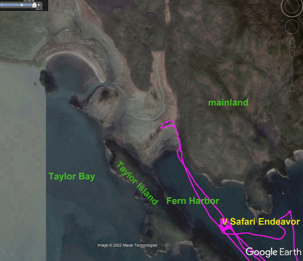
Fern Harbor. Our target for the day was Fern Harbor. This is a small inlet off of Cross Sound. Cross Sound is a 30 mile wide passage that connects Icy Strait to the Pacific Ocean. Fern Harbor is actually part of Glacier Bay National Park. However, since it is part of the so-called "outback", the crew indicated there were fewer restrictions on our activities than when we were in Glacier Bay. They were very excited to get permission to stop here. It is apparently not always possible
We arrived in Fern Harbor and dropped anchor at about 7 am. The track is shown on the map below, but the map is deceptive. The topo map for my gps (which is what is shown below) clearly shows the area to the west of the anchorage as an island. It is actually still called Taylor Island, but Brady Glacier (a glacier north and west of this area) has deposited large amounts of silt at the north end of Fern Harbor. Taylor Island is now connected to the mainland.
 |
| GPS track of our wanderings in and around Fern Harbor. Although not that old at least by geological standards (copyright 1999-2002), the map still shows Taylor Island as an island rather than connected to the mainland. |
Shown below is a more recent picture of the area. I don't know the date of the photo, but I got it here.
Taylor Island is in the center, with Fern Harbor immediately to the northeast. The front end of Brady Glacier is in the top left at the head of Taylor Bay. Brady Glacier is not a tidewater glacier but is grounded, hence all of the dirt and silt in front of it in this picture. The glacier used to extend around the northern end of Taylor Island and into the top end of Fern Harbor. That is now all filled with what looks like gray silt in this picture. That filled in gray area was the location of our afternoon "meadow walk". However, first up was a morning skiff ride
 | |
| A more current photo of Fern Harbor showing Taylor Island (in the center of the photo) connected to the mainland at the head of Fern Harbor with what looks like gray silt in this picture. Photo is from NPS: https://www.nps.gov/gis/storymaps/MapSeries/V1/index.html?appid=c91be37c36ca4db88be7a68721da52fa |
Skiff ride. As with most days, we had multiple options for off ship activities. Today we could choose from kayaking, bushwhacking, skiff ride, or meadow walk. We chose skiff ride and meadow walk. We were assigned to the morning skiff ride and the afternoon meadow walk.
It was cloudy with low-hanging fog in the distance, but it was not raining.
 |
| Looking south across Cross Sound while waiting for our skiff ride. The land to the immediate right is Taylor Island. The fog covered land in the distance probably includes the Inian Islands |
After gearing up with our life jackets, we loaded onto the pontoon boat and were off.
 |
| The Frog hanging out taking pictures in Aft 300, the staging area for off-ship adventures. |
We proceeded along the shoreline of Taylor Island and almost immediately spotted a bald eagle.
 |
| Bald eagle on Taylor Island as seen from our skiff. |
As impressive as the eagle was, I was also amazed by the sheer rock cliffs of Taylor Island. I guess it is yet more rock that has been scoured by glaciers.
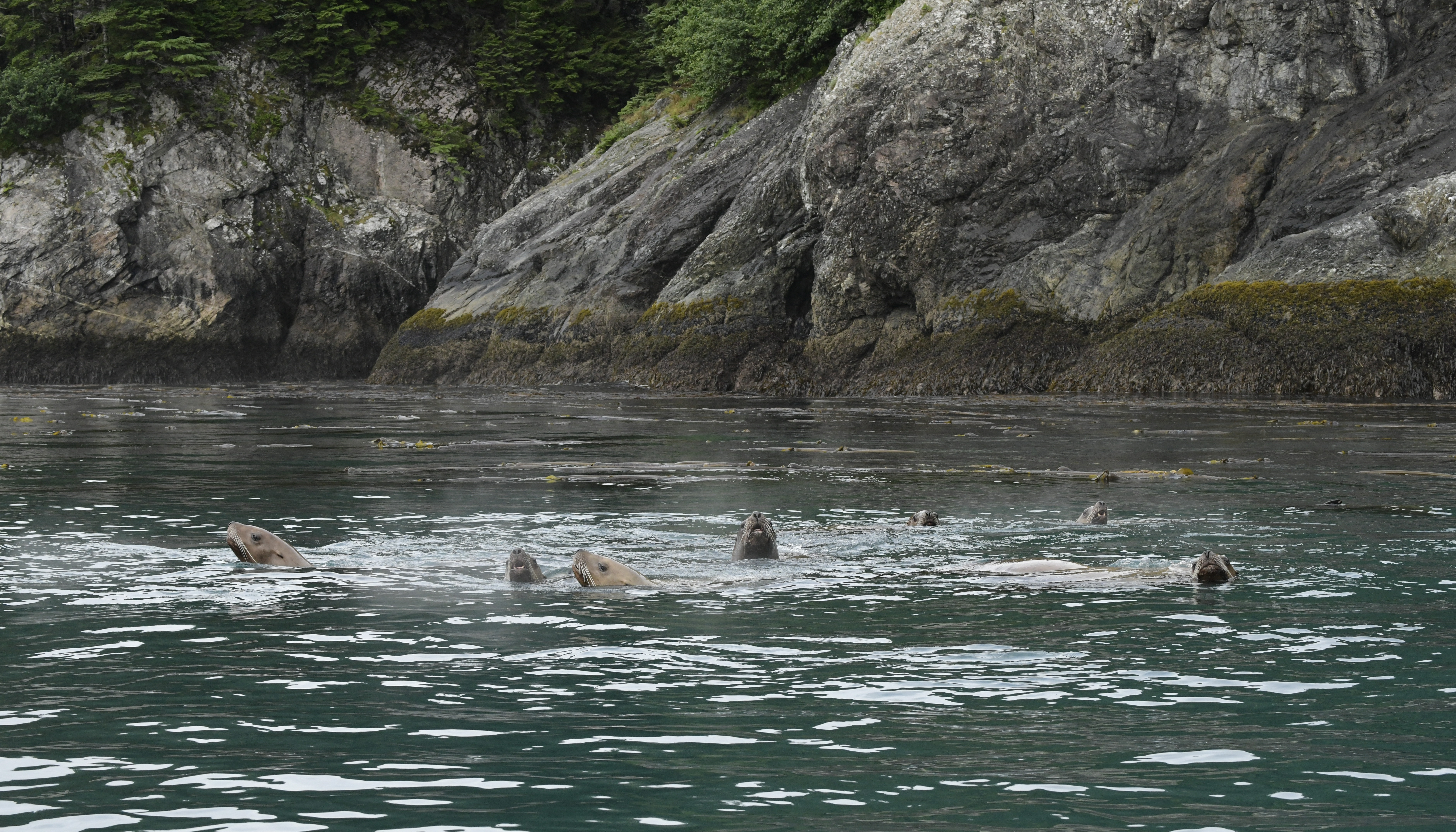 |
| Seven sea lions that followed us down the inlet. |
We quickly realized there was a group of sea lions that was following us down the inlet. I counted at least seven. They seemed very curious about us and kept raising up to check us out.
 |
| Sea lions in Fern Harbor curious about our skiff |
We looped around the end of Taylor Island, making our way under an arch at the tip of the island. This was only possible since it was low tide. The tides are huge in Alaska. It was just before 10 am when we went through the arch. The tide table (for Elfin Cove, which is close by) shows low tide was at 10:28 am at a height of -0.06 feet. The next high tide would be 4:00 pm at 9.79 feet. A swing of only 10 feet was modest. Some days in some locations the swing was over 20 feet.
 | |
| Preparing to go through the arch at the southern tip of Taylor Island. The Turkey and the Frog are in the front on the left. |
By the way, the close-up shot of our feet shows the light gray silt still on our boots from wandering around on the moraine in front of Lamplugh Glacier the day before. We had stepped into a pan of water when returning from the glacier to try to remove the silt, but we had not gotten all of it. When dry it was the consistency of flour and was all over the carpet in our cabin, much to the dismay I am sure of the crew person who had to vacuum it. Sorry!
 |
| Silt from the Lamplugh Glacier moraine walk the day before is still on our boots. |
Once on the west side of Taylor Island, we started seeing more birds. We saw many more Pigeon Guillemots like we had seen in Glacier Bay.
 |
| Pigeon Guillemots |
We also saw a group (or "gulp", yes that is the collective term for cormorants!) of cormorants on a rocky outcropping later in our wanderings.
 |
| A gulp of cormorants on a top of a rock in Fern Harbor. The light gray and brownish green stuff near the base and in the foreground to the right is seaweed which has piled up here due to low tide. |
Marbled Murrelets. Maybe the most interesting (or at least most frustrating) birds were the Marbled Murrelets. There were lots of these little guys in the water, but their super power seemed to be their ability to dive under water the moment you pointed a camera at them. It was a real struggle to get their picture.
 |
| Marbled Murrelet |
Although Marbled Murrelets are seabirds, they do not nest in colonies on cliffs or in burrows like most seabirds. They nest in the branches of old-growth conifers such as western hemlock or Sitka spruce and as far inland as 50 miles! Although this had been suspected for many years, at least according to wiki this was not confirmed until 1974. That makes it one of the last North American bird species to have its nest described.
One of our guides referred to them as "flying potatoes". Although they seemed quite adept at diving and swimming, their take-off left a bit to be desired.
 |
| A Marbled Murrelet struggling to take off |
I must admit, when in flight they do look a bit like flying potatoes.
 |
| Marbled Murrelet in flight |
The Marbled Murrelets were totally new to us, but apparently live all along the west coast of the U.S. as far south as Santa Barbara County. However, I don't know what they look like there. At least in Alaska in the winter they lose all of their brown breeding plumage and are totally black and white.
Bull kelp. As we were exploring the area, we were wandering around numerous large kelp beds. We were trying to stay out of the heaviest growth so that it did not get tangled in the propeller. One of the guides fished some of the kelp out of the water and began pulling it onto the skiff.
 |
| The guide ran the long string of kelp back and forth the length of the skiff multiple times until he finally got to the rock at the bottom. |
It was a long thin strand of vegetation which he ran back and forth at our feet the length of the skiff until he finally got to a rock which was attached to the end. Based on its appearance and the one large gas bladder (pneumatocyst), I believe this is bull kelp. It is one of two types of kelp that grow in Glacier Bay National Park.
 |
| Close-up of the picture above showing the holdfast attached to the rock (right) and the bulbous pneumatocyst (left) |
According to this source bull kelp has a root-like structure called a holdfast that attaches to rocks at its base and can grow up to 115 feet in length. They have one 4 inch gas-filled bulb which keeps the plant upright in the water. Growing from the bulb are two clusters of 30 to 64 leaf-like blades each up to 10 feet in length. Kelp are annuals, growing up to 10 inches a day. The plants grow in dense collections or forests, which are important habitat for young fish, crabs, and sea urchins. Strangely (at least to me) the bulb is filled with a significant amount of carbon monoxide -- "enough to kill a chicken" is the old wive's tales that is apparently true .
Sea otter. We had been on the look out for sea otters. Kelp beds are among their favorite places to hang out. Our guide was surprised that we had not seen any, since there are often so many in this area. Finally we spotted one lone otter in the kelp that pretty much ignored us.
 |
| A sea otter amongst the kelp |
We had seen a lot and I am sure there was more to see, but it was nearing time for lunch so back to the ship we went. Despite low clouds and fog, we had avoided any rain.
Meadow Walk. The afternoon's activity was billed as a "meadow walk", but was really another moraine walk. However it had been long time since Brady Glacier had receded from the immediate area. Vegetation was now growing on what the glacier had left behind.
Below is the gps track superimposed on a Google Earth image from October 2020, the latest non-ice covered Google Earth image I could find. It is a little hard to see, but the area between the end of Taylor Island and the mainland is filled in with lighter colored silt.
We landed on a "beach" of rocks and boulders and made our way along the tree line on the right, which is the edge between the original mainland and the fill. We then turned onto a ridge line with a few trees (now with more trees than in the picture from two years ago). The ridge is the material left by the leading edge of the glacier. Everything further northwest of the ridge was considerably lower and less rocky. Based on pictures from the folks that actually walked out on that earlier in the morning, it appears to be mostly a marshy area from silt deposit.
 |
| GPS track of meadow walk superimposed on a Google Earth image from 10/2020. Note the lighter gray color of Taylor Bay compared to Fern Harbor showing outflow of silt from Brady Glacier further up the bay. |
As we prepared to set out, the clouds and fog from this morning had cleared. It looked to be a great day for a hike.
Waiting for the skiff, we had absolutely breathtaking views of the Fairweather Mountains in the distance and the head of Brady Glacier. Brady Glacier is the largest ice stream in the Fairweather Range with a length of 32 miles. It starts in the same accumulation area of the Brady Icefield as the Lamplugh and Reid Glaciers, the glaciers we had spent so much time with the day before. I am not certain, but part of the ice between the mountain peaks in the center of the picture below may be part of the Brady Icefield.
 |
| Meadow in the foreground with Brady Glacier/Brady Icefield and the Fairweather Mountains in the distance |
The skiff dropped us off on a beach of rocks. It was very tough going until we got clear of the rocks, Even when we later made it to soil and grass, there were plenty of these types of rocks embedded in the dirt. The scenery was gorgeous, but I spent an awful lot of time watching my feet so I didn't fall.

When we got out of the rocks, we followed a social trail at the edge of the tree line. Based on markings along the side of the trail, the guide thought the trail was probably made by bears.
 |
| Following the social trail |
What scat is that? There had definitely been animals in the area. We saw both bear and moose scat, but neither were particularly fresh. How do you tell the difference? Bear scat can look very different depending upon what the bear has been eating. Bears have a simple digestive system similar to humans, with the possibility for partially undigested material left behind. Since they are omnivores, the undigested food could be almost anything from berries to bone parts.
 |
| Bear scat |
Moose on the other hand are ruminants. In other words, not only do they only eat plants as herbivores but they chew their cud. That enables them to fully digest their food, including plant cellulose. Although their droppings vary with the season, they tend to be pellets of fine textured material without food remnants.
 |
| Moose scat among the strawberry plants |
Moose are the tallest land mammals in North America. They measure six feet from the ground to their shoulders and weigh up to 1500 pounds. The Frog really wanted to see a moose on this trip. However, given their enormous size, I am glad we did not come face to face with Bullwinkle on the trail.
Berries. Alaska is known for its many types of berries. We saw several on our hike. We tasted some of the salmon berries, which look a little like raspberries. We also saw strawberries and maybe some others.
 |
| Salmon berries |
 |
| On the moraine ridge. Note the trees, even though many are small. It takes Sitka spruce approximately 40 years after a glacier covered area is exposed before trees appear. |
 |
| Looking out over the marsh from the moraine ridge |
 |
| Marsh in the foreground with the stream which had been visible in the Google Earth photo above. The Fairweather Mountains are in the distance. |
 |
| The Safari Endeavor from the moraine ridge |
We saw a variety of interesting plants. The presence of Sitka spruce on the ridge suggested this area has been exposed for some time, maybe as much as fifty years. As explained in this earth cache, Sitka spruce require approximately 40 years after a glacier retreats before they appear. They can then grow as much as five feet a year.
Although there were some trees, most of the plants were smaller. There had just not been enough time since the glacier left for most larger plants to become established.
 |
| Seaside Pea |
 |
| Rice root |
Cow parsnip poisoning. Among the plants, I apparently encountered some cow parsnip. My wrist and arm became red and blistered in a couple of spots the day after our hike. It was very minor, but still just one more thing to learn about. Most notably, the crew told me the chemicals reacting with the skin are UV activated. This was the first sunny day we had been out, so it is possible I contacted it in Mendenhall and it only appeared now In any case I kept the areas covered for the remainder of the trip. The crew also gave me some hydrocortisone, which helped with the itching..
Fortunately the tide had come up enough by the time the skiff retrieved us that we had only a short trek over the rock field.
It had turned into such a glorious day, we just had to enjoy the view.
 |
| Kayakers returning to the ship with Cross Sound in the background |
We weighed anchor about 8:45. As we left Fern Harbor and got into Cross Sound the ship started to bounce around quite a bit. This was the first time on this cruise we had had any rough seas. Cross Sound is exposed to the Pacific Ocean and apparently there was weather blowing in from the west. This continued until we got quite a bit further eastward in Icy Inlet. The Frog is particularly sensitive to motion sickness, but he made it through ok by lying on the bed with his eyes closed.
It had been another full day. Here are the day's iNaturalist posts.
No comments:
Post a Comment