Monday, April 8
Carlsbad Caverns
After a quick breakfast in our hotel in Carlsbad, we made the 20+ mile trip down US 62 to Whites City and on to Carlsbad National Park. We had stayed in Carlsbad the night before because the web indicated a limited selection of places to stay and eat in Whites City. Now having seen Whites City, I think we definitely made the right choice.
There is a seven mile drive into the visitor's center, which sits on top of the ridge. There are two ways to enter the caverns: (1) the Natural Entrance route, a 1.25 mile walk down the natural entrance with a 750 foot drop in elevation, or (2) the elevators. To save our knees and to allow more time for the main tour below, we chose the elevators. We had been a bit concerned about this prior to our arrival, since the elevators are undergoing a massive renovation. There were online reports of massive wait times for the elevators. However, this was one of the first major advantages of retirement...there was no waiting early on a Monday morning in April! In fact, there were relatively few people in the cave period. Definitely a major plus.
Once to the bottom, we began our trek around the "Big Room". The self-guided tour is a one way counter clockwise trek of about one mile. See the route marked in red on the two maps below. The blue route is the end of the Natural Entrance route.
 |
| Top portion of the map |
 |
| Bottom portion of the map |
The Frog took many pictures, essentially all with a tripod and all with multiple exposures...it was, after all, very dark down there despite the numerous lights of many kinds.
He certainly plans to play with those pictures and try a number of different things. I will pick out just a few and try to identify the correct name on the map where I can.
 |
| Mirror Lake |
 |
| Looking towards Rock of Ages (on right) from before Crystal Spring Dome. Note the people just to the left of center |
 |
| Rock of Ages |
Frog had a camera mishap at the Rock of Ages...the camera did not lock properly onto the tripod and fell. The bad news was that the lens was severely damaged. The good news was (1) that it happened here, where there was plenty of room and nothing was lost permanently into some bottomless pit; (2) that the camera was ok; and (3) the lens was later repaired successfully by Nikon.
The caverns were huge, but it was hard to get a sense of the immense size. The unusually large size of the caverns is due to the fact that the limestone (calcium carbonate) was dissolved by sulfuric acid rather than the typical carbonic acid in other caverns. The sulfuric acid was formed from the reaction of hydrogen sulfide (migrating up from the petroleum reservoirs below) and oxygen. Evidence for this comes from the large amounts of gypsum found in the caverns. Gypsum (calcium sulfate) is formed from the reaction of sulfuric acid and limestone.
In any case, it was truly spectacular and well worth the trip. I would definitely go back again, especially if we could be there when there were so few people in the caverns.
Guadalupe Mountains NP
Following lunch at the Visitor's Center at Carlsbad Caverns and a trip on the unpaved road around the surface part of the park, we headed for Guadalupe Mountains National Park. The winds were terrible from the west and I was fighting with the steering. There was at least one time when I was continuing to steer to the right to go around a slight curve to the left. In any case we made it to Guadalupe Mountains NP.
Since we did not plan to take one of the longer hikes, there was not a lot to do at this park. We did take the short nature trail to what is left of a Butterfield Stage Station. We also enjoyed some of the plants that were beginning to flower.
However, the real highlight of this stop was the view of El Capitan from the picnic area just south of the park off of US 62.
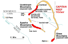
El Capitan and Carlsbad Caverns are both part of the Capitan Reef, formed during the Permian Period. However, I did not know until this trip that the mountains north of Van Horn are also exposed reef.
 |
| The Capitan Reef developed along the margin of the Delaware Sea during the Permian Period. The Guadalupe Mountains, Apache Mountains, and Glass Mountains are exposed portions of that ancient reef, now recognized as one of the most well-preserved fossil reefs in the world. |
After the quick stop to enjoy the view of El Capitan, we continued on and were to Van Horn in another hour. Tuesday was an uneventful trip home.


No comments:
Post a Comment